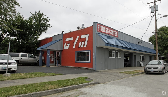
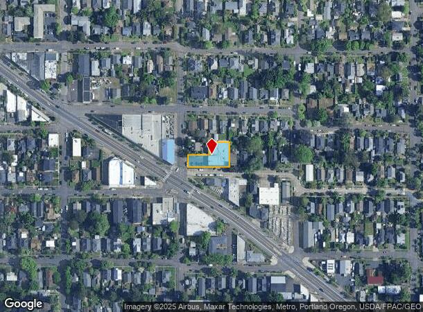
Property Record
5621 Se Center St, Portland, OR 97206

NEARBY LISTINGS FOR SALE OR LEASE
Property Detail
5621 Se Center St
Portland-Vancouver-Hillsboro, OR-WA
Watts Sub
R298594
WATTS SUB, BLOCK 2, S 1/2 OF LOT 11&12, LOT 13&14
Commercialnec
Multnomah
ARE
Oregon
41051C0400H
11-12
2025
0.28 AC
2025
Mall 205
000802
Portland
7,680 SF
DEMOGRAPHICS near 5621 Se Center St
1 Mile
3 Mile
5 Mile
2024 Total Population
26,708
196,907
494,903
2029 Population
25,980
192,653
488,540
Pop Growth 2024-2029
(2.73%)
(2.16%)
(1.29%)
Average Age
40
40
40
2024 Total Households
11,457
83,799
217,309
HH Growth 2024-2029
(3.03%)
(2.45%)
(1.33%)
Median Household Inc
$84,719
$82,777
$78,593
Avg Household Size
2.30
2.20
2.20
2024 Avg HH Vehicles
2.00
2.00
1.00
Median Home Value
$496,239
$526,233
$517,458
Median Year Built
1952
1953
1965
Nearby Places
Map Layers
Map Styles
 Street
 Aerial
- Restaurants
- Banks
- Shops
- Fitness
- Groceries
PUBLIC TRANSPORTATION
COMMUTER RAIL
Portland (Amtrak Cascades - Amtrak, Coast Starlight - Amtrak, Empire Builder - Amtrak)
DRIVE
WALK
Distance
Portland (Amtrak Cascades - Amtrak, Coast Starlight - Amtrak, Empire Builder - Amtrak)
16 min
5.4 mi
AIRPORT
Portland International
DRIVE
WALK
Distance
Portland International
20 min
10.4 mi
Freight Ports
Port of Portland
DRIVE
WALK
Distance
Port of Portland
17 min
7.7 mi
Nearby Properties
Address
Land Use
TOTAL SIZE
Lot Size
Zoning
Address
Land Use
TOTAL SIZE
Lot Size
Zoning
822,867 SF
103.39 AC
CI1
Address
Land Use
TOTAL SIZE
Lot Size
Zoning
1.09 AC
EX
Address
Land Use
TOTAL SIZE
Lot Size
Zoning
1,024 SF
15.92 AC
OS
Address
Land Use
TOTAL SIZE
Lot Size
Zoning
183,664 SF
8.96 AC
R5
Address
Land Use
TOTAL SIZE
Lot Size
Zoning
280,069 SF
18.31 AC
IR
Address
Land Use
TOTAL SIZE
Lot Size
Zoning
Address
Land Use
TOTAL SIZE
Lot Size
Zoning
147,334 SF
10.92 AC
IG1
Address
Land Use
TOTAL SIZE
Lot Size
Zoning
250,280 SF
23.86 AC
IR
Address
Land Use
TOTAL SIZE
Lot Size
Zoning
31,878 SF
15.95 AC
IG2
Address
Land Use
TOTAL SIZE
Lot Size
Zoning
54,676 SF
190.32 AC
OS
Address
Land Use
TOTAL SIZE
Lot Size
Zoning
198,107 SF
4.03 AC
R2.5
Address
Land Use
TOTAL SIZE
Lot Size
Zoning
42,839,055 SF
19.25 AC
CI1
Address
Land Use
TOTAL SIZE
Lot Size
Zoning
44,644 SF
2.18 AC
R2
Address
Land Use
TOTAL SIZE
Lot Size
Zoning
64,673 SF
NULL
Address
Land Use
TOTAL SIZE
Lot Size
Zoning
100,217 SF
1.99 AC
R5
Address
Land Use
TOTAL SIZE
Lot Size
Zoning
362,725 SF
16.52 AC
IG1
Address
Land Use
TOTAL SIZE
Lot Size
Zoning
15.05 AC
CC
Address
Land Use
TOTAL SIZE
Lot Size
Zoning
205,034 SF
0.38 AC
RM1
Address
Land Use
TOTAL SIZE
Lot Size
Zoning
2,108 SF
12.08 AC
HDR
Address
Land Use
TOTAL SIZE
Lot Size
Zoning
113,582 SF
5.29 AC
R5
Address
Land Use
TOTAL SIZE
Lot Size
Zoning
361,241 SF
1.80 AC
CI2
Address
Land Use
TOTAL SIZE
Lot Size
Zoning
222,120 SF
6.87 AC
RM2
Address
Land Use
TOTAL SIZE
Lot Size
Zoning
101,812 SF
3.14 AC
R5
Address
Land Use
TOTAL SIZE
Lot Size
Zoning
57,300 SF
4.38 AC
R5
Address
Land Use
TOTAL SIZE
Lot Size
Zoning
230,105 SF
3.08 AC
CI2
Address
Land Use
TOTAL SIZE
Lot Size
Zoning
369,835 SF
6.67 AC
IRD
Address
Land Use
TOTAL SIZE
Lot Size
Zoning
137,908 SF
1.83 AC
R2.5
Address
Land Use
TOTAL SIZE
Lot Size
Zoning
21,200 SF
16.03 AC
OS
Address
Land Use
TOTAL SIZE
Lot Size
Zoning
64,658 SF
7.79 AC
R5
Address
Land Use
TOTAL SIZE
Lot Size
Zoning
176,428 SF
1.31 AC
CM2
The World's #1 Commercial Real Estate Marketplace
Connect with us
© 2026 CoStar Group
The information above has been obtained from sources believed reliable. While we do not doubt its accuracy we have not verified it and make no guarantee, warranty or representation about it. It is your responsibility to independently confirm its accuracy and completeness. Any projections, opinions, assumptions, or estimates used are for example only and do not represent the current or future performance of the property. The value of this transaction to you depends on tax and other factors which should be evaluated by your tax, financial, and legal advisors. You and your advisors should conduct a careful, independent investigation of the property to determine to your satisfaction the suitability of the property for your needs.