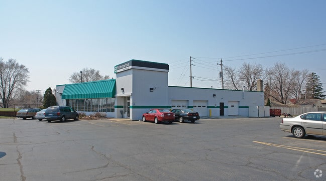
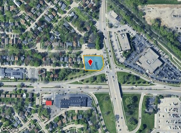
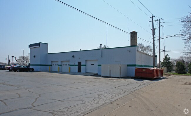
Property Record
5623 N Green Bay Ave, Milwaukee, WI 53209

NEARBY LISTINGS FOR SALE OR LEASE
Property Detail
5623 N Green Bay Ave
Milwaukee-Waukesha-West Allis, WI
Crestwood Subd
169-0498-001
CRESTWOOD SUBDIVISION, SE 1/4 SEC. 25-8-21 & S 1/2 SEC. 30-8-22, LOTS 10, 11 & 12, BLK. 20. ALSO PART OF ACCESS AVE. COMM AT NE COR SD LOT 10; TH E 56.80 FT, SLY 53.10 FT, 25.00 FT; SWLY 25.00 FT, 25.00 FT, 17.77 FT, 24.82 FT; NWLY 54.80 FT; TH N 88.
Commercialnec
Milwaukee
X
Wisconsin
55079C0081E
10-12
2024
0.55 AC
2024
Milwaukee NW
060200
Milwaukee/Madison
5,800 SF
DEMOGRAPHICS near 5623 N Green Bay Ave
1 Mile
3 Mile
5 Mile
2024 Total Population
10,426
118,264
332,321
2029 Population
10,206
116,533
326,946
Pop Growth 2024-2029
(2.11%)
(1.46%)
(1.62%)
Average Age
40
37
36
2024 Total Households
4,582
46,565
133,850
HH Growth 2024-2029
(2.18%)
(1.60%)
(1.78%)
Median Household Inc
$44,317
$45,762
$47,862
Avg Household Size
2.20
2.50
2.40
2024 Avg HH Vehicles
1.00
1.00
1.00
Median Home Value
$174,480
$172,786
$176,924
Median Year Built
1953
1950
1951
Nearby Places
Map Layers
Map Styles
 Street
 Aerial
- Restaurants
- Banks
- Shops
- Fitness
- Groceries
PUBLIC TRANSPORTATION
COMMUTER RAIL
DRIVE
WALK
Distance
14 min
6.6 mi
AIRPORT
General Mitchell International
DRIVE
WALK
Distance
General Mitchell International
24 min
13.2 mi
Freight Ports
Port Milwaukee
DRIVE
WALK
Distance
Port Milwaukee
17 min
9.0 mi
SALE & LEASE HISTORY
LISTING DATE
SALE/LEASE

Sep 25, 2016
For Lease
Sep 24, 2016
For Sale
Mar 20, 2017
For Sale
Mar 17, 2017
For Lease
Nearby Properties
Address
Land Use
TOTAL SIZE
Lot Size
Zoning
Address
Land Use
TOTAL SIZE
Lot Size
Zoning
305,573 SF
3.20 AC
Address
Land Use
TOTAL SIZE
Lot Size
Zoning
66,245 SF
10.21 AC
Address
Land Use
TOTAL SIZE
Lot Size
Zoning
527,776 SF
33.23 AC
Address
Land Use
TOTAL SIZE
Lot Size
Zoning
685,390 SF
26.20 AC
Address
Land Use
TOTAL SIZE
Lot Size
Zoning
152,640 SF
10.50 AC
Address
Land Use
TOTAL SIZE
Lot Size
Zoning
171,170 SF
25.88 AC
Address
Land Use
TOTAL SIZE
Lot Size
Zoning
224,756 SF
12 AC
RESIDENTIA
Address
Land Use
TOTAL SIZE
Lot Size
Zoning
145,218 SF
10.23 AC
Address
Land Use
TOTAL SIZE
Lot Size
Zoning
145,605 SF
2.64 AC
Address
Land Use
TOTAL SIZE
Lot Size
Zoning
241,520 SF
6.60 AC
Address
Land Use
TOTAL SIZE
Lot Size
Zoning
Address
Land Use
TOTAL SIZE
Lot Size
Zoning
294,553 SF
6.19 AC
Address
Land Use
TOTAL SIZE
Lot Size
Zoning
113,542 SF
2.31 AC
Address
Land Use
TOTAL SIZE
Lot Size
Zoning
213,218 SF
11 AC
Address
Land Use
TOTAL SIZE
Lot Size
Zoning
235,364 SF
7.20 AC
Address
Land Use
TOTAL SIZE
Lot Size
Zoning
90,714 SF
4.18 AC
Address
Land Use
TOTAL SIZE
Lot Size
Zoning
195,507 SF
1.92 AC
Address
Land Use
TOTAL SIZE
Lot Size
Zoning
298,666 SF
5.09 AC
PD
Address
Land Use
TOTAL SIZE
Lot Size
Zoning
2.15 AC
RT4
Address
Land Use
TOTAL SIZE
Lot Size
Zoning
72,676 SF
6.22 AC
Address
Land Use
TOTAL SIZE
Lot Size
Zoning
66.42 AC
IL1
Address
Land Use
TOTAL SIZE
Lot Size
Zoning
74,526 SF
5.42 AC
Address
Land Use
TOTAL SIZE
Lot Size
Zoning
194,400 SF
8.09 AC
Address
Land Use
TOTAL SIZE
Lot Size
Zoning
137,100 SF
6.69 AC
IL2
Address
Land Use
TOTAL SIZE
Lot Size
Zoning
48,540 SF
4.28 AC
Address
Land Use
TOTAL SIZE
Lot Size
Zoning
127,584 SF
3.28 AC
Address
Land Use
TOTAL SIZE
Lot Size
Zoning
18.54 AC
RS6
Address
Land Use
TOTAL SIZE
Lot Size
Zoning
61,910 SF
7.84 AC
Address
Land Use
TOTAL SIZE
Lot Size
Zoning
36,755 SF
6.44 AC
Address
Land Use
TOTAL SIZE
Lot Size
Zoning
118,400 SF
13.25 AC
IL2
The World's #1 Commercial Real Estate Marketplace
Connect with us
© 2025 CoStar Group
The information above has been obtained from sources believed reliable. While we do not doubt its accuracy we have not verified it and make no guarantee, warranty or representation about it. It is your responsibility to independently confirm its accuracy and completeness. Any projections, opinions, assumptions, or estimates used are for example only and do not represent the current or future performance of the property. The value of this transaction to you depends on tax and other factors which should be evaluated by your tax, financial, and legal advisors. You and your advisors should conduct a careful, independent investigation of the property to determine to your satisfaction the suitability of the property for your needs.