Property Record
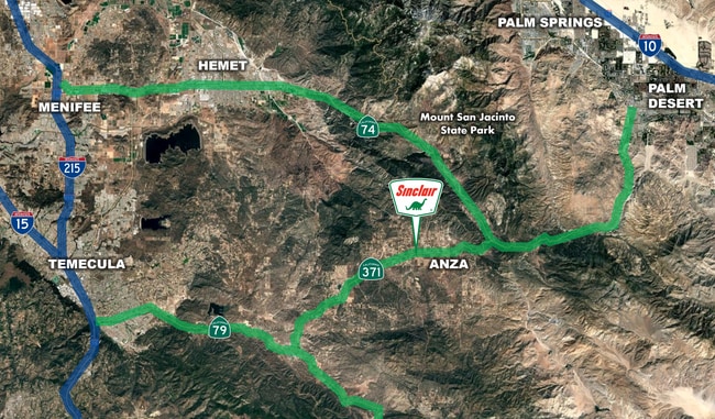
56245 Highway 371 Rd, Anza, CA 92539
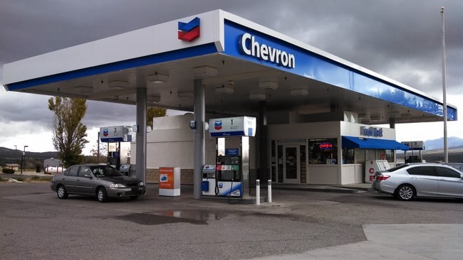


This Property Is For Sale
NEARBY LISTINGS FOR SALE OR LEASE
-
-
View all Anza listings for sale on LoopNet.com
Property Detail
56245 Highway 371 Rd
Riverside-San Bernardino-Ontario, CA
Parcel Map No 26396
576-080-013
.83 ACRES NET IN PAR 6 PM 184/058 PM 26396
Servicestation
Riverside
X
California
06065C2825G
6
2024
0.83 AC
2025
Riverside Outlying
044403
Inland Empire (California)
1,560 SF
DEMOGRAPHICS near 56245 Highway 371 Rd
1 Mile
3 Mile
5 Mile
2024 Total Population
125
1,418
3,236
2029 Population
123
1,398
3,206
Pop Growth 2024-2029
(1.60%)
(1.41%)
(0.93%)
Average Age
43
44
44
2024 Total Households
48
546
1,241
HH Growth 2024-2029
(2.08%)
(2.38%)
(1.85%)
Median Household Inc
$47,500
$47,952
$48,697
Avg Household Size
2.50
2.40
2.40
2024 Avg HH Vehicles
2.00
2.00
2.00
Median Home Value
$250,000
$270,526
$295,057
Median Year Built
1985
1984
1984
Nearby Places
- Restaurants
- Banks
- Shops
- Fitness
- Groceries
PUBLIC TRANSPORTATION
AIRPORT
Palm Springs International
DRIVE
WALK
Distance
Palm Springs International
62 min
41.8 mi
Freight Ports
Port of San Diego
DRIVE
WALK
Distance
Port of San Diego
119 min
91.8 mi
Nearby Properties
Address
Land Use
TOTAL SIZE
Lot Size
Zoning
Address
Land Use
TOTAL SIZE
Lot Size
Zoning
12,935 SF
3.53 AC
A1212
Address
Land Use
TOTAL SIZE
Lot Size
Zoning
9,100 SF
1.31 AC
Address
Land Use
TOTAL SIZE
Lot Size
Zoning
5,040 SF
2.33 AC
RR
Address
Land Use
TOTAL SIZE
Lot Size
Zoning
5,040 SF
1.36 AC
RR
Address
Land Use
TOTAL SIZE
Lot Size
Zoning
5,000 SF
4.32 AC
MM
Address
Land Use
TOTAL SIZE
Lot Size
Zoning
8,692 SF
0.80 AC
CPS
Address
Land Use
TOTAL SIZE
Lot Size
Zoning
4,500 SF
0.91 AC
MM
Address
Land Use
TOTAL SIZE
Lot Size
Zoning
1,032 SF
20 AC
AL
Address
Land Use
TOTAL SIZE
Lot Size
Zoning
3,840 SF
1.74 AC
C1CP
Address
Land Use
TOTAL SIZE
Lot Size
Zoning
3,200 SF
7.76 AC
MIX
Address
Land Use
TOTAL SIZE
Lot Size
Zoning
1,716 SF
0.84 AC
CPS
Address
Land Use
TOTAL SIZE
Lot Size
Zoning
1,680 SF
0.35 AC
CPS
Address
Land Use
TOTAL SIZE
Lot Size
Zoning
52.03 AC
RR
Address
Land Use
TOTAL SIZE
Lot Size
Zoning
2,489 SF
43.43 AC
RR
Address
Land Use
TOTAL SIZE
Lot Size
Zoning
8,499 SF
9.25 AC
CPS
Address
Land Use
TOTAL SIZE
Lot Size
Zoning
2,480 SF
20 AC
RR212
Address
Land Use
TOTAL SIZE
Lot Size
Zoning
5,792 SF
2.50 AC
RR212
Address
Land Use
TOTAL SIZE
Lot Size
Zoning
5,098 SF
2.27 AC
RR212
Address
Land Use
TOTAL SIZE
Lot Size
Zoning
1,866 SF
0.37 AC
CPS
Address
Land Use
TOTAL SIZE
Lot Size
Zoning
9.56 AC
MSC
Address
Land Use
TOTAL SIZE
Lot Size
Zoning
960 SF
120 AC
RR20
Address
Land Use
TOTAL SIZE
Lot Size
Zoning
3,876 SF
40.66 AC
RR20
Address
Land Use
TOTAL SIZE
Lot Size
Zoning
3,152 SF
5 AC
RR
Address
Land Use
TOTAL SIZE
Lot Size
Zoning
3,960 SF
1.07 AC
CPS
Address
Land Use
TOTAL SIZE
Lot Size
Zoning
3,471 SF
160 AC
A110
Address
Land Use
TOTAL SIZE
Lot Size
Zoning
39.79 AC
RR5
Address
Land Use
TOTAL SIZE
Lot Size
Zoning
133.93 AC
RR20
The World's #1 Commercial Real Estate Marketplace
Connect with us
© 2025 CoStar Group
The information above has been obtained from sources believed reliable. While we do not doubt its accuracy we have not verified it and make no guarantee, warranty or representation about it. It is your responsibility to independently confirm its accuracy and completeness. Any projections, opinions, assumptions, or estimates used are for example only and do not represent the current or future performance of the property. The value of this transaction to you depends on tax and other factors which should be evaluated by your tax, financial, and legal advisors. You and your advisors should conduct a careful, independent investigation of the property to determine to your satisfaction the suitability of the property for your needs.