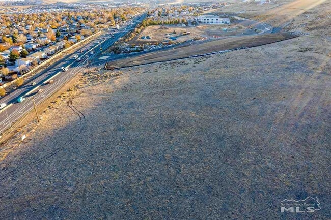
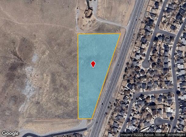
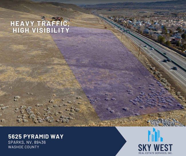
Property Record
5625 Pyramid Way, Sparks, NV 89436

This Property Is For Sale
NEARBY LISTINGS FOR SALE OR LEASE
Property Detail
5625 Pyramid Way
Reno, NV
_Unspecified
083-730-07
PM 308 LT 4
Vacantlandnec
Washoe
X
Nevada
32031C3051G
4
2025
5.41 AC
2026
Sparks
003503
Reno/Sparks
DEMOGRAPHICS near 5625 Pyramid Way
1 Mile
3 Mile
5 Mile
2024 Total Population
6,308
63,229
175,985
2029 Population
6,588
66,647
185,596
Pop Growth 2024-2029
+ 4.44%
+ 5.41%
+ 5.46%
Average Age
39
39
39
2024 Total Households
2,386
22,026
65,125
HH Growth 2024-2029
+ 4.57%
+ 5.53%
+ 5.72%
Median Household Inc
$87,447
$86,260
$73,622
Avg Household Size
2.60
2.80
2.60
2024 Avg HH Vehicles
2.00
2.00
2.00
Median Home Value
$405,190
$399,943
$406,851
Median Year Built
2002
1996
1992
Nearby Places
Map Layers
Map Styles
 Street
 Aerial
- Restaurants
- Banks
- Shops
- Fitness
- Groceries
PUBLIC TRANSPORTATION
COMMUTER RAIL
Reno (California Zephyr - Amtrak)
DRIVE
WALK
Distance
Reno (California Zephyr - Amtrak)
17 min
8.6 mi
AIRPORT
Reno/Tahoe International
DRIVE
WALK
Distance
Reno/Tahoe International
35 min
12.3 mi
Freight Ports
Port of Stockton
DRIVE
WALK
Distance
Port of Stockton
220 min
186.7 mi
Nearby Properties
Address
Land Use
TOTAL SIZE
Lot Size
Zoning
Address
Land Use
TOTAL SIZE
Lot Size
Zoning
294,872 SF
69.02 AC
PF
Address
Land Use
TOTAL SIZE
Lot Size
Zoning
406,338 SF
15.07 AC
NUD
Address
Land Use
TOTAL SIZE
Lot Size
Zoning
416,482 SF
21.84 AC
PD
Address
Land Use
TOTAL SIZE
Lot Size
Zoning
333,867 SF
14.71 AC
NUD
Address
Land Use
TOTAL SIZE
Lot Size
Zoning
271,111 SF
31.84 AC
NUD
Address
Land Use
TOTAL SIZE
Lot Size
Zoning
308,431 SF
20 AC
PD
Address
Land Use
TOTAL SIZE
Lot Size
Zoning
321,941 SF
36 AC
NUD
Address
Land Use
TOTAL SIZE
Lot Size
Zoning
236,695 SF
8.66 AC
PD
Address
Land Use
TOTAL SIZE
Lot Size
Zoning
279,596 SF
10.94 AC
NUD
Address
Land Use
TOTAL SIZE
Lot Size
Zoning
231,353 SF
11.52 AC
NUD
Address
Land Use
TOTAL SIZE
Lot Size
Zoning
188,281 SF
641.92 AC
OS 88% / G
Address
Land Use
TOTAL SIZE
Lot Size
Zoning
181,857 SF
8.19 AC
NUD
Address
Land Use
TOTAL SIZE
Lot Size
Zoning
203,303 SF
20.97 AC
C2
Address
Land Use
TOTAL SIZE
Lot Size
Zoning
146,255 SF
9.99 AC
MDU
Address
Land Use
TOTAL SIZE
Lot Size
Zoning
197,364 SF
11.34 AC
NUD
Address
Land Use
TOTAL SIZE
Lot Size
Zoning
186,572 SF
12.17 AC
NUD
Address
Land Use
TOTAL SIZE
Lot Size
Zoning
74,637 SF
6.04 AC
NUD
Address
Land Use
TOTAL SIZE
Lot Size
Zoning
148,346 SF
15.79 AC
NUD
Address
Land Use
TOTAL SIZE
Lot Size
Zoning
70,030 SF
36.71 AC
PSP
Address
Land Use
TOTAL SIZE
Lot Size
Zoning
269,970 SF
54 AC
PF
Address
Land Use
TOTAL SIZE
Lot Size
Zoning
115,817 SF
11.27 AC
NUD
Address
Land Use
TOTAL SIZE
Lot Size
Zoning
38,107 SF
9.10 AC
PF
Address
Land Use
TOTAL SIZE
Lot Size
Zoning
137,236 SF
10.02 AC
PD
Address
Land Use
TOTAL SIZE
Lot Size
Zoning
57,702 SF
5.27 AC
PD
Address
Land Use
TOTAL SIZE
Lot Size
Zoning
81,122 SF
8.44 AC
NUD
Address
Land Use
TOTAL SIZE
Lot Size
Zoning
35.59 AC
NUD
Address
Land Use
TOTAL SIZE
Lot Size
Zoning
89,264 SF
13.16 AC
C2
Address
Land Use
TOTAL SIZE
Lot Size
Zoning
40.56 AC
NUD
Address
Land Use
TOTAL SIZE
Lot Size
Zoning
102,489 SF
10.99 AC
NUD
Address
Land Use
TOTAL SIZE
Lot Size
Zoning
87,888 SF
9.58 AC
C2
The World's #1 Commercial Real Estate Marketplace
Connect with us
© 2025 CoStar Group
The information above has been obtained from sources believed reliable. While we do not doubt its accuracy we have not verified it and make no guarantee, warranty or representation about it. It is your responsibility to independently confirm its accuracy and completeness. Any projections, opinions, assumptions, or estimates used are for example only and do not represent the current or future performance of the property. The value of this transaction to you depends on tax and other factors which should be evaluated by your tax, financial, and legal advisors. You and your advisors should conduct a careful, independent investigation of the property to determine to your satisfaction the suitability of the property for your needs.