Property Record
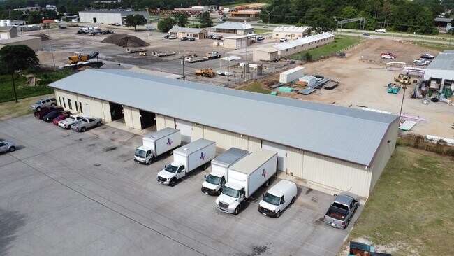
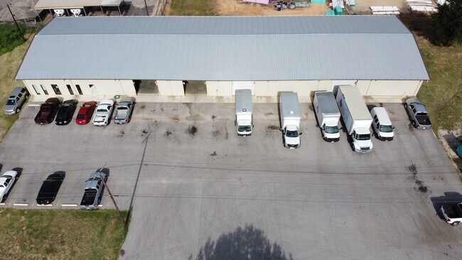
5625 Shirley Dr, Tyler, TX 75708

Property Detail
5625 Shirley Dr
Tyler, TX
NEGEM IND PARK BLOCK 1 LOT 2
1-80872-0001-00-002000
Smith
Warehouse
Texas
B and X Area of moderate flood hazard, usually the area between the limits of the 100-year and 500-year floods.
2
2025
1.37 AC
2025
Tyler
001701
Other Market Areas
960 SF
NEARBY LISTINGS FOR SALE OR LEASE
DEMOGRAPHICS near 5625 Shirley Dr
1 mile
3 mile
5 mile
2024 Total Population
1,745
21,556
67,130
2029 Population
1,913
23,574
73,260
Pop Growth 2024-2029
+ 9.63%
+ 9.36%
+ 9.13%
Average Age
33
34
35
2024 Total Households
559
7,049
23,330
HH Growth 2024-2029
+ 9.12%
+ 8.89%
+ 8.70%
Median Household Inc
$52,957
$47,681
$49,345
Avg Household Size
3.00
2.90
2.60
2024 Avg HH Vehicles
2.00
2.00
2.00
Median Home Value
$130,434
$113,594
$127,546
Median Year Built
1974
1972
1966
Nearby Places
Map Layers
Map Styles
 Street
 Aerial
Transit
 Traffic
 Biking
Places
Listings with unknown addresses are not visible on the map
- Restaurants
- Banks
- Shops
- Fitness
- Groceries
PUBLIC TRANSPORTATION
AIRPORT
Tyler Pounds Regional
Drive
Walk
Distance
Tyler Pounds Regional
22 min
11.7 mi
SALE & LEASE HISTORY
LISTING DATE
SALE/LEASE

Jul 20, 2020
For Sale
Nearby Properties
Address
Land Use
TOTAL SIZE
Lot Size
Zoning
Address
Land Use
TOTAL SIZE
Lot Size
Zoning
14,000 SF
144.13 AC
M2
Address
Land Use
TOTAL SIZE
Lot Size
Zoning
Address
Land Use
TOTAL SIZE
Lot Size
Zoning
Address
Land Use
TOTAL SIZE
Lot Size
Zoning
Address
Land Use
TOTAL SIZE
Lot Size
Zoning
12,810 SF
12.07 AC
R1A
Address
Land Use
TOTAL SIZE
Lot Size
Zoning
111,750 SF
26 AC
Address
Land Use
TOTAL SIZE
Lot Size
Zoning
Address
Land Use
TOTAL SIZE
Lot Size
Zoning
25.54 AC
INT
Address
Land Use
TOTAL SIZE
Lot Size
Zoning
184,670 SF
18.22 AC
Address
Land Use
TOTAL SIZE
Lot Size
Zoning
Address
Land Use
TOTAL SIZE
Lot Size
Zoning
1,714 SF
13.36 AC
RMF
Address
Land Use
TOTAL SIZE
Lot Size
Zoning
520,081 SF
24.62 AC
M2
Address
Land Use
TOTAL SIZE
Lot Size
Zoning
3,222 SF
7.43 AC
RMF
Address
Land Use
TOTAL SIZE
Lot Size
Zoning
16,800 SF
12.99 AC
RMF
Address
Land Use
TOTAL SIZE
Lot Size
Zoning
91.33 AC
M2
Address
Land Use
TOTAL SIZE
Lot Size
Zoning
41,052 SF
5.32 AC
Address
Land Use
TOTAL SIZE
Lot Size
Zoning
1,375 SF
8.50 AC
RMF
Address
Land Use
TOTAL SIZE
Lot Size
Zoning
4.20 AC
PMF
Address
Land Use
TOTAL SIZE
Lot Size
Zoning
2,514 SF
10.58 AC
Address
Land Use
TOTAL SIZE
Lot Size
Zoning
Address
Land Use
TOTAL SIZE
Lot Size
Zoning
72,000 SF
24.16 AC
Address
Land Use
TOTAL SIZE
Lot Size
Zoning
2,454 SF
12.93 AC
M2
Address
Land Use
TOTAL SIZE
Lot Size
Zoning
3,319 SF
18 AC
Address
Land Use
TOTAL SIZE
Lot Size
Zoning
Address
Land Use
TOTAL SIZE
Lot Size
Zoning
28,771 SF
4.47 AC
Address
Land Use
TOTAL SIZE
Lot Size
Zoning
14,588 SF
22.07 AC
Address
Land Use
TOTAL SIZE
Lot Size
Zoning
27,006 SF
12.54 AC
Address
Land Use
TOTAL SIZE
Lot Size
Zoning
25.81 AC
R1B
Address
Land Use
TOTAL SIZE
Lot Size
Zoning
Address
Land Use
TOTAL SIZE
Lot Size
Zoning
59,269 SF
8.73 AC
The World's #1 Commercial Real Estate Marketplace
Connect with us
© 2026 CoStar Group
The information above has been obtained from sources believed reliable. While we do not doubt its accuracy we have not verified it and make no guarantee, warranty or representation about it. It is your responsibility to independently confirm its accuracy and completeness. Any projections, opinions, assumptions, or estimates used are for example only and do not represent the current or future performance of the property. The value of this transaction to you depends on tax and other factors which should be evaluated by your tax, financial, and legal advisors. You and your advisors should conduct a careful, independent investigation of the property to determine to your satisfaction the suitability of the property for your needs.