Property Record
563 Patterson Blvd, Fairfield, OH 45014
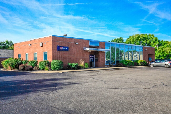


Property Detail
563 Patterson Blvd
A0700-008-000-147
198 SE COR SEE TIF PCL 147T - N TOWN CENTER TIF
Financialbuilding
Butler
B and X Area of moderate flood hazard, usually the area between the limits of the 100-year and 500-year floods.
Ohio
2024
0.85 AC
2025
Butler County
010901
Cincinnati/Dayton
4,080 SF
Cincinnati, OH-KY-IN
NEARBY LISTINGS FOR SALE OR LEASE
DEMOGRAPHICS near 563 Patterson Blvd
1 mile
3 mile
5 mile
2025 Total Population
10,322
57,718
148,426
2030 Population
10,517
58,991
151,999
Pop Growth 2025-2030
+ 1.89%
+ 2.21%
+ 2.41%
Average Age
43
40
40
2025 Total Households
4,293
22,906
57,196
HH Growth 2025-2030
+ 1.91%
+ 2.22%
+ 2.54%
Median Household Inc
$71,230
$66,953
$68,128
Avg Household Size
2.30
2.50
2.50
2025 Avg HH Vehicles
2.00
2.00
2.00
Median Home Value
$230,123
$213,774
$214,590
Median Year Built
1969
1973
1973
Nearby Places
Map Layers
Map Styles
 Street
 Aerial
Layers
 Traffic
 Biking
Places
Listings with unknown addresses are not visible on the map
- Restaurants
- Banks
- Shops
- Fitness
- Groceries
PUBLIC TRANSPORTATION
AIRPORT
Cincinnati/Northern Kentucky International
Drive
Walk
Distance
Cincinnati/Northern Kentucky International
57 min
41.1 mi
Freight Ports
Port of Toledo
Drive
Walk
Distance
Port of Toledo
231 min
194.3 mi
SALE & LEASE HISTORY
LISTING DATE
SALE/LEASE

Sep 14, 2020
For Sale
Nearby Properties
Address
Land Use
TOTAL SIZE
Lot Size
Zoning
Address
Land Use
TOTAL SIZE
Lot Size
Zoning
40,006 SF
17.23 AC
Address
Land Use
TOTAL SIZE
Lot Size
Zoning
14,559 SF
27.50 AC
Address
Land Use
TOTAL SIZE
Lot Size
Zoning
54.77 AC
Address
Land Use
TOTAL SIZE
Lot Size
Zoning
28.47 AC
Address
Land Use
TOTAL SIZE
Lot Size
Zoning
357,452 SF
26.77 AC
Address
Land Use
TOTAL SIZE
Lot Size
Zoning
28,343 SF
35.08 AC
Address
Land Use
TOTAL SIZE
Lot Size
Zoning
1,602,242 SF
53.34 AC
Address
Land Use
TOTAL SIZE
Lot Size
Zoning
183,864 SF
25.85 AC
Address
Land Use
TOTAL SIZE
Lot Size
Zoning
22.02 AC
Address
Land Use
TOTAL SIZE
Lot Size
Zoning
333,379 SF
22.22 AC
Address
Land Use
TOTAL SIZE
Lot Size
Zoning
143,569 SF
10.43 AC
Address
Land Use
TOTAL SIZE
Lot Size
Zoning
162,982 SF
16.96 AC
Address
Land Use
TOTAL SIZE
Lot Size
Zoning
174,444 SF
16.16 AC
Address
Land Use
TOTAL SIZE
Lot Size
Zoning
67,916 SF
13.73 AC
Address
Land Use
TOTAL SIZE
Lot Size
Zoning
144,922 SF
3.91 AC
Address
Land Use
TOTAL SIZE
Lot Size
Zoning
123,662 SF
2.86 AC
Address
Land Use
TOTAL SIZE
Lot Size
Zoning
11,316 SF
8.43 AC
RPUD
Address
Land Use
TOTAL SIZE
Lot Size
Zoning
89,401 SF
Address
Land Use
TOTAL SIZE
Lot Size
Zoning
48,664 SF
13.63 AC
Address
Land Use
TOTAL SIZE
Lot Size
Zoning
27,504 SF
11.12 AC
Address
Land Use
TOTAL SIZE
Lot Size
Zoning
33.43 AC
Address
Land Use
TOTAL SIZE
Lot Size
Zoning
31.22 AC
Address
Land Use
TOTAL SIZE
Lot Size
Zoning
81,854 SF
7.69 AC
Address
Land Use
TOTAL SIZE
Lot Size
Zoning
173,135 SF
10.78 AC
ADV
Address
Land Use
TOTAL SIZE
Lot Size
Zoning
29.96 AC
Address
Land Use
TOTAL SIZE
Lot Size
Zoning
Address
Land Use
TOTAL SIZE
Lot Size
Zoning
279,161 SF
28.02 AC
Address
Land Use
TOTAL SIZE
Lot Size
Zoning
210,095 SF
32.35 AC
Address
Land Use
TOTAL SIZE
Lot Size
Zoning
1.29 AC
Address
Land Use
TOTAL SIZE
Lot Size
Zoning
93,740 SF
10.38 AC
The World's #1 Commercial Real Estate Marketplace
Connect with us
© 2026 CoStar Group
The information above has been obtained from sources believed reliable. While we do not doubt its accuracy we have not verified it and make no guarantee, warranty or representation about it. It is your responsibility to independently confirm its accuracy and completeness. Any projections, opinions, assumptions, or estimates used are for example only and do not represent the current or future performance of the property. The value of this transaction to you depends on tax and other factors which should be evaluated by your tax, financial, and legal advisors. You and your advisors should conduct a careful, independent investigation of the property to determine to your satisfaction the suitability of the property for your needs.