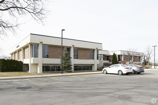
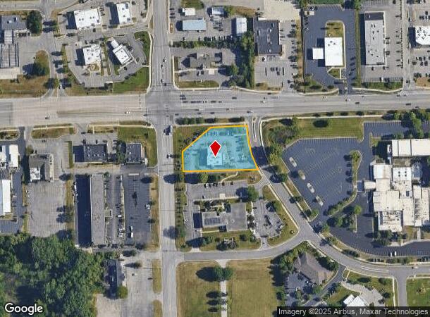
Property Record
5630 28Th St Se, Grand Rapids, MI 49546

NEARBY LISTINGS FOR SALE OR LEASE
Property Detail
5630 28Th St Se
Grand Rapids-Wyoming, MI
Foremost Centennial Park No.2
41-19-17-101-012
LOT 20 * FOREMOST CENTENNIAL PARK NO.2
Commercialnec
Kent
X
Michigan
26081C0442D
20
2024
1.08 AC
2025
SE Grand Rapids/Cascade
012203
West Michigan
4,458 SF
DEMOGRAPHICS near 5630 28Th St Se
1 Mile
3 Mile
5 Mile
2024 Total Population
3,083
34,075
96,023
2029 Population
3,101
34,398
96,927
Pop Growth 2024-2029
+ 0.58%
+ 0.95%
+ 0.94%
Average Age
46
39
40
2024 Total Households
1,394
13,128
37,029
HH Growth 2024-2029
+ 0.50%
+ 1.00%
+ 0.93%
Median Household Inc
$90,920
$87,605
$88,075
Avg Household Size
2.20
2.50
2.50
2024 Avg HH Vehicles
2.00
2.00
2.00
Median Home Value
$311,922
$368,133
$320,064
Median Year Built
1986
1985
1982
Nearby Places
Map Layers
Map Styles
 Street
 Aerial
- Restaurants
- Banks
- Shops
- Fitness
- Groceries
PUBLIC TRANSPORTATION
AIRPORT
Gerald R Ford International
DRIVE
WALK
Distance
Gerald R Ford International
13 min
5.9 mi
Freight Ports
Port Milwaukee
DRIVE
WALK
Distance
Port Milwaukee
317 min
271.1 mi
SALE & LEASE HISTORY
LISTING DATE
SALE/LEASE

Sep 25, 2016
For Lease
Nearby Properties
Address
Land Use
TOTAL SIZE
Lot Size
Zoning
Address
Land Use
TOTAL SIZE
Lot Size
Zoning
476,572 SF
51.60 AC
R4
Address
Land Use
TOTAL SIZE
Lot Size
Zoning
521,735 SF
52.16 AC
MON-C
Address
Land Use
TOTAL SIZE
Lot Size
Zoning
126,805 SF
9.36 AC
C4
Address
Land Use
TOTAL SIZE
Lot Size
Zoning
151,708 SF
7.22 AC
C4
Address
Land Use
TOTAL SIZE
Lot Size
Zoning
341,808 SF
27.73 AC
HC-PUD
Address
Land Use
TOTAL SIZE
Lot Size
Zoning
23.99 AC
PUD
Address
Land Use
TOTAL SIZE
Lot Size
Zoning
22.46 AC
MON-MDR
Address
Land Use
TOTAL SIZE
Lot Size
Zoning
226,877 SF
22.40 AC
R2
Address
Land Use
TOTAL SIZE
Lot Size
Zoning
19.40 AC
MON-MDR
Address
Land Use
TOTAL SIZE
Lot Size
Zoning
127,141 SF
17.04 AC
C2
Address
Land Use
TOTAL SIZE
Lot Size
Zoning
455,880 SF
24.91 AC
I1
Address
Land Use
TOTAL SIZE
Lot Size
Zoning
285,875 SF
37.86 AC
TI
Address
Land Use
TOTAL SIZE
Lot Size
Zoning
400,646 SF
23.78 AC
I1
Address
Land Use
TOTAL SIZE
Lot Size
Zoning
97,263 SF
19.37 AC
MON-MDR
Address
Land Use
TOTAL SIZE
Lot Size
Zoning
330,346 SF
49.71 AC
I1
Address
Land Use
TOTAL SIZE
Lot Size
Zoning
304,200 SF
R1
Address
Land Use
TOTAL SIZE
Lot Size
Zoning
16.91 AC
MON-MDR
Address
Land Use
TOTAL SIZE
Lot Size
Zoning
183,583 SF
9.12 AC
R-1
Address
Land Use
TOTAL SIZE
Lot Size
Zoning
619,165 SF
37 AC
I1
Address
Land Use
TOTAL SIZE
Lot Size
Zoning
51,148 SF
26.38 AC
R-PUD-1
Address
Land Use
TOTAL SIZE
Lot Size
Zoning
184,186 SF
19.24 AC
R4
Address
Land Use
TOTAL SIZE
Lot Size
Zoning
209,417 SF
19.51 AC
C4
Address
Land Use
TOTAL SIZE
Lot Size
Zoning
140,700 SF
15.45 AC
R4
Address
Land Use
TOTAL SIZE
Lot Size
Zoning
18.86 AC
MON-MDR
Address
Land Use
TOTAL SIZE
Lot Size
Zoning
23.01 AC
MON-MDR
Address
Land Use
TOTAL SIZE
Lot Size
Zoning
236,061 SF
11.09 AC
PUD
Address
Land Use
TOTAL SIZE
Lot Size
Zoning
529,904 SF
20.04 AC
I1
Address
Land Use
TOTAL SIZE
Lot Size
Zoning
9.94 AC
MON-MDR
Address
Land Use
TOTAL SIZE
Lot Size
Zoning
45,075 SF
20.54 AC
C2
Address
Land Use
TOTAL SIZE
Lot Size
Zoning
362,686 SF
20.99 AC
TI
The World's #1 Commercial Real Estate Marketplace
Connect with us
© 2025 CoStar Group
The information above has been obtained from sources believed reliable. While we do not doubt its accuracy we have not verified it and make no guarantee, warranty or representation about it. It is your responsibility to independently confirm its accuracy and completeness. Any projections, opinions, assumptions, or estimates used are for example only and do not represent the current or future performance of the property. The value of this transaction to you depends on tax and other factors which should be evaluated by your tax, financial, and legal advisors. You and your advisors should conduct a careful, independent investigation of the property to determine to your satisfaction the suitability of the property for your needs.