Property Record
5635 Riverdale Dr, Jamestown, NC 27282

NEARBY LISTINGS FOR SALE OR LEASE
-
-
View all Jamestown listings for sale on LoopNet.com
Property Detail
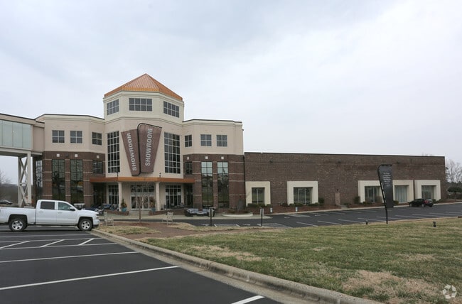
5635 Riverdale Dr
Greensboro-High Point, NC
Furnitureland S Inc Map
0160995
FURNITURELAND SOUTH PL:167-122
Storebuilding
Guilford
X
North Carolina
3710782000J
15
2024
46.12 AC
2025
High Point/SW Guilford Cty
016410
Greensboro/Winston-Salem
84,029 SF
DEMOGRAPHICS near 5635 Riverdale Dr
1 Mile
3 Mile
5 Mile
2024 Total Population
1,944
21,312
96,346
2029 Population
1,926
21,309
96,562
Pop Growth 2024-2029
(0.93%)
(0.01%)
+ 0.22%
Average Age
39
42
39
2024 Total Households
739
8,500
37,423
HH Growth 2024-2029
(0.95%)
+ 0.01%
+ 0.23%
Median Household Inc
$64,364
$64,961
$57,326
Avg Household Size
2.60
2.50
2.40
2024 Avg HH Vehicles
2.00
2.00
2.00
Median Home Value
$151,780
$176,165
$182,041
Median Year Built
1988
1981
1985
Nearby Places
Map Layers
Map Styles
 Street
 Aerial
- Restaurants
- Banks
- Shops
- Fitness
- Groceries
PUBLIC TRANSPORTATION
COMMUTER RAIL
High Point Station (Piedmont - North Carolina by Train (NC Train))
DRIVE
WALK
Distance
High Point Station (Piedmont - North Carolina by Train (NC Train))
11 min
6.6 mi
AIRPORT
Piedmont Triad International
DRIVE
WALK
Distance
Piedmont Triad International
28 min
16.9 mi
Nearby Properties
Address
Land Use
TOTAL SIZE
Lot Size
Zoning
Address
Land Use
TOTAL SIZE
Lot Size
Zoning
341,210 SF
13.43 AC
PUD
Address
Land Use
TOTAL SIZE
Lot Size
Zoning
419,281 SF
25.12 AC
CIV
Address
Land Use
TOTAL SIZE
Lot Size
Zoning
805,958 SF
61.42 AC
LI
Address
Land Use
TOTAL SIZE
Lot Size
Zoning
231,597 SF
8.46 AC
PD-R
Address
Land Use
TOTAL SIZE
Lot Size
Zoning
395,043 SF
15.74 AC
PUD
Address
Land Use
TOTAL SIZE
Lot Size
Zoning
30,322 SF
964.25 AC
PNR
Address
Land Use
TOTAL SIZE
Lot Size
Zoning
299,349 SF
21.76 AC
RM-16
Address
Land Use
TOTAL SIZE
Lot Size
Zoning
403,590 SF
72.06 AC
CIV
Address
Land Use
TOTAL SIZE
Lot Size
Zoning
144,746 SF
8.17 AC
AG
Address
Land Use
TOTAL SIZE
Lot Size
Zoning
324,986 SF
24.19 AC
LI
Address
Land Use
TOTAL SIZE
Lot Size
Zoning
473,040 SF
63.60 AC
AG
Address
Land Use
TOTAL SIZE
Lot Size
Zoning
272,917 SF
33.57 AC
MS
Address
Land Use
TOTAL SIZE
Lot Size
Zoning
72,851 SF
9.13 AC
IND
Address
Land Use
TOTAL SIZE
Lot Size
Zoning
113,866 SF
11.53 AC
LI
Address
Land Use
TOTAL SIZE
Lot Size
Zoning
79,740 SF
24.38 AC
R-5
Address
Land Use
TOTAL SIZE
Lot Size
Zoning
79,022 SF
6.52 AC
CIV
Address
Land Use
TOTAL SIZE
Lot Size
Zoning
89,183 SF
17.12 AC
GB
Address
Land Use
TOTAL SIZE
Lot Size
Zoning
64,721 SF
10.65 AC
AG
Address
Land Use
TOTAL SIZE
Lot Size
Zoning
63,326 SF
14.81 AC
CIV
Address
Land Use
TOTAL SIZE
Lot Size
Zoning
144,843 SF
22.14 AC
MS
Address
Land Use
TOTAL SIZE
Lot Size
Zoning
53,097 SF
6.36 AC
MS
Address
Land Use
TOTAL SIZE
Lot Size
Zoning
105,050 SF
9.58 AC
RM-16
Address
Land Use
TOTAL SIZE
Lot Size
Zoning
37,578 SF
36.11 AC
HI
Address
Land Use
TOTAL SIZE
Lot Size
Zoning
82,476 SF
5.37 AC
RM-8
Address
Land Use
TOTAL SIZE
Lot Size
Zoning
67,700 SF
10.75 AC
RM-16
Address
Land Use
TOTAL SIZE
Lot Size
Zoning
13,311 SF
162.92 AC
HI
Address
Land Use
TOTAL SIZE
Lot Size
Zoning
150.47 AC
PD-R
Address
Land Use
TOTAL SIZE
Lot Size
Zoning
65,733 SF
124.36 AC
HI
Address
Land Use
TOTAL SIZE
Lot Size
Zoning
51,175 SF
7.52 AC
CIV
The World's #1 Commercial Real Estate Marketplace
Connect with us
© 2025 CoStar Group
The information above has been obtained from sources believed reliable. While we do not doubt its accuracy we have not verified it and make no guarantee, warranty or representation about it. It is your responsibility to independently confirm its accuracy and completeness. Any projections, opinions, assumptions, or estimates used are for example only and do not represent the current or future performance of the property. The value of this transaction to you depends on tax and other factors which should be evaluated by your tax, financial, and legal advisors. You and your advisors should conduct a careful, independent investigation of the property to determine to your satisfaction the suitability of the property for your needs.