Property Record
5638 Lower Valley Pike, Springfield, OH 45502


NEARBY LISTINGS FOR SALE OR LEASE
-
-
View all Springfield listings for sale on LoopNet.com
Property Detail
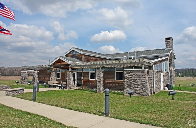
5638 Lower Valley Pike
01-00600-03300-0103
PT W 1/2 N W QR & PT E 1/2 N E QR (8)
Taxexempt
Clark
AE
Ohio
39023C0166E
103
2024
27.51 AC
2025
Northeast Dayton
002800
Cincinnati/Dayton
3,588 SF
Springfield, OH
DEMOGRAPHICS near 5638 Lower Valley Pike
1 Mile
3 Mile
5 Mile
2024 Total Population
407
9,497
28,663
2029 Population
402
9,404
28,464
Pop Growth 2024-2029
(1.23%)
(0.98%)
(0.69%)
Average Age
44
43
43
2024 Total Households
160
3,769
11,624
HH Growth 2024-2029
(1.25%)
(0.93%)
(0.67%)
Median Household Inc
$93,999
$79,382
$70,010
Avg Household Size
2.50
2.50
2.40
2024 Avg HH Vehicles
3.00
2.00
2.00
Median Home Value
$263,461
$178,540
$171,426
Median Year Built
1966
1965
1965
Nearby Places
Map Layers
Map Styles
 Street
 Aerial
- Restaurants
- Banks
- Shops
- Fitness
- Groceries
PUBLIC TRANSPORTATION
AIRPORT
James M Cox Dayton International
DRIVE
WALK
Distance
James M Cox Dayton International
29 min
20.7 mi
Nearby Properties
Address
Land Use
TOTAL SIZE
Lot Size
Zoning
Address
Land Use
TOTAL SIZE
Lot Size
Zoning
6,495 SF
38.20 AC
Address
Land Use
TOTAL SIZE
Lot Size
Zoning
144,644 SF
38.20 AC
I-1
Address
Land Use
TOTAL SIZE
Lot Size
Zoning
20,982 SF
19.65 AC
Address
Land Use
TOTAL SIZE
Lot Size
Zoning
84,432 SF
13.39 AC
I-1
Address
Land Use
TOTAL SIZE
Lot Size
Zoning
2.94 AC
Address
Land Use
TOTAL SIZE
Lot Size
Zoning
40,000 SF
10.41 AC
I-1
Address
Land Use
TOTAL SIZE
Lot Size
Zoning
265.13 AC
A-1
Address
Land Use
TOTAL SIZE
Lot Size
Zoning
11,121 SF
1.69 AC
Address
Land Use
TOTAL SIZE
Lot Size
Zoning
43.31 AC
Address
Land Use
TOTAL SIZE
Lot Size
Zoning
32,788 SF
7.58 AC
Address
Land Use
TOTAL SIZE
Lot Size
Zoning
Address
Land Use
TOTAL SIZE
Lot Size
Zoning
4,356 SF
201.93 AC
A1
Address
Land Use
TOTAL SIZE
Lot Size
Zoning
202.42 AC
A-1
Address
Land Use
TOTAL SIZE
Lot Size
Zoning
102,224 SF
12.10 AC
Address
Land Use
TOTAL SIZE
Lot Size
Zoning
52,498 SF
20.32 AC
B-4
Address
Land Use
TOTAL SIZE
Lot Size
Zoning
7,304 SF
142.87 AC
A-1
Address
Land Use
TOTAL SIZE
Lot Size
Zoning
7,262 SF
88.50 AC
A-1
Address
Land Use
TOTAL SIZE
Lot Size
Zoning
7.16 AC
Address
Land Use
TOTAL SIZE
Lot Size
Zoning
4,868 SF
129.27 AC
A-1
Address
Land Use
TOTAL SIZE
Lot Size
Zoning
3,488 SF
133.33 AC
A-1
Address
Land Use
TOTAL SIZE
Lot Size
Zoning
1,750 SF
146.40 AC
A-1
Address
Land Use
TOTAL SIZE
Lot Size
Zoning
7,766 SF
89.49 AC
A-1
Address
Land Use
TOTAL SIZE
Lot Size
Zoning
2,264 SF
141.14 AC
R-1
Address
Land Use
TOTAL SIZE
Lot Size
Zoning
139.92 AC
A-1
Address
Land Use
TOTAL SIZE
Lot Size
Zoning
5,760 SF
85 AC
A-1
Address
Land Use
TOTAL SIZE
Lot Size
Zoning
22,970 SF
20.28 AC
A
Address
Land Use
TOTAL SIZE
Lot Size
Zoning
1,536 SF
112.29 AC
A-1
Address
Land Use
TOTAL SIZE
Lot Size
Zoning
111.42 AC
A-1
Address
Land Use
TOTAL SIZE
Lot Size
Zoning
3,432 SF
106.22 AC
A-1
The World's #1 Commercial Real Estate Marketplace
Connect with us
© 2025 CoStar Group
The information above has been obtained from sources believed reliable. While we do not doubt its accuracy we have not verified it and make no guarantee, warranty or representation about it. It is your responsibility to independently confirm its accuracy and completeness. Any projections, opinions, assumptions, or estimates used are for example only and do not represent the current or future performance of the property. The value of this transaction to you depends on tax and other factors which should be evaluated by your tax, financial, and legal advisors. You and your advisors should conduct a careful, independent investigation of the property to determine to your satisfaction the suitability of the property for your needs.