Property Record
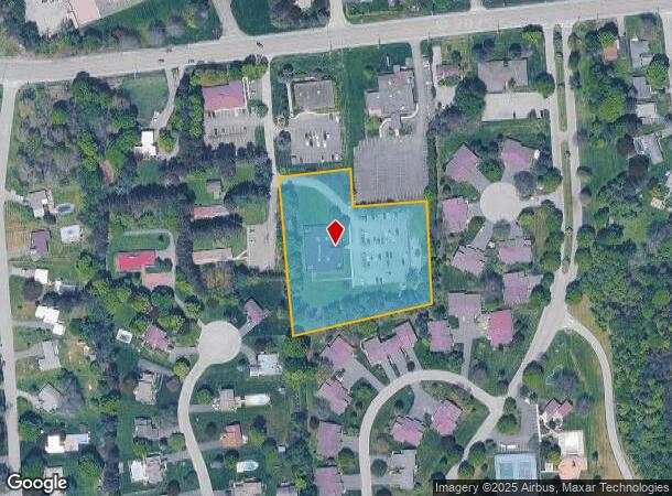
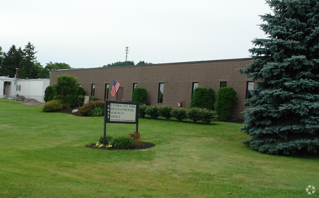
5639 W Genesee St, Camillus, NY 13031

NEARBY LISTINGS FOR SALE OR LEASE
Property Detail
5639 W Genesee St
Syracuse, NY
Top O' Hill
312089-029-000-0001-018-003-0000
TOP O' HILL SUBD LT 3
Professionalbldglegalinsurancerealestateetc
Onondaga
X
New York
36067C0191F
18.003
2025
2.89 AC
2024
W Outer Onondaga County
012300
Syracuse
10,070 SF
DEMOGRAPHICS near 5639 W Genesee St
1 Mile
3 Mile
5 Mile
2024 Total Population
5,772
22,716
55,224
2029 Population
5,617
22,092
53,836
Pop Growth 2024-2029
(2.69%)
(2.75%)
(2.51%)
Average Age
44
44
43
2024 Total Households
2,554
9,765
23,178
HH Growth 2024-2029
(2.86%)
(2.96%)
(2.71%)
Median Household Inc
$81,423
$81,879
$78,623
Avg Household Size
2.20
2.30
2.30
2024 Avg HH Vehicles
2.00
2.00
2.00
Median Home Value
$182,570
$179,003
$178,261
Median Year Built
1962
1964
1961
Nearby Places
- Restaurants
- Banks
- Shops
- Fitness
- Groceries
PUBLIC TRANSPORTATION
COMMUTER RAIL
DRIVE
WALK
Distance
10 min
5.1 mi
AIRPORT
Syracuse Hancock International
DRIVE
WALK
Distance
Syracuse Hancock International
26 min
14.9 mi
Nearby Properties
Address
Land Use
TOTAL SIZE
Lot Size
Zoning
Address
Land Use
TOTAL SIZE
Lot Size
Zoning
52,800 SF
691.95 AC
06 - INDUS
Address
Land Use
TOTAL SIZE
Lot Size
Zoning
256,000 SF
44.31 AC
08 - GOVER
Address
Land Use
TOTAL SIZE
Lot Size
Zoning
6,106 SF
32.71 AC
06
Address
Land Use
TOTAL SIZE
Lot Size
Zoning
22,692 SF
28.07 AC
03 - MULTI
Address
Land Use
TOTAL SIZE
Lot Size
Zoning
109,800 SF
111.52 AC
08 - GOVER
Address
Land Use
TOTAL SIZE
Lot Size
Zoning
10,200 SF
5.96 AC
03 - MULTI
Address
Land Use
TOTAL SIZE
Lot Size
Zoning
205,018 SF
18.15 AC
05 - COMME
Address
Land Use
TOTAL SIZE
Lot Size
Zoning
127,391 SF
11.68 AC
05 - COMME
Address
Land Use
TOTAL SIZE
Lot Size
Zoning
3,136 SF
16.30 AC
03 - MULTI
Address
Land Use
TOTAL SIZE
Lot Size
Zoning
121,941 SF
30.34 AC
08 - GOVER
Address
Land Use
TOTAL SIZE
Lot Size
Zoning
104,592 SF
20.41 AC
08 - GOVER
Address
Land Use
TOTAL SIZE
Lot Size
Zoning
55,243 SF
9.25 AC
05 - COMME
Address
Land Use
TOTAL SIZE
Lot Size
Zoning
12,325 SF
16.12 AC
07 - MIXED
Address
Land Use
TOTAL SIZE
Lot Size
Zoning
157,675 SF
12.88 AC
Address
Land Use
TOTAL SIZE
Lot Size
Zoning
254,436 SF
21.94 AC
06 - INDUS
Address
Land Use
TOTAL SIZE
Lot Size
Zoning
138,735 SF
13.81 AC
05 - COMME
Address
Land Use
TOTAL SIZE
Lot Size
Zoning
78,545 SF
8.55 AC
05 - COMME
Address
Land Use
TOTAL SIZE
Lot Size
Zoning
13,032 SF
7.63 AC
Address
Land Use
TOTAL SIZE
Lot Size
Zoning
15,060 SF
3.10 AC
05 - COMME
Address
Land Use
TOTAL SIZE
Lot Size
Zoning
114,396 SF
9.98 AC
05 - COMME
Address
Land Use
TOTAL SIZE
Lot Size
Zoning
10,560 SF
8.97 AC
03 - MULTI
Address
Land Use
TOTAL SIZE
Lot Size
Zoning
118,035 SF
26.43 AC
07 - MIXED
Address
Land Use
TOTAL SIZE
Lot Size
Zoning
72,768 SF
2.70 AC
6
Address
Land Use
TOTAL SIZE
Lot Size
Zoning
3.79 AC
02 - SINGL
Address
Land Use
TOTAL SIZE
Lot Size
Zoning
43,664 SF
1.87 AC
Address
Land Use
TOTAL SIZE
Lot Size
Zoning
2,028 SF
9.60 AC
05 - COMME
Address
Land Use
TOTAL SIZE
Lot Size
Zoning
48,147 SF
5.17 AC
05 - COMME
Address
Land Use
TOTAL SIZE
Lot Size
Zoning
7,853 SF
28.03 AC
6
Address
Land Use
TOTAL SIZE
Lot Size
Zoning
3,721 SF
12.95 AC
02 - SINGL
Address
Land Use
TOTAL SIZE
Lot Size
Zoning
4.38 AC
02 - SINGL
The World's #1 Commercial Real Estate Marketplace
Connect with us
© 2025 CoStar Group
The information above has been obtained from sources believed reliable. While we do not doubt its accuracy we have not verified it and make no guarantee, warranty or representation about it. It is your responsibility to independently confirm its accuracy and completeness. Any projections, opinions, assumptions, or estimates used are for example only and do not represent the current or future performance of the property. The value of this transaction to you depends on tax and other factors which should be evaluated by your tax, financial, and legal advisors. You and your advisors should conduct a careful, independent investigation of the property to determine to your satisfaction the suitability of the property for your needs.