Property Record
564A Route 9, West Chesterfield, NH 03466


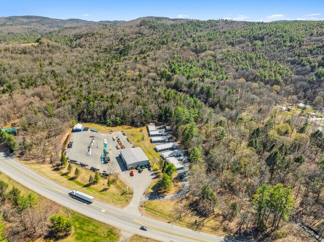
This Property Is For Sale
NEARBY LISTINGS FOR SALE OR LEASE
-
-
View all West Chesterfield listings for sale on LoopNet.com
Property Detail
564A Route 9
Commercialnec
Cheshire
A
New Hampshire
33005C0219E
2.50 AC
2024
Manchester/New Hampshire South Area
2024
Other Market Areas
971500
Keene, NH
1,950 SF
CHFD M:13 B:G002
DEMOGRAPHICS near 564A Route 9
1 Mile
3 Mile
5 Mile
2024 Total Population
441
2,537
13,142
2029 Population
465
2,642
13,487
Pop Growth 2024-2029
+ 5.44%
+ 4.14%
+ 2.63%
Average Age
47
47
45
2024 Total Households
180
1,061
6,151
HH Growth 2024-2029
+ 5.56%
+ 4.15%
+ 2.68%
Median Household Inc
$137,500
$112,916
$67,704
Avg Household Size
2.50
2.40
2.00
2024 Avg HH Vehicles
2.00
2.00
2.00
Median Home Value
$415,000
$404,657
$304,985
Median Year Built
1972
1972
1966
Nearby Places
Map Layers
Map Styles
 Street
 Aerial
- Restaurants
- Banks
- Shops
- Fitness
- Groceries
PUBLIC TRANSPORTATION
COMMUTER RAIL
Brattleboro Amtrak Station (Vermonter - Amtrak)
DRIVE
WALK
Distance
Brattleboro Amtrak Station (Vermonter - Amtrak)
12 min
5.6 mi
Freight Ports
Albany, NY Port
DRIVE
WALK
Distance
Albany, NY Port
138 min
86.3 mi
Nearby Properties
Address
Land Use
TOTAL SIZE
Lot Size
Zoning
Address
Land Use
TOTAL SIZE
Lot Size
Zoning
63.75 AC
I / IN
Address
Land Use
TOTAL SIZE
Lot Size
Zoning
Address
Land Use
TOTAL SIZE
Lot Size
Zoning
29,829 SF
31.93 AC
COMM/I
Address
Land Use
TOTAL SIZE
Lot Size
Zoning
15.56 AC
C / CO
Address
Land Use
TOTAL SIZE
Lot Size
Zoning
7,096 SF
8 AC
RESIDE
Address
Land Use
TOTAL SIZE
Lot Size
Zoning
5 AC
C / CO
Address
Land Use
TOTAL SIZE
Lot Size
Zoning
163,367 SF
39.52 AC
I / IN
Address
Land Use
TOTAL SIZE
Lot Size
Zoning
11,436 SF
1.92 AC
C
Address
Land Use
TOTAL SIZE
Lot Size
Zoning
3.93 AC
C
Address
Land Use
TOTAL SIZE
Lot Size
Zoning
7,304 SF
3.40 AC
COMM/I
Address
Land Use
TOTAL SIZE
Lot Size
Zoning
46,291 SF
2.61 AC
COMM/I
Address
Land Use
TOTAL SIZE
Lot Size
Zoning
35 AC
I / IN
Address
Land Use
TOTAL SIZE
Lot Size
Zoning
19.55 AC
I
Address
Land Use
TOTAL SIZE
Lot Size
Zoning
56,778 SF
24.33 AC
COMM/I
Address
Land Use
TOTAL SIZE
Lot Size
Zoning
2,295.68 AC
RURAL/
Address
Land Use
TOTAL SIZE
Lot Size
Zoning
15,707 SF
88.40 AC
RURAL/
Address
Land Use
TOTAL SIZE
Lot Size
Zoning
7.39 AC
C
Address
Land Use
TOTAL SIZE
Lot Size
Zoning
14.13 AC
PU
Address
Land Use
TOTAL SIZE
Lot Size
Zoning
Address
Land Use
TOTAL SIZE
Lot Size
Zoning
3.70 AC
C
Address
Land Use
TOTAL SIZE
Lot Size
Zoning
299,150 SF
18.15 AC
I
Address
Land Use
TOTAL SIZE
Lot Size
Zoning
7.97 AC
I
Address
Land Use
TOTAL SIZE
Lot Size
Zoning
6,634 SF
0.83 AC
C / CO
Address
Land Use
TOTAL SIZE
Lot Size
Zoning
3.54 AC
C
Address
Land Use
TOTAL SIZE
Lot Size
Zoning
12,366 SF
2.35 AC
C / CO
Address
Land Use
TOTAL SIZE
Lot Size
Zoning
22,562 SF
4.12 AC
C / CO
Address
Land Use
TOTAL SIZE
Lot Size
Zoning
7,440 SF
3.16 AC
C
Address
Land Use
TOTAL SIZE
Lot Size
Zoning
20,720 SF
2.24 AC
C
Address
Land Use
TOTAL SIZE
Lot Size
Zoning
27,415 SF
7.02 AC
COMM/I
Address
Land Use
TOTAL SIZE
Lot Size
Zoning
10,680 SF
1.88 AC
C / CO
The World's #1 Commercial Real Estate Marketplace
Connect with us
© 2025 CoStar Group
The information above has been obtained from sources believed reliable. While we do not doubt its accuracy we have not verified it and make no guarantee, warranty or representation about it. It is your responsibility to independently confirm its accuracy and completeness. Any projections, opinions, assumptions, or estimates used are for example only and do not represent the current or future performance of the property. The value of this transaction to you depends on tax and other factors which should be evaluated by your tax, financial, and legal advisors. You and your advisors should conduct a careful, independent investigation of the property to determine to your satisfaction the suitability of the property for your needs.