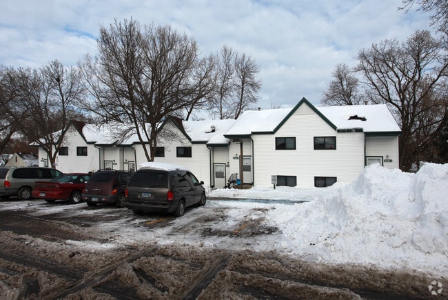
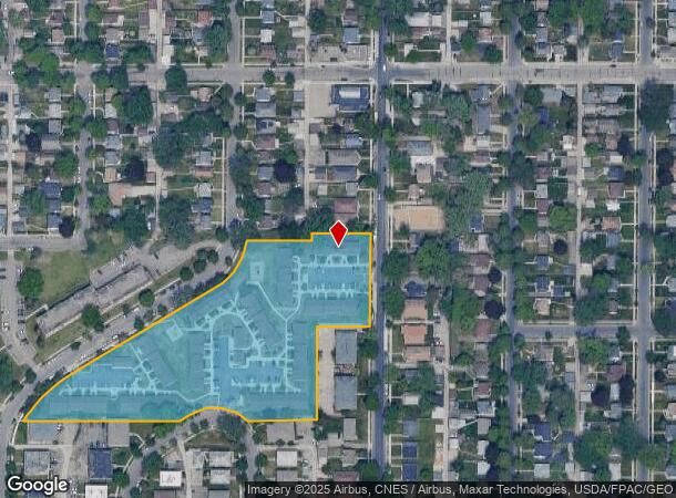
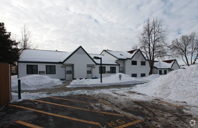
Property Record
5640 34Th Ave S, Minneapolis, MN 55417
NEARBY LISTINGS FOR SALE OR LEASE
Property Detail
5640 34Th Ave S
19-028-23-23-0003
Unplatted
Governmentalpublicusegeneral
UNPLATTED THAT PART OF S 467.42 FT OF N 859.46 FT OF SW 1/4 OF NW 1/4 OF SEC 19 T 28 R 23 WHICH LIES E OF BOSSEN TERRACE EXCEPT E 164 FT OF S 235 FT THOF AND T IRREGULAR
X
Hennepin
27053C0388F
Minnesota
2024
5.18 AC
2024
Wenonah
012101
Minneapolis/St Paul
22,300 SF
Minneapolis-St. Paul-Bloomington, MN-WI
DEMOGRAPHICS near 5640 34Th Ave S
1 Mile
3 Mile
5 Mile
2024 Total Population
12,257
107,978
359,545
2029 Population
12,014
106,136
353,203
Pop Growth 2024-2029
(1.98%)
(1.71%)
(1.76%)
Average Age
40
40
39
2024 Total Households
5,415
45,688
153,596
HH Growth 2024-2029
(2.16%)
(1.80%)
(1.86%)
Median Household Inc
$93,436
$89,791
$74,976
Avg Household Size
2.20
2.30
2.20
2024 Avg HH Vehicles
2.00
2.00
2.00
Median Home Value
$285,029
$327,629
$340,356
Median Year Built
1948
1949
1951
Nearby Places
Map Layers
Map Styles
 Street
 Aerial
- Restaurants
- Banks
- Shops
- Fitness
- Groceries
PUBLIC TRANSPORTATION
COMMUTER RAIL
St. Paul-Minneapolis (Empire Builder - Amtrak)
DRIVE
WALK
Distance
St. Paul-Minneapolis (Empire Builder - Amtrak)
15 min
9.4 mi
Target Field Station (Northstar Corridor - Northstar Commuter Rail)
DRIVE
WALK
Distance
Target Field Station (Northstar Corridor - Northstar Commuter Rail)
17 min
9.8 mi
AIRPORT
Minneapolis-St Paul International/Wold-Chamberlain
DRIVE
WALK
Distance
Minneapolis-St Paul International/Wold-Chamberlain
9 min
4.8 mi
Freight Ports
Port Milwaukee
DRIVE
WALK
Distance
Port Milwaukee
375 min
338.0 mi
Nearby Properties
Address
Land Use
TOTAL SIZE
Lot Size
Zoning
Address
Land Use
TOTAL SIZE
Lot Size
Zoning
504,049 SF
75.43 AC
Address
Land Use
TOTAL SIZE
Lot Size
Zoning
3.86 AC
Address
Land Use
TOTAL SIZE
Lot Size
Zoning
2.65 AC
Address
Land Use
TOTAL SIZE
Lot Size
Zoning
Address
Land Use
TOTAL SIZE
Lot Size
Zoning
429,720 SF
6.02 AC
Address
Land Use
TOTAL SIZE
Lot Size
Zoning
Address
Land Use
TOTAL SIZE
Lot Size
Zoning
33,246 SF
5.16 AC
Address
Land Use
TOTAL SIZE
Lot Size
Zoning
378,880 SF
3.42 AC
Address
Land Use
TOTAL SIZE
Lot Size
Zoning
47,397 SF
6.78 AC
Address
Land Use
TOTAL SIZE
Lot Size
Zoning
288,834 SF
1.72 AC
Address
Land Use
TOTAL SIZE
Lot Size
Zoning
2.18 AC
Address
Land Use
TOTAL SIZE
Lot Size
Zoning
Address
Land Use
TOTAL SIZE
Lot Size
Zoning
Address
Land Use
TOTAL SIZE
Lot Size
Zoning
34,152 SF
6.11 AC
Address
Land Use
TOTAL SIZE
Lot Size
Zoning
26,838 SF
1.30 AC
Address
Land Use
TOTAL SIZE
Lot Size
Zoning
254,517 SF
2.22 AC
C3A
Address
Land Use
TOTAL SIZE
Lot Size
Zoning
Address
Land Use
TOTAL SIZE
Lot Size
Zoning
Address
Land Use
TOTAL SIZE
Lot Size
Zoning
Address
Land Use
TOTAL SIZE
Lot Size
Zoning
165,618 SF
12.37 AC
Address
Land Use
TOTAL SIZE
Lot Size
Zoning
223,680 SF
2.61 AC
R5
Address
Land Use
TOTAL SIZE
Lot Size
Zoning
196,178 SF
1.26 AC
C3A
Address
Land Use
TOTAL SIZE
Lot Size
Zoning
305,011 SF
8.61 AC
Address
Land Use
TOTAL SIZE
Lot Size
Zoning
Address
Land Use
TOTAL SIZE
Lot Size
Zoning
5.24 AC
Address
Land Use
TOTAL SIZE
Lot Size
Zoning
169,522 SF
1.45 AC
C3A
Address
Land Use
TOTAL SIZE
Lot Size
Zoning
3.21 AC
Address
Land Use
TOTAL SIZE
Lot Size
Zoning
Address
Land Use
TOTAL SIZE
Lot Size
Zoning
207,621 SF
1.65 AC
Address
Land Use
TOTAL SIZE
Lot Size
Zoning
86,188 SF
6.13 AC
R5
The World's #1 Commercial Real Estate Marketplace
Connect with us
© 2025 CoStar Group
The information above has been obtained from sources believed reliable. While we do not doubt its accuracy we have not verified it and make no guarantee, warranty or representation about it. It is your responsibility to independently confirm its accuracy and completeness. Any projections, opinions, assumptions, or estimates used are for example only and do not represent the current or future performance of the property. The value of this transaction to you depends on tax and other factors which should be evaluated by your tax, financial, and legal advisors. You and your advisors should conduct a careful, independent investigation of the property to determine to your satisfaction the suitability of the property for your needs.