Property Record
5640 Whitelock Pky, Elk Grove, CA 95757


NEARBY LISTINGS FOR SALE OR LEASE
Property Detail
5640 Whitelock Pky
Sacramento--Roseville--Arden-Arcade, CA
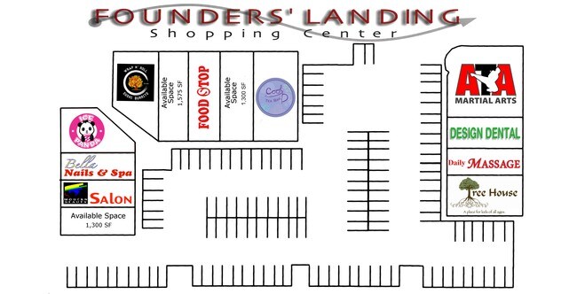
Gilliam Meadows Unit1
132-1430-002
GILLIAM MEADOWS UNIT1, LOT 2
Regionalshoppingcenterormallwithanchorstore
Sacramento
X
California
06067C0318H
2
2024
2.83 AC
2025
Elk Grove
009647
Sacramento
21,600 SF
DEMOGRAPHICS near 5640 Whitelock Pky
1 Mile
3 Mile
5 Mile
2024 Total Population
27,462
104,337
193,386
2029 Population
27,621
105,227
195,010
Pop Growth 2024-2029
+ 0.58%
+ 0.85%
+ 0.84%
Average Age
37
39
38
2024 Total Households
7,597
32,970
60,019
HH Growth 2024-2029
+ 0.54%
+ 0.83%
+ 0.79%
Median Household Inc
$114,859
$110,933
$104,358
Avg Household Size
3.50
3.10
3.10
2024 Avg HH Vehicles
3.00
2.00
2.00
Median Home Value
$613,924
$564,119
$508,387
Median Year Built
2005
2001
1998
Nearby Places
Map Layers
Map Styles
 Street
 Aerial
- Restaurants
- Banks
- Shops
- Fitness
- Groceries
PUBLIC TRANSPORTATION
AIRPORT
Sacramento International
DRIVE
WALK
Distance
Sacramento International
38 min
27.4 mi
Nearby Properties
Address
Land Use
TOTAL SIZE
Lot Size
Zoning
Address
Land Use
TOTAL SIZE
Lot Size
Zoning
468,870 SF
26.55 AC
RD-20
Address
Land Use
TOTAL SIZE
Lot Size
Zoning
265,222 SF
14.42 AC
RD-20
Address
Land Use
TOTAL SIZE
Lot Size
Zoning
268,881 SF
12.25 AC
RD-20
Address
Land Use
TOTAL SIZE
Lot Size
Zoning
359,648 SF
17.23 AC
RD-25
Address
Land Use
TOTAL SIZE
Lot Size
Zoning
7.65 AC
RD-20
Address
Land Use
TOTAL SIZE
Lot Size
Zoning
Address
Land Use
TOTAL SIZE
Lot Size
Zoning
4.98 AC
RD-20
Address
Land Use
TOTAL SIZE
Lot Size
Zoning
102,085 SF
10.26 AC
BP
Address
Land Use
TOTAL SIZE
Lot Size
Zoning
152,217 SF
17.42 AC
SC
Address
Land Use
TOTAL SIZE
Lot Size
Zoning
9.02 AC
SPASEPA
Address
Land Use
TOTAL SIZE
Lot Size
Zoning
192,518 SF
8.97 AC
RD-20
Address
Land Use
TOTAL SIZE
Lot Size
Zoning
242,577 SF
0.10 AC
RD-20
Address
Land Use
TOTAL SIZE
Lot Size
Zoning
105,511 SF
4.79 AC
BP
Address
Land Use
TOTAL SIZE
Lot Size
Zoning
105,511 SF
6.67 AC
BP
Address
Land Use
TOTAL SIZE
Lot Size
Zoning
195,101 SF
12.21 AC
BP
Address
Land Use
TOTAL SIZE
Lot Size
Zoning
76,090 SF
3.32 AC
RD-25
Address
Land Use
TOTAL SIZE
Lot Size
Zoning
108,843 SF
4.14 AC
RD-30
Address
Land Use
TOTAL SIZE
Lot Size
Zoning
185,300 SF
11.63 AC
RD-20
Address
Land Use
TOTAL SIZE
Lot Size
Zoning
3.88 AC
RD-20
Address
Land Use
TOTAL SIZE
Lot Size
Zoning
83,274 SF
9.14 AC
SC
Address
Land Use
TOTAL SIZE
Lot Size
Zoning
221,954 SF
7.71 AC
RD-15
Address
Land Use
TOTAL SIZE
Lot Size
Zoning
94,585 SF
5.73 AC
RD-30
Address
Land Use
TOTAL SIZE
Lot Size
Zoning
4.88 AC
RD-25
Address
Land Use
TOTAL SIZE
Lot Size
Zoning
91,226 SF
10.81 AC
SC
Address
Land Use
TOTAL SIZE
Lot Size
Zoning
79,156 SF
5.81 AC
SC
Address
Land Use
TOTAL SIZE
Lot Size
Zoning
110,372 SF
2.68 AC
BP
Address
Land Use
TOTAL SIZE
Lot Size
Zoning
65,148 SF
5.77 AC
GC
Address
Land Use
TOTAL SIZE
Lot Size
Zoning
7.84 AC
MP O
Address
Land Use
TOTAL SIZE
Lot Size
Zoning
66,793 SF
2.48 AC
SC
Address
Land Use
TOTAL SIZE
Lot Size
Zoning
68,190 SF
3.75 AC
BP
The World's #1 Commercial Real Estate Marketplace
Connect with us
© 2026 CoStar Group
The information above has been obtained from sources believed reliable. While we do not doubt its accuracy we have not verified it and make no guarantee, warranty or representation about it. It is your responsibility to independently confirm its accuracy and completeness. Any projections, opinions, assumptions, or estimates used are for example only and do not represent the current or future performance of the property. The value of this transaction to you depends on tax and other factors which should be evaluated by your tax, financial, and legal advisors. You and your advisors should conduct a careful, independent investigation of the property to determine to your satisfaction the suitability of the property for your needs.