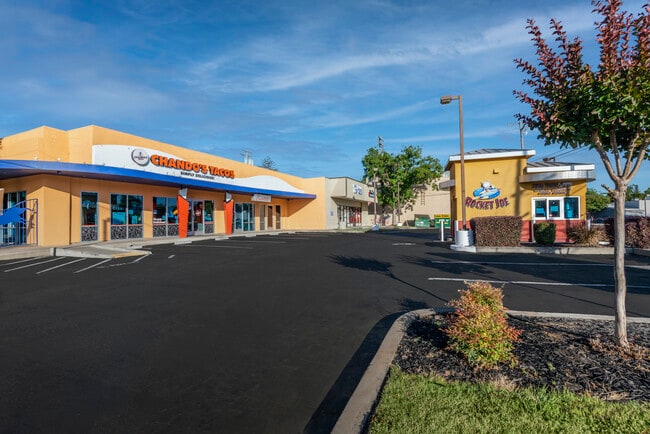
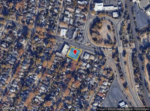
Property Record
5644 J St, Sacramento, CA 95819
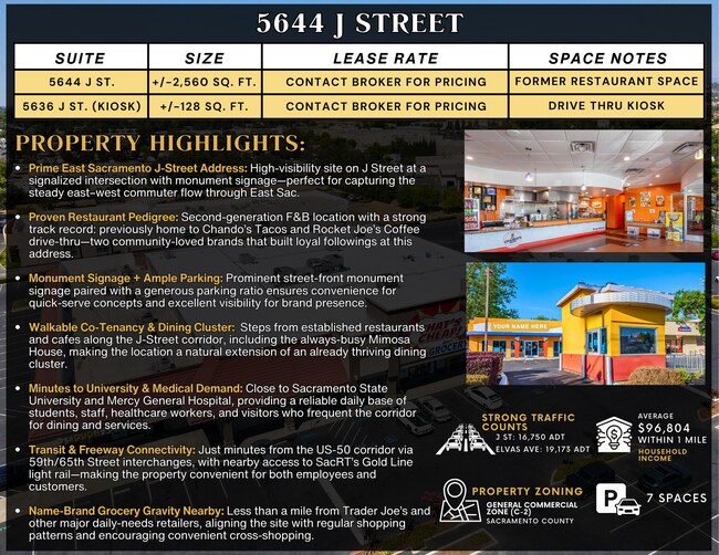

Current Lease Availabilities
NEARBY LISTINGS FOR SALE OR LEASE
Property Detail
5644 J St
Sacramento--Roseville--Arden-Arcade, CA
Smith 04
008-0182-024
LOTS 282 & 283 SMITH TRACT NO.4
Storebuilding
Sacramento
X
California
06067C0183H
283
2024
0.41 AC
2025
DTown/Midtown/E Sac
001601
Sacramento
5,098 SF
DEMOGRAPHICS near 5644 J St
1 Mile
3 Mile
5 Mile
2024 Total Population
16,120
163,810
417,400
2029 Population
16,336
165,740
421,446
Pop Growth 2024-2029
+ 1.34%
+ 1.18%
+ 0.97%
Average Age
41
38
38
2024 Total Households
6,782
72,153
162,919
HH Growth 2024-2029
+ 1.47%
+ 1.28%
+ 1.09%
Median Household Inc
$114,185
$70,978
$66,219
Avg Household Size
2.10
2.10
2.40
2024 Avg HH Vehicles
2.00
2.00
2.00
Median Home Value
$735,948
$523,848
$457,376
Median Year Built
1950
1963
1965
Nearby Places
- Restaurants
- Banks
- Shops
- Fitness
- Groceries
PUBLIC TRANSPORTATION
TRANSIT/SUBWAY
59Th Street (Gold Line - Sacramento Regional Transit District Light Rail (The RT))
DRIVE
WALK
Distance
59Th Street (Gold Line - Sacramento Regional Transit District Light Rail (The RT))
3 min
15 min
0.8 mi
University/65Th Street (Gold Line - Sacramento Regional Transit District Light Rail (The RT))
DRIVE
WALK
Distance
University/65Th Street (Gold Line - Sacramento Regional Transit District Light Rail (The RT))
2 min
19 min
1.0 mi
COMMUTER RAIL
Sacramento (Capitol Corridor - Capitol Corridor Joint Powers Authority)
DRIVE
WALK
Distance
Sacramento (Capitol Corridor - Capitol Corridor Joint Powers Authority)
10 min
4.7 mi
AIRPORT
Sacramento International
DRIVE
WALK
Distance
Sacramento International
25 min
15.3 mi
Freight Ports
Port of Stockton
DRIVE
WALK
Distance
Port of Stockton
61 min
50.3 mi
Nearby Properties
Address
Land Use
TOTAL SIZE
Lot Size
Zoning
Address
Land Use
TOTAL SIZE
Lot Size
Zoning
1,095,507 SF
1.39 AC
H-SPD C-2-
Address
Land Use
TOTAL SIZE
Lot Size
Zoning
10.28 AC
H
Address
Land Use
TOTAL SIZE
Lot Size
Zoning
7,742 SF
12.66 AC
M-1S-SWR
Address
Land Use
TOTAL SIZE
Lot Size
Zoning
299,943 SF
4.95 AC
H
Address
Land Use
TOTAL SIZE
Lot Size
Zoning
201,132 SF
28.11 AC
C-2
Address
Land Use
TOTAL SIZE
Lot Size
Zoning
1.33 AC
R-1
Address
Land Use
TOTAL SIZE
Lot Size
Zoning
756,831 SF
1.39 AC
C-2-SPD
Address
Land Use
TOTAL SIZE
Lot Size
Zoning
9.29 AC
R-1 OB-R-P
Address
Land Use
TOTAL SIZE
Lot Size
Zoning
1.15 AC
R-1
Address
Land Use
TOTAL SIZE
Lot Size
Zoning
490,607 SF
32.63 AC
RD-30
Address
Land Use
TOTAL SIZE
Lot Size
Zoning
200,616 SF
2.54 AC
C-2-SPD
Address
Land Use
TOTAL SIZE
Lot Size
Zoning
2.87 AC
C-2
Address
Land Use
TOTAL SIZE
Lot Size
Zoning
31,163 SF
1.57 AC
C-2-TO-SPD
Address
Land Use
TOTAL SIZE
Lot Size
Zoning
10.49 AC
C-2
Address
Land Use
TOTAL SIZE
Lot Size
Zoning
350,049 SF
8.51 AC
MRD-SWR
Address
Land Use
TOTAL SIZE
Lot Size
Zoning
319,856 SF
12.27 AC
R-3-R-PUD
Address
Land Use
TOTAL SIZE
Lot Size
Zoning
226,731 SF
15.73 AC
OB-PUD
Address
Land Use
TOTAL SIZE
Lot Size
Zoning
281,448 SF
13.42 AC
RMX-TO R-2
Address
Land Use
TOTAL SIZE
Lot Size
Zoning
0.65 AC
C-4-SPD
Address
Land Use
TOTAL SIZE
Lot Size
Zoning
390,860 SF
20.17 AC
R-3-R-PUD
Address
Land Use
TOTAL SIZE
Lot Size
Zoning
320,072 SF
2.65 AC
C-2
Address
Land Use
TOTAL SIZE
Lot Size
Zoning
383,000 SF
25.52 AC
M-1
Address
Land Use
TOTAL SIZE
Lot Size
Zoning
179,178 SF
3.35 AC
RO
Address
Land Use
TOTAL SIZE
Lot Size
Zoning
2.59 AC
OB-R
Address
Land Use
TOTAL SIZE
Lot Size
Zoning
122,425 SF
0.59 AC
C-2-SPD
Address
Land Use
TOTAL SIZE
Lot Size
Zoning
1.15 AC
R-1
Address
Land Use
TOTAL SIZE
Lot Size
Zoning
148,642 SF
7.15 AC
RD-30
Address
Land Use
TOTAL SIZE
Lot Size
Zoning
156,462 SF
8.36 AC
R-3
Address
Land Use
TOTAL SIZE
Lot Size
Zoning
280,519 SF
2.50 AC
C-2-SPD
Address
Land Use
TOTAL SIZE
Lot Size
Zoning
335,346 SF
16.65 AC
SC-R-PUD
The World's #1 Commercial Real Estate Marketplace
Connect with us
© 2025 CoStar Group
The information above has been obtained from sources believed reliable. While we do not doubt its accuracy we have not verified it and make no guarantee, warranty or representation about it. It is your responsibility to independently confirm its accuracy and completeness. Any projections, opinions, assumptions, or estimates used are for example only and do not represent the current or future performance of the property. The value of this transaction to you depends on tax and other factors which should be evaluated by your tax, financial, and legal advisors. You and your advisors should conduct a careful, independent investigation of the property to determine to your satisfaction the suitability of the property for your needs.