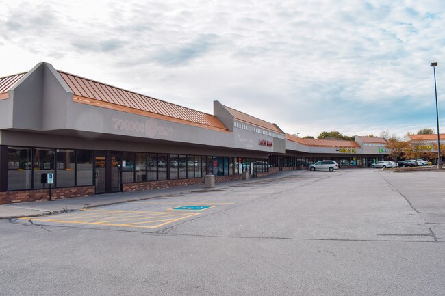
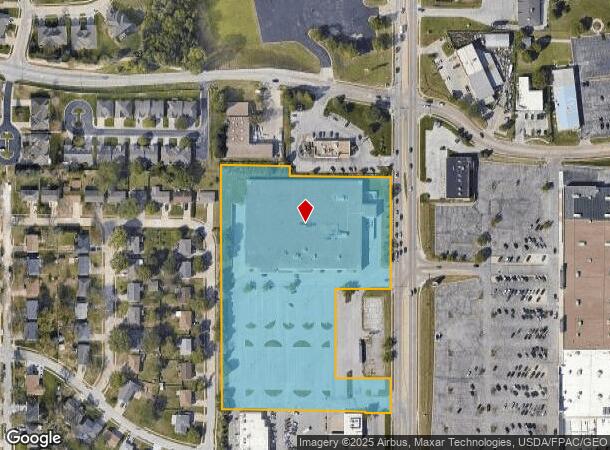
Property Record
5646 N 90Th St, Omaha, NE 68134
NEARBY LISTINGS FOR SALE OR LEASE
Property Detail
5646 N 90Th St
Omaha-Council Bluffs, NE-IA
Fort Division
3470-5025-11
FORT DIVISION REPLAT LOT 1 BLOCK 0 IRREG 308806 SQ FT
Publicstorage
Douglas
X
Nebraska
31055C0216H
1
2024
7.09 AC
2025
North Central Omaha
007312
Omaha/Council Bluffs
117,062 SF
DEMOGRAPHICS near 5646 N 90Th St
1 Mile
3 Mile
5 Mile
2024 Total Population
9,357
84,336
202,615
2029 Population
9,412
85,491
205,395
Pop Growth 2024-2029
+ 0.59%
+ 1.37%
+ 1.37%
Average Age
37
38
38
2024 Total Households
3,612
34,662
83,347
HH Growth 2024-2029
+ 0.55%
+ 1.42%
+ 1.42%
Median Household Inc
$72,175
$62,159
$65,483
Avg Household Size
2.50
2.40
2.40
2024 Avg HH Vehicles
2.00
2.00
2.00
Median Home Value
$166,423
$174,630
$206,637
Median Year Built
1971
1975
1972
Nearby Places
Map Layers
Map Styles
 Street
 Aerial
- Restaurants
- Banks
- Shops
- Fitness
- Groceries
PUBLIC TRANSPORTATION
AIRPORT
Eppley Airfield
DRIVE
WALK
Distance
Eppley Airfield
21 min
10.7 mi
Freight Ports
Tulsa Port Of Catoosa
DRIVE
WALK
Distance
Tulsa Port Of Catoosa
475 min
426.8 mi
SALE & LEASE HISTORY
LISTING DATE
SALE/LEASE

Sep 24, 2016
For Sale
Sep 24, 2016
For Sale
Dec 01, 2016
For Sale
Dec 01, 2016
For Lease
Nearby Properties
Address
Land Use
TOTAL SIZE
Lot Size
Zoning
Address
Land Use
TOTAL SIZE
Lot Size
Zoning
564,031 SF
119.20 AC
Address
Land Use
TOTAL SIZE
Lot Size
Zoning
584,213 SF
36.38 AC
R7
Address
Land Use
TOTAL SIZE
Lot Size
Zoning
548,510 SF
36.78 AC
Address
Land Use
TOTAL SIZE
Lot Size
Zoning
141,816 SF
24.91 AC
Address
Land Use
TOTAL SIZE
Lot Size
Zoning
301,341 SF
15.04 AC
R6
Address
Land Use
TOTAL SIZE
Lot Size
Zoning
329,565 SF
7.72 AC
Address
Land Use
TOTAL SIZE
Lot Size
Zoning
460,264 SF
20.87 AC
Address
Land Use
TOTAL SIZE
Lot Size
Zoning
420,264 SF
23.97 AC
R6
Address
Land Use
TOTAL SIZE
Lot Size
Zoning
243,750 SF
15.46 AC
Address
Land Use
TOTAL SIZE
Lot Size
Zoning
288,432 SF
12.98 AC
Address
Land Use
TOTAL SIZE
Lot Size
Zoning
251,394 SF
14.71 AC
Address
Land Use
TOTAL SIZE
Lot Size
Zoning
255,205 SF
9.41 AC
R6
Address
Land Use
TOTAL SIZE
Lot Size
Zoning
248,169 SF
10.39 AC
Address
Land Use
TOTAL SIZE
Lot Size
Zoning
230,952 SF
8.56 AC
Address
Land Use
TOTAL SIZE
Lot Size
Zoning
264,371 SF
20.18 AC
Address
Land Use
TOTAL SIZE
Lot Size
Zoning
125,945 SF
Address
Land Use
TOTAL SIZE
Lot Size
Zoning
216,823 SF
13.05 AC
Address
Land Use
TOTAL SIZE
Lot Size
Zoning
229,992 SF
7.17 AC
Address
Land Use
TOTAL SIZE
Lot Size
Zoning
216,667 SF
8.13 AC
Address
Land Use
TOTAL SIZE
Lot Size
Zoning
143,575 SF
7.58 AC
Address
Land Use
TOTAL SIZE
Lot Size
Zoning
156,276 SF
7.70 AC
R6
Address
Land Use
TOTAL SIZE
Lot Size
Zoning
186,710 SF
12.63 AC
R6
Address
Land Use
TOTAL SIZE
Lot Size
Zoning
208,262 SF
5 AC
LO
Address
Land Use
TOTAL SIZE
Lot Size
Zoning
175,582 SF
8.40 AC
Address
Land Use
TOTAL SIZE
Lot Size
Zoning
172,716 SF
10.16 AC
R6
Address
Land Use
TOTAL SIZE
Lot Size
Zoning
159,065 SF
8.25 AC
Address
Land Use
TOTAL SIZE
Lot Size
Zoning
122,276 SF
13.01 AC
Address
Land Use
TOTAL SIZE
Lot Size
Zoning
180,738 SF
10.35 AC
R7
Address
Land Use
TOTAL SIZE
Lot Size
Zoning
244,112 SF
4.72 AC
R7
Address
Land Use
TOTAL SIZE
Lot Size
Zoning
128,686 SF
3.31 AC
GO
The World's #1 Commercial Real Estate Marketplace
Connect with us
© 2026 CoStar Group
The information above has been obtained from sources believed reliable. While we do not doubt its accuracy we have not verified it and make no guarantee, warranty or representation about it. It is your responsibility to independently confirm its accuracy and completeness. Any projections, opinions, assumptions, or estimates used are for example only and do not represent the current or future performance of the property. The value of this transaction to you depends on tax and other factors which should be evaluated by your tax, financial, and legal advisors. You and your advisors should conduct a careful, independent investigation of the property to determine to your satisfaction the suitability of the property for your needs.