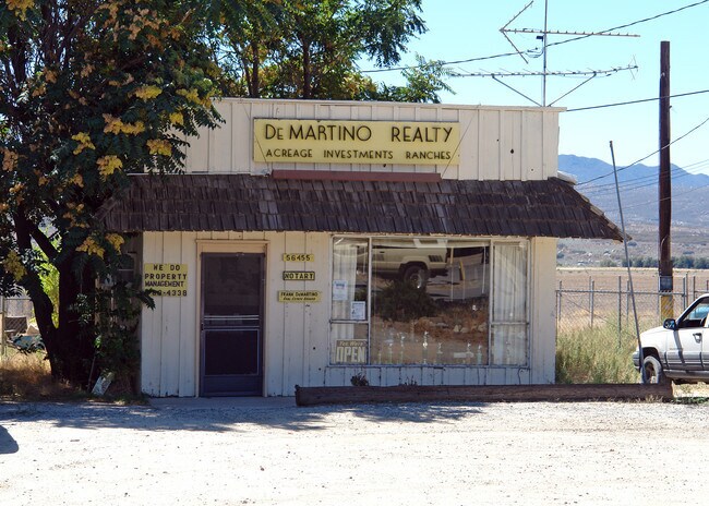
Property Record
56461 Highway 371, Riverside, CA 92506


NEARBY LISTINGS FOR SALE OR LEASE
-
-
View all Riverside listings for sale on LoopNet.com
Property Detail
56461 Highway 371
576-080-006
1.07 ACRES NET IN PAR 3 PM 148/020 PM 21954
Supermarket
Riverside
X
California
06065C2825G
3
2024
1.07 AC
2025
Riverside Outlying
031200
Inland Empire (California)
3,960 SF
Riverside-San Bernardino-Ontario, CA
DEMOGRAPHICS near 56461 Highway 371
1 mile
3 mile
5 mile
2024 Total Population
134
1,372
3,394
2029 Population
132
1,353
3,368
Pop Growth 2024-2029
(1.49%)
(1.38%)
(0.77%)
Average Age
44
44
44
2024 Total Households
52
529
1,304
HH Growth 2024-2029
(3.85%)
(2.46%)
(1.69%)
Median Household Inc
$47,777
$47,724
$48,926
Avg Household Size
2.50
2.40
2.40
2024 Avg HH Vehicles
2.00
2.00
2.00
Median Home Value
$250,000
$266,853
$303,316
Median Year Built
1985
1984
1984
Nearby Places
Map Layers
Map Styles
 Street
 Aerial
Transit
 Traffic
 Biking
Places
Listings with unknown addresses are not visible on the map
- Restaurants
- Banks
- Shops
- Fitness
- Groceries
PUBLIC TRANSPORTATION
AIRPORT
Palm Springs International
Drive
Walk
Distance
Palm Springs International
62 min
41.6 mi
Nearby Properties
Address
Land Use
TOTAL SIZE
Lot Size
Zoning
Address
Land Use
TOTAL SIZE
Lot Size
Zoning
12,935 SF
3.53 AC
A1212
Address
Land Use
TOTAL SIZE
Lot Size
Zoning
9,100 SF
1.31 AC
Address
Land Use
TOTAL SIZE
Lot Size
Zoning
1,560 SF
0.83 AC
CPS
Address
Land Use
TOTAL SIZE
Lot Size
Zoning
5,570 SF
34.76 AC
M3
Address
Land Use
TOTAL SIZE
Lot Size
Zoning
5,040 SF
2.33 AC
RR
Address
Land Use
TOTAL SIZE
Lot Size
Zoning
5,040 SF
1.36 AC
RR
Address
Land Use
TOTAL SIZE
Lot Size
Zoning
5,000 SF
4.32 AC
MM
Address
Land Use
TOTAL SIZE
Lot Size
Zoning
8,692 SF
0.80 AC
CPS
Address
Land Use
TOTAL SIZE
Lot Size
Zoning
4,500 SF
0.91 AC
MM
Address
Land Use
TOTAL SIZE
Lot Size
Zoning
1,032 SF
20 AC
AL
Address
Land Use
TOTAL SIZE
Lot Size
Zoning
4,159 SF
2.58 AC
Address
Land Use
TOTAL SIZE
Lot Size
Zoning
3,840 SF
1.74 AC
C1CP
Address
Land Use
TOTAL SIZE
Lot Size
Zoning
3,200 SF
7.76 AC
MIX
Address
Land Use
TOTAL SIZE
Lot Size
Zoning
3,618 SF
4.83 AC
RR212
Address
Land Use
TOTAL SIZE
Lot Size
Zoning
4,051 SF
6.64 AC
RR212
Address
Land Use
TOTAL SIZE
Lot Size
Zoning
4,204 SF
9.69 AC
RR5
Address
Land Use
TOTAL SIZE
Lot Size
Zoning
5,117 SF
2.35 AC
RR
Address
Land Use
TOTAL SIZE
Lot Size
Zoning
1,716 SF
0.84 AC
CPS
Address
Land Use
TOTAL SIZE
Lot Size
Zoning
1,680 SF
0.35 AC
CPS
Address
Land Use
TOTAL SIZE
Lot Size
Zoning
1,550 SF
1.85 AC
RR212
Address
Land Use
TOTAL SIZE
Lot Size
Zoning
2,853 SF
10.10 AC
RR212
Address
Land Use
TOTAL SIZE
Lot Size
Zoning
4,288 SF
9.79 AC
RR
Address
Land Use
TOTAL SIZE
Lot Size
Zoning
3,200 SF
5.22 AC
RR
Address
Land Use
TOTAL SIZE
Lot Size
Zoning
2,752 SF
4.17 AC
RA5
Address
Land Use
TOTAL SIZE
Lot Size
Zoning
3,618 SF
5 AC
RR
Address
Land Use
TOTAL SIZE
Lot Size
Zoning
1,567 SF
5.25 AC
RA5
Address
Land Use
TOTAL SIZE
Lot Size
Zoning
3,272 SF
4 AC
RR
Address
Land Use
TOTAL SIZE
Lot Size
Zoning
2,068 SF
157.20 AC
RR20
Address
Land Use
TOTAL SIZE
Lot Size
Zoning
792 SF
5 AC
RR
Address
Land Use
TOTAL SIZE
Lot Size
Zoning
52.03 AC
RR
The World's #1 Commercial Real Estate Marketplace
Connect with us
© 2026 CoStar Group
The information above has been obtained from sources believed reliable. While we do not doubt its accuracy we have not verified it and make no guarantee, warranty or representation about it. It is your responsibility to independently confirm its accuracy and completeness. Any projections, opinions, assumptions, or estimates used are for example only and do not represent the current or future performance of the property. The value of this transaction to you depends on tax and other factors which should be evaluated by your tax, financial, and legal advisors. You and your advisors should conduct a careful, independent investigation of the property to determine to your satisfaction the suitability of the property for your needs.