Property Record
5645 Highway 128, Geyserville, CA 95441
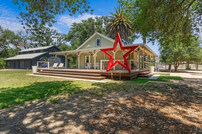
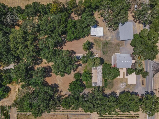
This Property Is For Sale
NEARBY LISTINGS FOR SALE OR LEASE
-
-
View all Geyserville listings for sale on LoopNet.com
Property Detail
5645 Highway 128
131-100-023
2015 FM 131-100-006 & REM 008 LLA COUNTY
Pasture
Sonoma
AE
California
06097C0365E
4.30 AC
2024
Northeast Sonoma County
2025
North Bay/Santa Rosa
154100
Santa Rosa, CA
DEMOGRAPHICS near 5645 Highway 128
1 Mile
3 Mile
5 Mile
2024 Total Population
86
1,093
14,876
2029 Population
82
1,100
15,065
Pop Growth 2024-2029
(4.65%)
+ 0.64%
+ 1.27%
Average Age
48
48
46
2024 Total Households
33
427
6,032
HH Growth 2024-2029
(6.06%)
+ 0.70%
+ 1.19%
Median Household Inc
$134,375
$132,291
$107,692
Avg Household Size
2.60
2.50
2.40
2024 Avg HH Vehicles
3.00
3.00
2.00
Median Home Value
$1,064,286
$1,082,105
$965,848
Median Year Built
1964
1977
1977
Nearby Places
Map Layers
Map Styles
 Street
 Aerial
- Restaurants
- Banks
- Shops
- Fitness
- Groceries
PUBLIC TRANSPORTATION
AIRPORT
Charles M Schulz - Sonoma County
DRIVE
WALK
Distance
Charles M Schulz - Sonoma County
28 min
17.8 mi
Freight Ports
Port of Richmond
DRIVE
WALK
Distance
Port of Richmond
92 min
70.7 mi
Nearby Properties
Address
Land Use
TOTAL SIZE
Lot Size
Zoning
Address
Land Use
TOTAL SIZE
Lot Size
Zoning
87.32 AC
Address
Land Use
TOTAL SIZE
Lot Size
Zoning
221,430 SF
0.15 AC
LIA20
Address
Land Use
TOTAL SIZE
Lot Size
Zoning
97,068 SF
115.66 AC
LIA20
Address
Land Use
TOTAL SIZE
Lot Size
Zoning
Address
Land Use
TOTAL SIZE
Lot Size
Zoning
507.59 AC
Address
Land Use
TOTAL SIZE
Lot Size
Zoning
0.15 AC
DA10
Address
Land Use
TOTAL SIZE
Lot Size
Zoning
10,570 SF
362.51 AC
Address
Land Use
TOTAL SIZE
Lot Size
Zoning
62,360 SF
45.87 AC
LIA20
Address
Land Use
TOTAL SIZE
Lot Size
Zoning
16,142 SF
18 AC
LIA20
Address
Land Use
TOTAL SIZE
Lot Size
Zoning
16.07 AC
Address
Land Use
TOTAL SIZE
Lot Size
Zoning
40,000 SF
21.85 AC
LIA20
Address
Land Use
TOTAL SIZE
Lot Size
Zoning
14,244 SF
268.03 AC
LIA20
Address
Land Use
TOTAL SIZE
Lot Size
Zoning
4,643 SF
26 AC
LIA20
Address
Land Use
TOTAL SIZE
Lot Size
Zoning
34,424 SF
101.57 AC
LIA20
Address
Land Use
TOTAL SIZE
Lot Size
Zoning
197.63 AC
Address
Land Use
TOTAL SIZE
Lot Size
Zoning
91,784 SF
200 AC
LEA240
Address
Land Use
TOTAL SIZE
Lot Size
Zoning
10,384 SF
18.15 AC
Address
Land Use
TOTAL SIZE
Lot Size
Zoning
6,128 SF
310 AC
LIA20
Address
Land Use
TOTAL SIZE
Lot Size
Zoning
7.27 AC
LIA20
Address
Land Use
TOTAL SIZE
Lot Size
Zoning
32.12 AC
Address
Land Use
TOTAL SIZE
Lot Size
Zoning
4,905 SF
3.01 AC
Address
Land Use
TOTAL SIZE
Lot Size
Zoning
6,923 SF
60.57 AC
RRD100
Address
Land Use
TOTAL SIZE
Lot Size
Zoning
5,942 SF
32.81 AC
Address
Land Use
TOTAL SIZE
Lot Size
Zoning
54.46 AC
LIA20
Address
Land Use
TOTAL SIZE
Lot Size
Zoning
6,925 SF
10.42 AC
Address
Land Use
TOTAL SIZE
Lot Size
Zoning
26.69 AC
Address
Land Use
TOTAL SIZE
Lot Size
Zoning
15,608 SF
122.59 AC
LIA20
Address
Land Use
TOTAL SIZE
Lot Size
Zoning
39,519 SF
0.16 AC
LEA240
Address
Land Use
TOTAL SIZE
Lot Size
Zoning
17,333 SF
75.55 AC
LEA240
Address
Land Use
TOTAL SIZE
Lot Size
Zoning
40.82 AC
The World's #1 Commercial Real Estate Marketplace
Connect with us
© 2026 CoStar Group
The information above has been obtained from sources believed reliable. While we do not doubt its accuracy we have not verified it and make no guarantee, warranty or representation about it. It is your responsibility to independently confirm its accuracy and completeness. Any projections, opinions, assumptions, or estimates used are for example only and do not represent the current or future performance of the property. The value of this transaction to you depends on tax and other factors which should be evaluated by your tax, financial, and legal advisors. You and your advisors should conduct a careful, independent investigation of the property to determine to your satisfaction the suitability of the property for your needs.