Property Record
565 Benfield Rd, Severna Park, MD 21146


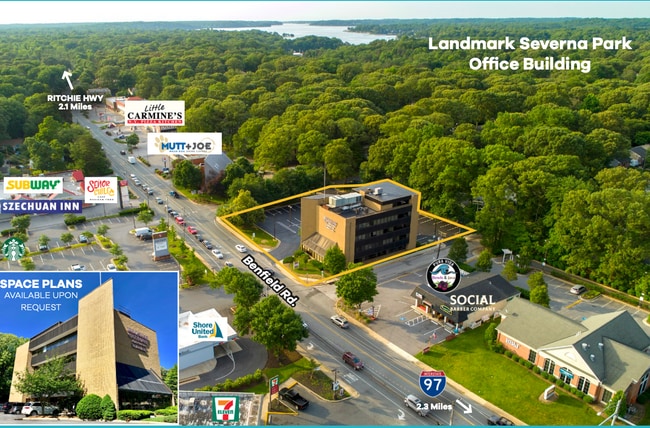
Current Lease Availabilities
NEARBY LISTINGS FOR SALE OR LEASE
Property Detail
565 Benfield Rd
Baltimore-Columbia-Towson, MD
Carrollton Manor
03-170-90035857
LTS 36TO45 PT 46 BK OR .90AC 565 BENFIELD RD CARROLLTON MANOR
Officebuilding
Anne Arundel
X
Maryland
24003C0154F
36
2024
0.90 AC
2025
Route 2 Corridor South
730702
Baltimore
25,664 SF
DEMOGRAPHICS near 565 Benfield Rd
1 Mile
3 Mile
5 Mile
2024 Total Population
9,360
46,289
136,870
2029 Population
9,614
47,451
140,099
Pop Growth 2024-2029
+ 2.71%
+ 2.51%
+ 2.36%
Average Age
41
41
40
2024 Total Households
3,122
16,190
50,217
HH Growth 2024-2029
+ 2.79%
+ 2.58%
+ 2.41%
Median Household Inc
$146,905
$149,650
$114,963
Avg Household Size
2.90
2.80
2.70
2024 Avg HH Vehicles
2.00
2.00
2.00
Median Home Value
$585,866
$613,618
$450,773
Median Year Built
1976
1979
1979
Nearby Places
Map Layers
Map Styles
 Street
 Aerial
- Restaurants
- Banks
- Shops
- Fitness
- Groceries
PUBLIC TRANSPORTATION
COMMUTER RAIL
Odenton (Penn Line - Maryland Area Regional Commuter Trains (The MARC))
DRIVE
WALK
Distance
Odenton (Penn Line - Maryland Area Regional Commuter Trains (The MARC))
17 min
8.2 mi
AIRPORT
Baltimore/Washington International Thurgood Marshall
DRIVE
WALK
Distance
Baltimore/Washington International Thurgood Marshall
21 min
12.7 mi
Ronald Reagan Washington Ntl
DRIVE
WALK
Distance
Ronald Reagan Washington Ntl
56 min
36.3 mi
Freight Ports
Port of Baltimore
DRIVE
WALK
Distance
Port of Baltimore
27 min
17.9 mi
Nearby Properties
Address
Land Use
TOTAL SIZE
Lot Size
Zoning
Address
Land Use
TOTAL SIZE
Lot Size
Zoning
285,360 SF
14.96 AC
Address
Land Use
TOTAL SIZE
Lot Size
Zoning
277,037 SF
10.45 AC
R5
Address
Land Use
TOTAL SIZE
Lot Size
Zoning
182,697 SF
20.82 AC
C3
Address
Land Use
TOTAL SIZE
Lot Size
Zoning
235,713 SF
19.64 AC
C3
Address
Land Use
TOTAL SIZE
Lot Size
Zoning
123,376 SF
25.42 AC
C3
Address
Land Use
TOTAL SIZE
Lot Size
Zoning
108,064 SF
9.24 AC
R10
Address
Land Use
TOTAL SIZE
Lot Size
Zoning
106,160 SF
5.11 AC
R-2
Address
Land Use
TOTAL SIZE
Lot Size
Zoning
106,760 SF
5.09 AC
C4
Address
Land Use
TOTAL SIZE
Lot Size
Zoning
139,230 SF
39.22 AC
R2
Address
Land Use
TOTAL SIZE
Lot Size
Zoning
154,056 SF
19.89 AC
R2
Address
Land Use
TOTAL SIZE
Lot Size
Zoning
209,143 SF
19.29 AC
C3
Address
Land Use
TOTAL SIZE
Lot Size
Zoning
79,311 SF
3.90 AC
C2
Address
Land Use
TOTAL SIZE
Lot Size
Zoning
272,245 SF
40.30 AC
R5
Address
Land Use
TOTAL SIZE
Lot Size
Zoning
121,846 SF
8.10 AC
C4
Address
Land Use
TOTAL SIZE
Lot Size
Zoning
128,466 SF
18.70 AC
W1
Address
Land Use
TOTAL SIZE
Lot Size
Zoning
82,712 SF
32.59 AC
R5
Address
Land Use
TOTAL SIZE
Lot Size
Zoning
114,602 SF
10.26 AC
C3
Address
Land Use
TOTAL SIZE
Lot Size
Zoning
98,109 SF
5.33 AC
C2
Address
Land Use
TOTAL SIZE
Lot Size
Zoning
75,634 SF
17.37 AC
R5
Address
Land Use
TOTAL SIZE
Lot Size
Zoning
46,896 SF
3.29 AC
C1B
Address
Land Use
TOTAL SIZE
Lot Size
Zoning
48,036 SF
15.99 AC
RLD
Address
Land Use
TOTAL SIZE
Lot Size
Zoning
87,878 SF
3.91 AC
C4
Address
Land Use
TOTAL SIZE
Lot Size
Zoning
70,452 SF
15.69 AC
R5
Address
Land Use
TOTAL SIZE
Lot Size
Zoning
49,713 SF
5 AC
R1
Address
Land Use
TOTAL SIZE
Lot Size
Zoning
77,528 SF
4.28 AC
R2
Address
Land Use
TOTAL SIZE
Lot Size
Zoning
55,291 SF
20.77 AC
R2
Address
Land Use
TOTAL SIZE
Lot Size
Zoning
75,540 SF
10.10 AC
W1
Address
Land Use
TOTAL SIZE
Lot Size
Zoning
53,742 SF
11.50 AC
R2
Address
Land Use
TOTAL SIZE
Lot Size
Zoning
36,720 SF
3.74 AC
R2
Address
Land Use
TOTAL SIZE
Lot Size
Zoning
123,000 SF
9.92 AC
W1
The World's #1 Commercial Real Estate Marketplace
Connect with us
© 2025 CoStar Group
The information above has been obtained from sources believed reliable. While we do not doubt its accuracy we have not verified it and make no guarantee, warranty or representation about it. It is your responsibility to independently confirm its accuracy and completeness. Any projections, opinions, assumptions, or estimates used are for example only and do not represent the current or future performance of the property. The value of this transaction to you depends on tax and other factors which should be evaluated by your tax, financial, and legal advisors. You and your advisors should conduct a careful, independent investigation of the property to determine to your satisfaction the suitability of the property for your needs.