Property Record
565 Edwards Rd, Inman, SC 29349
Property Detail
565 Edwards Rd
2-27-00-005.01
P/O TRACT D ROGER MILLIKEN SURVE Y PB 89-494-A-B DB 79W-444
Taxexempt
Spartanburg
B and X Area of moderate flood hazard, usually the area between the limits of the 100-year and 500-year floods.
South Carolina
2024
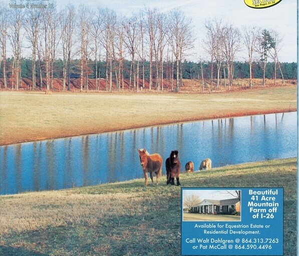
36.01 AC
2025
Upper Spartanburg County
022804
Greenville/Spartanburg
3,340 SF
Spartanburg, SC
NEARBY LISTINGS FOR SALE OR LEASE
-
-
View all Inman listings for sale on LoopNet.com
DEMOGRAPHICS near 565 Edwards Rd
1 mile
3 mile
5 mile
2025 Total Population
845
11,525
37,002
2030 Population
941
12,907
41,543
Pop Growth 2025-2030
+ 11.36%
+ 11.99%
+ 12.27%
Average Age
43
41
41
2025 Total Households
320
4,322
13,904
HH Growth 2025-2030
+ 11.56%
+ 12.12%
+ 12.39%
Median Household Inc
$100,625
$82,024
$72,100
Avg Household Size
2.60
2.60
2.60
2025 Avg HH Vehicles
3.00
2.00
2.00
Median Home Value
$282,231
$282,132
$270,325
Median Year Built
1991
1995
1995
Nearby Places
Map Layers
Map Styles
 Street
 Aerial
Transit
 Traffic
 Biking
Places
Listings with unknown addresses are not visible on the map
- Restaurants
- Banks
- Shops
- Fitness
- Groceries
PUBLIC TRANSPORTATION
AIRPORT
Greenville Spartanburg International
Drive
Walk
Distance
Greenville Spartanburg International
36 min
24.2 mi
Freight Ports
North Charleston Terminal
Drive
Walk
Distance
North Charleston Terminal
231 min
205.0 mi
Nearby Properties
Address
Land Use
TOTAL SIZE
Lot Size
Zoning
Address
Land Use
TOTAL SIZE
Lot Size
Zoning
6,524 SF
0.98 AC
Address
Land Use
TOTAL SIZE
Lot Size
Zoning
6,945 SF
0.65 AC
Address
Land Use
TOTAL SIZE
Lot Size
Zoning
15,130 SF
7.17 AC
Address
Land Use
TOTAL SIZE
Lot Size
Zoning
3,158 SF
0.69 AC
Address
Land Use
TOTAL SIZE
Lot Size
Zoning
3,620 SF
0.67 AC
Address
Land Use
TOTAL SIZE
Lot Size
Zoning
4,260 SF
0.66 AC
Address
Land Use
TOTAL SIZE
Lot Size
Zoning
3,166 SF
Address
Land Use
TOTAL SIZE
Lot Size
Zoning
3,717 SF
0.55 AC
Address
Land Use
TOTAL SIZE
Lot Size
Zoning
3,495 SF
0.74 AC
Address
Land Use
TOTAL SIZE
Lot Size
Zoning
4,474 SF
5.03 AC
Address
Land Use
TOTAL SIZE
Lot Size
Zoning
3,237 SF
7.33 AC
Address
Land Use
TOTAL SIZE
Lot Size
Zoning
2,977 SF
0.52 AC
Address
Land Use
TOTAL SIZE
Lot Size
Zoning
5,733 SF
0.29 AC
Address
Land Use
TOTAL SIZE
Lot Size
Zoning
2,616 SF
0.69 AC
Address
Land Use
TOTAL SIZE
Lot Size
Zoning
3,480 SF
0.30 AC
Address
Land Use
TOTAL SIZE
Lot Size
Zoning
3,585 SF
0.53 AC
Address
Land Use
TOTAL SIZE
Lot Size
Zoning
1,651 SF
0.15 AC
Address
Land Use
TOTAL SIZE
Lot Size
Zoning
41.18 AC
Address
Land Use
TOTAL SIZE
Lot Size
Zoning
3,164 SF
0.28 AC
Address
Land Use
TOTAL SIZE
Lot Size
Zoning
3,611 SF
0.57 AC
Address
Land Use
TOTAL SIZE
Lot Size
Zoning
2,168 SF
0.12 AC
Address
Land Use
TOTAL SIZE
Lot Size
Zoning
2,565 SF
0.59 AC
Address
Land Use
TOTAL SIZE
Lot Size
Zoning
1,877 SF
0.98 AC
Address
Land Use
TOTAL SIZE
Lot Size
Zoning
2,596 SF
4.06 AC
Address
Land Use
TOTAL SIZE
Lot Size
Zoning
3,150 SF
0.62 AC
Address
Land Use
TOTAL SIZE
Lot Size
Zoning
3,050 SF
1.45 AC
Address
Land Use
TOTAL SIZE
Lot Size
Zoning
2,042 SF
0.57 AC
Address
Land Use
TOTAL SIZE
Lot Size
Zoning
573,264 SF
8.77 AC
Address
Land Use
TOTAL SIZE
Lot Size
Zoning
3,405 SF
2.90 AC
The World's #1 Commercial Real Estate Marketplace
Connect with us
© 2026 CoStar Group
The information above has been obtained from sources believed reliable. While we do not doubt its accuracy we have not verified it and make no guarantee, warranty or representation about it. It is your responsibility to independently confirm its accuracy and completeness. Any projections, opinions, assumptions, or estimates used are for example only and do not represent the current or future performance of the property. The value of this transaction to you depends on tax and other factors which should be evaluated by your tax, financial, and legal advisors. You and your advisors should conduct a careful, independent investigation of the property to determine to your satisfaction the suitability of the property for your needs.