Property Record
565 W Madison St, Waterloo, WI 53594
NEARBY LISTINGS FOR SALE OR LEASE
-
-
View all Waterloo listings for sale on LoopNet.com
Property Detail
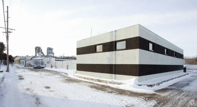
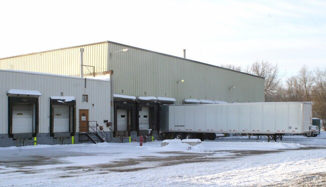
565 W Madison St
Watertown-Fort Atkinson, WI
Bradford Hill Add
290-0813-0643-049
LOT 1, CSM 1102-3-651, DOC 749305. ALSO LOT 38, INDIAN HILLS SOUTH. ALSO OUTLOT 91, ASSESSOR'S PLAT. ALSO COM SW/C LOT 9, BLK 6, 1ST ADD TO BRADFORD HILL ADD, S02DG 01'E 35.02FT, S01DG09'W 354. 93FT TO POB, S88DG51'E 331. 03FT, S05DG27'E 244.10FT, S
Commercialnec
Jefferson
AE
Wisconsin
55055C0036F
9
2024
3.10 AC
2024
Jefferson North
100400
Milwaukee/Madison
DEMOGRAPHICS near 565 W Madison St
1 Mile
3 Mile
5 Mile
2024 Total Population
3,503
5,146
9,600
2029 Population
3,545
5,202
9,779
Pop Growth 2024-2029
+ 1.20%
+ 1.09%
+ 1.86%
Average Age
41
41
41
2024 Total Households
1,414
2,056
3,768
HH Growth 2024-2029
+ 1.49%
+ 1.22%
+ 1.94%
Median Household Inc
$64,239
$67,757
$68,276
Avg Household Size
2.50
2.50
2.50
2024 Avg HH Vehicles
2.00
2.00
2.00
Median Home Value
$223,677
$236,856
$250,472
Median Year Built
1970
1971
1976
Nearby Places
Map Layers
Map Styles
 Street
 Aerial
- Restaurants
- Banks
- Shops
- Fitness
- Groceries
PUBLIC TRANSPORTATION
AIRPORT
Dane County Regional/Truax Field
DRIVE
WALK
Distance
Dane County Regional/Truax Field
34 min
24.1 mi
Freight Ports
Port Milwaukee
DRIVE
WALK
Distance
Port Milwaukee
81 min
63.8 mi
Nearby Properties
Address
Land Use
TOTAL SIZE
Lot Size
Zoning
Address
Land Use
TOTAL SIZE
Lot Size
Zoning
27.39 AC
Address
Land Use
TOTAL SIZE
Lot Size
Zoning
3.72 AC
Address
Land Use
TOTAL SIZE
Lot Size
Zoning
18.06 AC
Address
Land Use
TOTAL SIZE
Lot Size
Zoning
10.27 AC
Address
Land Use
TOTAL SIZE
Lot Size
Zoning
12.43 AC
Address
Land Use
TOTAL SIZE
Lot Size
Zoning
7.29 AC
Address
Land Use
TOTAL SIZE
Lot Size
Zoning
38.75 AC
Address
Land Use
TOTAL SIZE
Lot Size
Zoning
15.15 AC
Address
Land Use
TOTAL SIZE
Lot Size
Zoning
3.70 AC
Address
Land Use
TOTAL SIZE
Lot Size
Zoning
2.94 AC
Address
Land Use
TOTAL SIZE
Lot Size
Zoning
1.57 AC
Address
Land Use
TOTAL SIZE
Lot Size
Zoning
1.83 AC
Address
Land Use
TOTAL SIZE
Lot Size
Zoning
85.90 AC
RE-1
Address
Land Use
TOTAL SIZE
Lot Size
Zoning
2.09 AC
Address
Land Use
TOTAL SIZE
Lot Size
Zoning
1.32 AC
Address
Land Use
TOTAL SIZE
Lot Size
Zoning
1.22 AC
Address
Land Use
TOTAL SIZE
Lot Size
Zoning
0.69 AC
Address
Land Use
TOTAL SIZE
Lot Size
Zoning
2.17 AC
Address
Land Use
TOTAL SIZE
Lot Size
Zoning
4.63 AC
Address
Land Use
TOTAL SIZE
Lot Size
Zoning
17.28 AC
RH-4
Address
Land Use
TOTAL SIZE
Lot Size
Zoning
39.10 AC
A-1 EX
Address
Land Use
TOTAL SIZE
Lot Size
Zoning
1.38 AC
Address
Land Use
TOTAL SIZE
Lot Size
Zoning
0.43 AC
Address
Land Use
TOTAL SIZE
Lot Size
Zoning
0.43 AC
Address
Land Use
TOTAL SIZE
Lot Size
Zoning
0.43 AC
Address
Land Use
TOTAL SIZE
Lot Size
Zoning
0.43 AC
Address
Land Use
TOTAL SIZE
Lot Size
Zoning
0.43 AC
Address
Land Use
TOTAL SIZE
Lot Size
Zoning
0.42 AC
The World's #1 Commercial Real Estate Marketplace
Connect with us
© 2025 CoStar Group
The information above has been obtained from sources believed reliable. While we do not doubt its accuracy we have not verified it and make no guarantee, warranty or representation about it. It is your responsibility to independently confirm its accuracy and completeness. Any projections, opinions, assumptions, or estimates used are for example only and do not represent the current or future performance of the property. The value of this transaction to you depends on tax and other factors which should be evaluated by your tax, financial, and legal advisors. You and your advisors should conduct a careful, independent investigation of the property to determine to your satisfaction the suitability of the property for your needs.