Property Record
565 W West Branch Rd, Prudenville, MI 48651
NEARBY LISTINGS FOR SALE OR LEASE
-
-
View all Prudenville listings for sale on LoopNet.com
Property Detail
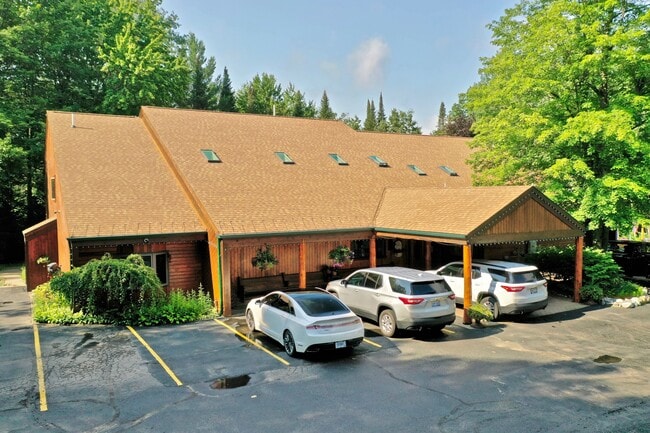
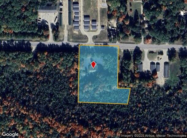
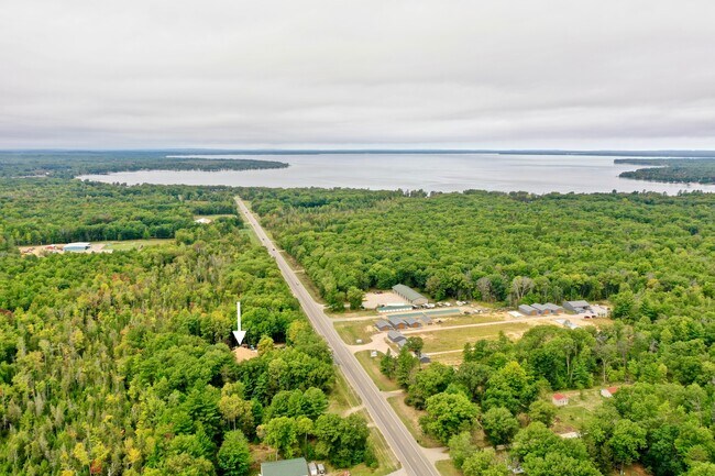
565 W West Branch Rd
Commercialnec
L-941 P-681 223 COM AT N 1/4 COR SEC 13 TH S88DEG01'20"E ALG SEC LINE 82.50FT TH S01DEG59'15"W 382.85FT TH S88DEG01'20"E
X
Roscommon
26143C0315A
Michigan
2025
4.62 AC
2025
Michigan North Central Area
971100
Other Market Areas
7,500 SF
003-013-002-0630
DEMOGRAPHICS near 565 W West Branch Rd
1 Mile
3 Mile
5 Mile
2024 Total Population
767
3,659
6,152
2029 Population
770
3,722
6,289
Pop Growth 2024-2029
+ 0.39%
+ 1.72%
+ 2.23%
Average Age
48
50
50
2024 Total Households
365
1,757
3,013
HH Growth 2024-2029
0.00%
+ 1.42%
+ 1.96%
Median Household Inc
$37,916
$45,664
$45,042
Avg Household Size
2.10
2.00
2.00
2024 Avg HH Vehicles
2.00
2.00
2.00
Median Home Value
$151,098
$162,499
$154,114
Median Year Built
1976
1975
1975
Nearby Places
Map Layers
Map Styles
 Street
 Aerial
- Restaurants
- Banks
- Shops
- Fitness
- Groceries
SALE & LEASE HISTORY
LISTING DATE
SALE/LEASE

Mar 04, 2021
For Sale
Nearby Properties
Address
Land Use
TOTAL SIZE
Lot Size
Zoning
Address
Land Use
TOTAL SIZE
Lot Size
Zoning
202,091 SF
38.37 AC
Address
Land Use
TOTAL SIZE
Lot Size
Zoning
34,076 SF
5.67 AC
Address
Land Use
TOTAL SIZE
Lot Size
Zoning
8,890 SF
115 AC
Address
Land Use
TOTAL SIZE
Lot Size
Zoning
14,722 SF
2.13 AC
Address
Land Use
TOTAL SIZE
Lot Size
Zoning
18,944 SF
4.84 AC
Address
Land Use
TOTAL SIZE
Lot Size
Zoning
9,710 SF
2.81 AC
Address
Land Use
TOTAL SIZE
Lot Size
Zoning
26,880 SF
3.36 AC
Address
Land Use
TOTAL SIZE
Lot Size
Zoning
12,482 SF
1.14 AC
Address
Land Use
TOTAL SIZE
Lot Size
Zoning
Address
Land Use
TOTAL SIZE
Lot Size
Zoning
4,675 SF
1.05 AC
Address
Land Use
TOTAL SIZE
Lot Size
Zoning
13,104 SF
1.99 AC
Address
Land Use
TOTAL SIZE
Lot Size
Zoning
4,691 SF
0.53 AC
Address
Land Use
TOTAL SIZE
Lot Size
Zoning
6,048 SF
1.46 AC
Address
Land Use
TOTAL SIZE
Lot Size
Zoning
6,400 SF
80 AC
Address
Land Use
TOTAL SIZE
Lot Size
Zoning
23,450 SF
2.45 AC
Address
Land Use
TOTAL SIZE
Lot Size
Zoning
6,791 SF
1.65 AC
Address
Land Use
TOTAL SIZE
Lot Size
Zoning
6,322 SF
0.52 AC
Address
Land Use
TOTAL SIZE
Lot Size
Zoning
25,099 SF
6.79 AC
Address
Land Use
TOTAL SIZE
Lot Size
Zoning
3,168 SF
0.55 AC
Address
Land Use
TOTAL SIZE
Lot Size
Zoning
15,360 SF
1.43 AC
Address
Land Use
TOTAL SIZE
Lot Size
Zoning
2,310 SF
1.11 AC
Address
Land Use
TOTAL SIZE
Lot Size
Zoning
11,025 SF
2.05 AC
Address
Land Use
TOTAL SIZE
Lot Size
Zoning
5,884 SF
0.90 AC
Address
Land Use
TOTAL SIZE
Lot Size
Zoning
1,110 SF
1.55 AC
Address
Land Use
TOTAL SIZE
Lot Size
Zoning
7.44 AC
Address
Land Use
TOTAL SIZE
Lot Size
Zoning
10,000 SF
0.86 AC
Address
Land Use
TOTAL SIZE
Lot Size
Zoning
3,840 SF
1.44 AC
Address
Land Use
TOTAL SIZE
Lot Size
Zoning
5,976 SF
0.60 AC
Address
Land Use
TOTAL SIZE
Lot Size
Zoning
27,600 SF
2.88 AC
The World's #1 Commercial Real Estate Marketplace
Connect with us
© 2026 CoStar Group
The information above has been obtained from sources believed reliable. While we do not doubt its accuracy we have not verified it and make no guarantee, warranty or representation about it. It is your responsibility to independently confirm its accuracy and completeness. Any projections, opinions, assumptions, or estimates used are for example only and do not represent the current or future performance of the property. The value of this transaction to you depends on tax and other factors which should be evaluated by your tax, financial, and legal advisors. You and your advisors should conduct a careful, independent investigation of the property to determine to your satisfaction the suitability of the property for your needs.