Property Record
565 Yoder Rd, Harleysville, PA 19438
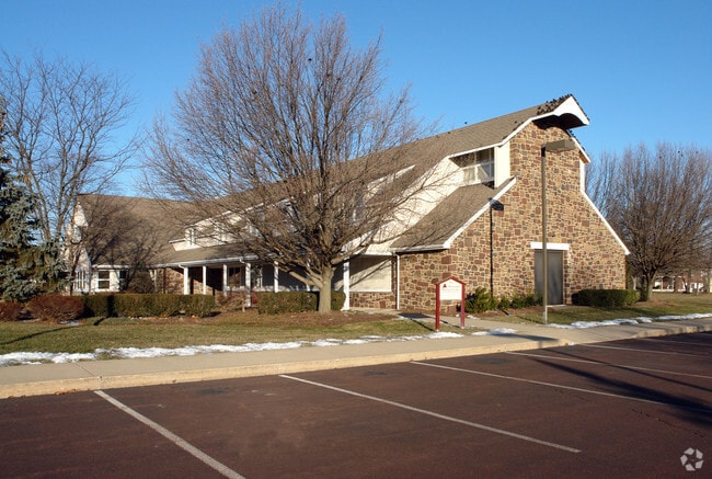


Property Detail
565 Yoder Rd
34-00-04993-103
MENNONITE MUSEUM & CENTER
Charitableorganization
Montgomery
R130
Pennsylvania
B and X Area of moderate flood hazard, usually the area between the limits of the 100-year and 500-year floods.
35
0
3 AC
2026
West Montgomery County
207101
Philadelphia
11,929 SF
Philadelphia-Camden-Wilmington, PA-NJ-DE-MD
NEARBY LISTINGS FOR SALE OR LEASE
-
-
View all Harleysville listings for sale on LoopNet.com
DEMOGRAPHICS near 565 Yoder Rd
1 mile
3 mile
5 mile
2025 Total Population
5,905
27,558
95,154
2030 Population
6,049
28,207
97,562
Pop Growth 2025-2030
+ 2.44%
+ 2.36%
+ 2.53%
Average Age
45
44
43
2025 Total Households
2,107
10,106
35,582
HH Growth 2025-2030
+ 2.52%
+ 2.40%
+ 2.43%
Median Household Inc
$121,857
$117,395
$105,989
Avg Household Size
2.50
2.60
2.50
2025 Avg HH Vehicles
2.00
2.00
2.00
Median Home Value
$470,705
$474,104
$439,614
Median Year Built
1987
1985
1983
Nearby Places
Map Layers
Map Styles
 Street
 Aerial
Layers
 Traffic
 Biking
Places
Listings with unknown addresses are not visible on the map
- Restaurants
- Banks
- Shops
- Fitness
- Groceries
PUBLIC TRANSPORTATION
COMMUTER RAIL
Lansdale (R5 - Southeastern Pennsylvania Transportation Authority Regional Rail (SEPTA Regional Rail))
Drive
Walk
Distance
Lansdale (R5 - Southeastern Pennsylvania Transportation Authority Regional Rail (SEPTA Regional Rail))
16 min
6.9 mi
9Th Street Lansdale (Lansdale/Doylestown Line - SEPTA)
Drive
Walk
Distance
9Th Street Lansdale (Lansdale/Doylestown Line - SEPTA)
18 min
7.5 mi
AIRPORT
Lehigh Valley International
Drive
Walk
Distance
Lehigh Valley International
54 min
36.3 mi
Philadelphia International
Drive
Walk
Distance
Philadelphia International
58 min
40.7 mi
Trenton Mercer
Drive
Walk
Distance
Trenton Mercer
64 min
48.9 mi
Freight Ports
Port of Philadelphia
Drive
Walk
Distance
Port of Philadelphia
50 min
30.4 mi
Nearby Properties
Address
Land Use
TOTAL SIZE
Lot Size
Zoning
Address
Land Use
TOTAL SIZE
Lot Size
Zoning
437,908 SF
104.29 AC
INST
Address
Land Use
TOTAL SIZE
Lot Size
Zoning
677,546 SF
92.50 AC
INST
Address
Land Use
TOTAL SIZE
Lot Size
Zoning
139,733 SF
46.65 AC
R130
Address
Land Use
TOTAL SIZE
Lot Size
Zoning
349,078 SF
18.46 AC
INST
Address
Land Use
TOTAL SIZE
Lot Size
Zoning
211,561 SF
38.80 AC
LI
Address
Land Use
TOTAL SIZE
Lot Size
Zoning
152,085 SF
38.16 AC
INST
Address
Land Use
TOTAL SIZE
Lot Size
Zoning
149,259 SF
4.30 AC
R3
Address
Land Use
TOTAL SIZE
Lot Size
Zoning
156,694 SF
18.82 AC
C
Address
Land Use
TOTAL SIZE
Lot Size
Zoning
147,113 SF
31.41 AC
R1
Address
Land Use
TOTAL SIZE
Lot Size
Zoning
136,281 SF
4.05 AC
R3
Address
Land Use
TOTAL SIZE
Lot Size
Zoning
52,348 SF
21.30 AC
R5
Address
Land Use
TOTAL SIZE
Lot Size
Zoning
84,887 SF
38.07 AC
INST
Address
Land Use
TOTAL SIZE
Lot Size
Zoning
197,233 SF
15.66 AC
LI
Address
Land Use
TOTAL SIZE
Lot Size
Zoning
90,217 SF
19 AC
R1
Address
Land Use
TOTAL SIZE
Lot Size
Zoning
246,631 SF
48.78 AC
AO
Address
Land Use
TOTAL SIZE
Lot Size
Zoning
112,282 SF
11.23 AC
R5
Address
Land Use
TOTAL SIZE
Lot Size
Zoning
77,878 SF
17.60 AC
INST
Address
Land Use
TOTAL SIZE
Lot Size
Zoning
93,049 SF
20.88 AC
CB
Address
Land Use
TOTAL SIZE
Lot Size
Zoning
60,519 SF
20.68 AC
R1
Address
Land Use
TOTAL SIZE
Lot Size
Zoning
266,880 SF
26.03 AC
LI
Address
Land Use
TOTAL SIZE
Lot Size
Zoning
29,014 SF
13.41 AC
R5
Address
Land Use
TOTAL SIZE
Lot Size
Zoning
207,616 SF
28.68 AC
LI
Address
Land Use
TOTAL SIZE
Lot Size
Zoning
176,700 SF
16.03 AC
LI
Address
Land Use
TOTAL SIZE
Lot Size
Zoning
96,305 SF
3.02 AC
Address
Land Use
TOTAL SIZE
Lot Size
Zoning
66,456 SF
2.43 AC
MU
Address
Land Use
TOTAL SIZE
Lot Size
Zoning
95,494 SF
13.67 AC
C
Address
Land Use
TOTAL SIZE
Lot Size
Zoning
143,800 SF
10.25 AC
C
Address
Land Use
TOTAL SIZE
Lot Size
Zoning
90,053 SF
24.28 AC
LI
Address
Land Use
TOTAL SIZE
Lot Size
Zoning
113,781 SF
8.62 AC
LI
Address
Land Use
TOTAL SIZE
Lot Size
Zoning
54,212 SF
18.38 AC
RR
The World's #1 Commercial Real Estate Marketplace
Connect with us
© 2026 CoStar Group
The information above has been obtained from sources believed reliable. While we do not doubt its accuracy we have not verified it and make no guarantee, warranty or representation about it. It is your responsibility to independently confirm its accuracy and completeness. Any projections, opinions, assumptions, or estimates used are for example only and do not represent the current or future performance of the property. The value of this transaction to you depends on tax and other factors which should be evaluated by your tax, financial, and legal advisors. You and your advisors should conduct a careful, independent investigation of the property to determine to your satisfaction the suitability of the property for your needs.