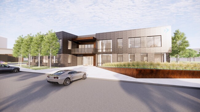
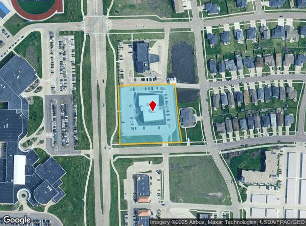
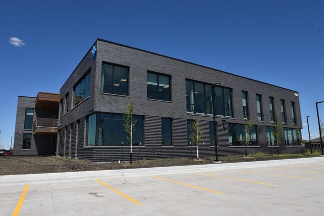
Property Record
5651 38Th Ave S, Fargo, ND 58104
Current Lease Availabilities
NEARBY LISTINGS FOR SALE OR LEASE
Property Detail
5651 38Th Ave S
Other Market Areas
Burritt-Kennedy Addition To The City Of
Fargo, ND-MN
LOT: 2 BLOCK: 1 ADDITION: BANK FORWARD ADDITION ADDITIONAL: BANK FORWARD ADDITION LT 2 BLK 1 **5-31-22 REPLAT FRM
01-8812-00200-000
Cass
Officebuilding
North Dakota
2024
2
2024
Fargo
040501
DEMOGRAPHICS near 5651 38Th Ave S
1 Mile
3 Mile
5 Mile
2024 Total Population
14,428
79,113
141,793
2029 Population
15,533
84,793
151,568
Pop Growth 2024-2029
+ 7.66%
+ 7.18%
+ 6.89%
Average Age
33
34
36
2024 Total Households
5,555
33,001
60,455
HH Growth 2024-2029
+ 8.03%
+ 7.46%
+ 7.06%
Median Household Inc
$96,023
$85,708
$78,360
Avg Household Size
2.50
2.30
2.30
2024 Avg HH Vehicles
2.00
2.00
2.00
Median Home Value
$448,655
$369,032
$311,506
Median Year Built
2010
2008
2001
Nearby Places
- Restaurants
- Banks
- Shops
- Fitness
- Groceries
PUBLIC TRANSPORTATION
COMMUTER RAIL
Fargo Amtrak Station (Empire Builder - Amtrak)
DRIVE
WALK
Distance
Fargo Amtrak Station (Empire Builder - Amtrak)
16 min
8.7 mi
AIRPORT
Hector International
DRIVE
WALK
Distance
Hector International
21 min
11.7 mi
Freight Ports
Port Milwaukee
DRIVE
WALK
Distance
Port Milwaukee
634 min
576.9 mi
Nearby Properties
Address
Land Use
TOTAL SIZE
Lot Size
Zoning
Address
Land Use
TOTAL SIZE
Lot Size
Zoning
55.68 AC
Address
Land Use
TOTAL SIZE
Lot Size
Zoning
Address
Land Use
TOTAL SIZE
Lot Size
Zoning
418,024 SF
10.88 AC
Address
Land Use
TOTAL SIZE
Lot Size
Zoning
230,272 SF
21.77 AC
GC
Address
Land Use
TOTAL SIZE
Lot Size
Zoning
Address
Land Use
TOTAL SIZE
Lot Size
Zoning
Address
Land Use
TOTAL SIZE
Lot Size
Zoning
7.66 AC
Address
Land Use
TOTAL SIZE
Lot Size
Zoning
Address
Land Use
TOTAL SIZE
Lot Size
Zoning
Address
Land Use
TOTAL SIZE
Lot Size
Zoning
163,195 SF
11.95 AC
GC
Address
Land Use
TOTAL SIZE
Lot Size
Zoning
Address
Land Use
TOTAL SIZE
Lot Size
Zoning
131,309 SF
6.62 AC
GC
Address
Land Use
TOTAL SIZE
Lot Size
Zoning
64,653 SF
2.20 AC
MR3
Address
Land Use
TOTAL SIZE
Lot Size
Zoning
34,100 SF
1.46 AC
MR3
Address
Land Use
TOTAL SIZE
Lot Size
Zoning
Address
Land Use
TOTAL SIZE
Lot Size
Zoning
9,279 SF
8.33 AC
MR1
Address
Land Use
TOTAL SIZE
Lot Size
Zoning
48,300 SF
2.33 AC
MR3
Address
Land Use
TOTAL SIZE
Lot Size
Zoning
30,240 SF
1.54 AC
MR2
Address
Land Use
TOTAL SIZE
Lot Size
Zoning
217,776 SF
31.82 AC
GC
Address
Land Use
TOTAL SIZE
Lot Size
Zoning
Address
Land Use
TOTAL SIZE
Lot Size
Zoning
73,907 SF
3.41 AC
MR3
Address
Land Use
TOTAL SIZE
Lot Size
Zoning
152,509 SF
18.14 AC
Address
Land Use
TOTAL SIZE
Lot Size
Zoning
146,131 SF
15.67 AC
GO
Address
Land Use
TOTAL SIZE
Lot Size
Zoning
46,271 SF
2.06 AC
MR3
Address
Land Use
TOTAL SIZE
Lot Size
Zoning
152,918 SF
5.38 AC
Address
Land Use
TOTAL SIZE
Lot Size
Zoning
122,201 SF
8.92 AC
GO
Address
Land Use
TOTAL SIZE
Lot Size
Zoning
191,151 SF
22.98 AC
LC
Address
Land Use
TOTAL SIZE
Lot Size
Zoning
54,927 SF
8.45 AC
Address
Land Use
TOTAL SIZE
Lot Size
Zoning
123,777 SF
1.90 AC
Address
Land Use
TOTAL SIZE
Lot Size
Zoning
387,326 SF
16.51 AC
GC
The World's #1 Commercial Real Estate Marketplace
Connect with us
© 2025 CoStar Group
The information above has been obtained from sources believed reliable. While we do not doubt its accuracy we have not verified it and make no guarantee, warranty or representation about it. It is your responsibility to independently confirm its accuracy and completeness. Any projections, opinions, assumptions, or estimates used are for example only and do not represent the current or future performance of the property. The value of this transaction to you depends on tax and other factors which should be evaluated by your tax, financial, and legal advisors. You and your advisors should conduct a careful, independent investigation of the property to determine to your satisfaction the suitability of the property for your needs.