Property Record
5655 Bryant St, Pittsburgh, PA 15206


Property Detail
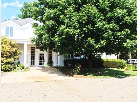
5655 Bryant St
Pittsburgh, PA
IRREG LOT 91.33X145.15X151.34 (.408 A LD) BRYANT ST COR MELLON ST 1 & 2 STY BRK OFFICE BLDG (NUIN CTR) #5655
0082-L-00264-0000-00
Allegheny
Medicalbuilding
Pennsylvania
B and X Area of moderate flood hazard, usually the area between the limits of the 100-year and 500-year floods.
264
2024
0.41 AC
2025
East End
110200
Pittsburgh
NEARBY LISTINGS FOR SALE OR LEASE
DEMOGRAPHICS near 5655 Bryant St
1 mile
3 mile
5 mile
2025 Total Population
18,694
143,747
314,305
2030 Population
18,605
143,353
313,529
Pop Growth 2025-2030
(0.48%)
(0.27%)
(0.25%)
Average Age
41
39
40
2025 Total Households
8,734
66,471
145,861
HH Growth 2025-2030
(0.53%)
(0.45%)
(0.33%)
Median Household Inc
$76,936
$67,520
$66,679
Avg Household Size
2.00
1.90
2.00
2025 Avg HH Vehicles
1.00
1.00
1.00
Median Home Value
$309,248
$300,519
$255,634
Median Year Built
1947
1949
1951
Nearby Places
Map Layers
Map Styles
 Street
 Aerial
Layers
 Traffic
 Biking
Places
Listings with unknown addresses are not visible on the map
- Restaurants
- Banks
- Shops
- Fitness
- Groceries
PUBLIC TRANSPORTATION
COMMUTER RAIL
Drive
Walk
Distance
12 min
5.7 mi
AIRPORT
Pittsburgh International
Drive
Walk
Distance
Pittsburgh International
37 min
23.5 mi
Arnold Palmer Regional
Drive
Walk
Distance
Arnold Palmer Regional
67 min
41.7 mi
SALE & LEASE HISTORY
LISTING DATE
SALE/LEASE

Apr 27, 2018
For Lease
Nearby Properties
Address
Land Use
TOTAL SIZE
Lot Size
Zoning
Address
Land Use
TOTAL SIZE
Lot Size
Zoning
Address
Land Use
TOTAL SIZE
Lot Size
Zoning
6.99 AC
Address
Land Use
TOTAL SIZE
Lot Size
Zoning
31.36 AC
Address
Land Use
TOTAL SIZE
Lot Size
Zoning
13.85 AC
Address
Land Use
TOTAL SIZE
Lot Size
Zoning
10.22 AC
Address
Land Use
TOTAL SIZE
Lot Size
Zoning
5.77 AC
Address
Land Use
TOTAL SIZE
Lot Size
Zoning
19.39 AC
Address
Land Use
TOTAL SIZE
Lot Size
Zoning
12.80 AC
Address
Land Use
TOTAL SIZE
Lot Size
Zoning
8.97 AC
Address
Land Use
TOTAL SIZE
Lot Size
Zoning
363.56 AC
Address
Land Use
TOTAL SIZE
Lot Size
Zoning
2.67 AC
Address
Land Use
TOTAL SIZE
Lot Size
Zoning
48.57 AC
Address
Land Use
TOTAL SIZE
Lot Size
Zoning
17.75 AC
Address
Land Use
TOTAL SIZE
Lot Size
Zoning
Address
Land Use
TOTAL SIZE
Lot Size
Zoning
7.89 AC
Address
Land Use
TOTAL SIZE
Lot Size
Zoning
160.63 AC
Address
Land Use
TOTAL SIZE
Lot Size
Zoning
4.10 AC
Address
Land Use
TOTAL SIZE
Lot Size
Zoning
1.36 AC
Address
Land Use
TOTAL SIZE
Lot Size
Zoning
1.22 AC
Address
Land Use
TOTAL SIZE
Lot Size
Zoning
1.54 AC
Address
Land Use
TOTAL SIZE
Lot Size
Zoning
3.13 AC
Address
Land Use
TOTAL SIZE
Lot Size
Zoning
1,950 SF
21.62 AC
Address
Land Use
TOTAL SIZE
Lot Size
Zoning
5.32 AC
Address
Land Use
TOTAL SIZE
Lot Size
Zoning
1.84 AC
Address
Land Use
TOTAL SIZE
Lot Size
Zoning
0.67 AC
Address
Land Use
TOTAL SIZE
Lot Size
Zoning
2.69 AC
Address
Land Use
TOTAL SIZE
Lot Size
Zoning
91.02 AC
Address
Land Use
TOTAL SIZE
Lot Size
Zoning
82.74 AC
Address
Land Use
TOTAL SIZE
Lot Size
Zoning
3.91 AC
Address
Land Use
TOTAL SIZE
Lot Size
Zoning
1.52 AC
The World's #1 Commercial Real Estate Marketplace
Connect with us
© 2026 CoStar Group
The information above has been obtained from sources believed reliable. While we do not doubt its accuracy we have not verified it and make no guarantee, warranty or representation about it. It is your responsibility to independently confirm its accuracy and completeness. Any projections, opinions, assumptions, or estimates used are for example only and do not represent the current or future performance of the property. The value of this transaction to you depends on tax and other factors which should be evaluated by your tax, financial, and legal advisors. You and your advisors should conduct a careful, independent investigation of the property to determine to your satisfaction the suitability of the property for your needs.