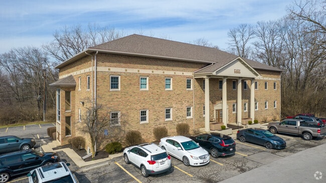
Property Record
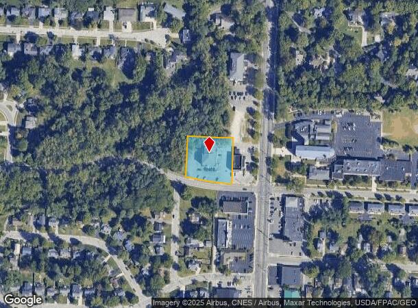
5655 N High St, Worthington, OH 43085
Current Lease Availabilities
NEARBY LISTINGS FOR SALE OR LEASE
Property Detail
5655 N High St
100-002990
Northbrook Sub
Officebuilding
12 W SELBY BLVD .99 ACRES RES A B NORTHBROOK
X
Franklin
39049C0159K
Ohio
2024
0.89 AC
2024
Worthington
006810
Columbus
17,982 SF
Columbus, OH
DEMOGRAPHICS near 5655 N High St
1 Mile
3 Mile
5 Mile
2024 Total Population
11,930
105,193
333,225
2029 Population
11,926
104,582
333,620
Pop Growth 2024-2029
(0.03%)
(0.58%)
+ 0.12%
Average Age
42
40
37
2024 Total Households
5,632
45,777
139,771
HH Growth 2024-2029
+ 0.12%
(0.55%)
+ 0.17%
Median Household Inc
$71,693
$71,292
$67,371
Avg Household Size
2.10
2.20
2.30
2024 Avg HH Vehicles
2.00
2.00
2.00
Median Home Value
$314,536
$292,353
$272,602
Median Year Built
1958
1968
1974
Nearby Places
- Restaurants
- Banks
- Shops
- Fitness
- Groceries
PUBLIC TRANSPORTATION
AIRPORT
John Glenn Columbus International
DRIVE
WALK
Distance
John Glenn Columbus International
21 min
13.9 mi
Rickenbacker International
DRIVE
WALK
Distance
Rickenbacker International
35 min
23.0 mi
Nearby Properties
Address
Land Use
TOTAL SIZE
Lot Size
Zoning
Address
Land Use
TOTAL SIZE
Lot Size
Zoning
182,845 SF
325.61 AC
Address
Land Use
TOTAL SIZE
Lot Size
Zoning
240,144 SF
45.78 AC
Address
Land Use
TOTAL SIZE
Lot Size
Zoning
133,425 SF
20.51 AC
Address
Land Use
TOTAL SIZE
Lot Size
Zoning
320,155 SF
84.68 AC
Address
Land Use
TOTAL SIZE
Lot Size
Zoning
234,504 SF
5.40 AC
Address
Land Use
TOTAL SIZE
Lot Size
Zoning
206,724 SF
7.60 AC
Address
Land Use
TOTAL SIZE
Lot Size
Zoning
561,921 SF
6.81 AC
Address
Land Use
TOTAL SIZE
Lot Size
Zoning
356,770 SF
2.65 AC
Address
Land Use
TOTAL SIZE
Lot Size
Zoning
286,169 SF
11.08 AC
Address
Land Use
TOTAL SIZE
Lot Size
Zoning
425,872 SF
10.05 AC
Address
Land Use
TOTAL SIZE
Lot Size
Zoning
244,602 SF
27.30 AC
Address
Land Use
TOTAL SIZE
Lot Size
Zoning
413,781 SF
78.36 AC
Address
Land Use
TOTAL SIZE
Lot Size
Zoning
187,562 SF
8.76 AC
Address
Land Use
TOTAL SIZE
Lot Size
Zoning
273,112 SF
13.97 AC
Address
Land Use
TOTAL SIZE
Lot Size
Zoning
167,479 SF
36.79 AC
Address
Land Use
TOTAL SIZE
Lot Size
Zoning
86,934 SF
8.80 AC
Address
Land Use
TOTAL SIZE
Lot Size
Zoning
147,582 SF
5.75 AC
Address
Land Use
TOTAL SIZE
Lot Size
Zoning
170,237 SF
97.38 AC
Address
Land Use
TOTAL SIZE
Lot Size
Zoning
368,077 SF
7.87 AC
Address
Land Use
TOTAL SIZE
Lot Size
Zoning
184,756 SF
23.53 AC
Address
Land Use
TOTAL SIZE
Lot Size
Zoning
358,264 SF
10.88 AC
Address
Land Use
TOTAL SIZE
Lot Size
Zoning
148.89 AC
Address
Land Use
TOTAL SIZE
Lot Size
Zoning
177,256 SF
9.33 AC
Address
Land Use
TOTAL SIZE
Lot Size
Zoning
150,468 SF
24.57 AC
Address
Land Use
TOTAL SIZE
Lot Size
Zoning
111,168 SF
19.43 AC
Address
Land Use
TOTAL SIZE
Lot Size
Zoning
138,100 SF
8.38 AC
Address
Land Use
TOTAL SIZE
Lot Size
Zoning
352,730 SF
17.94 AC
Address
Land Use
TOTAL SIZE
Lot Size
Zoning
242,825 SF
3.22 AC
Address
Land Use
TOTAL SIZE
Lot Size
Zoning
187,225 SF
10.28 AC
Address
Land Use
TOTAL SIZE
Lot Size
Zoning
145,386 SF
16.24 AC
The World's #1 Commercial Real Estate Marketplace
Connect with us
© 2025 CoStar Group
The information above has been obtained from sources believed reliable. While we do not doubt its accuracy we have not verified it and make no guarantee, warranty or representation about it. It is your responsibility to independently confirm its accuracy and completeness. Any projections, opinions, assumptions, or estimates used are for example only and do not represent the current or future performance of the property. The value of this transaction to you depends on tax and other factors which should be evaluated by your tax, financial, and legal advisors. You and your advisors should conduct a careful, independent investigation of the property to determine to your satisfaction the suitability of the property for your needs.