Property Record
5655 Petaluma Hill Rd, Santa Rosa, CA 95404
This Property Is For Sale
NEARBY LISTINGS FOR SALE OR LEASE
Property Detail
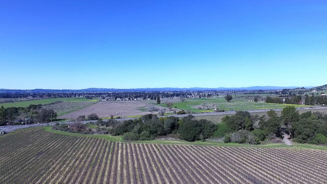
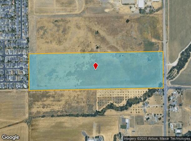
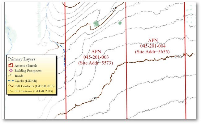
5655 Petaluma Hill Rd
045-201-004
Cotati Rancho
Pasture
UNINCORP COUNTY CA
X
Sonoma
06097C0881E
California
2024
43.57 AC
2025
Santa Rosa
151309
North Bay/Santa Rosa
1,788 SF
Santa Rosa, CA
DEMOGRAPHICS near 5655 Petaluma Hill Rd
1 Mile
3 Mile
5 Mile
2024 Total Population
4,861
48,637
107,034
2029 Population
4,838
48,477
105,934
Pop Growth 2024-2029
(0.47%)
(0.33%)
(1.03%)
Average Age
42
40
40
2024 Total Households
1,878
18,362
38,530
HH Growth 2024-2029
(0.48%)
(0.42%)
(1.09%)
Median Household Inc
$92,259
$90,104
$87,736
Avg Household Size
2.60
2.60
2.70
2024 Avg HH Vehicles
2.00
2.00
2.00
Median Home Value
$715,957
$687,934
$698,944
Median Year Built
1984
1982
1982
Nearby Places
- Restaurants
- Banks
- Shops
- Fitness
- Groceries
PUBLIC TRANSPORTATION
COMMUTER RAIL
Cotati Smart (Main Line - Sonoma Marin Area Rail Transit)
DRIVE
WALK
Distance
Cotati Smart (Main Line - Sonoma Marin Area Rail Transit)
7 min
3.7 mi
Rohnert Park Smart (Main Line - Sonoma Marin Area Rail Transit)
DRIVE
WALK
Distance
Rohnert Park Smart (Main Line - Sonoma Marin Area Rail Transit)
7 min
3.9 mi
AIRPORT
Charles M Schulz - Sonoma County
DRIVE
WALK
Distance
Charles M Schulz - Sonoma County
22 min
14.4 mi
Freight Ports
Port of Richmond
DRIVE
WALK
Distance
Port of Richmond
59 min
42.5 mi
Nearby Properties
Address
Land Use
TOTAL SIZE
Lot Size
Zoning
Address
Land Use
TOTAL SIZE
Lot Size
Zoning
287,036 SF
11.09 AC
MLPD
Address
Land Use
TOTAL SIZE
Lot Size
Zoning
123,512 SF
15.83 AC
CITYRP
Address
Land Use
TOTAL SIZE
Lot Size
Zoning
589,133 SF
36.26 AC
Address
Land Use
TOTAL SIZE
Lot Size
Zoning
184,186 SF
6 AC
MLPD
Address
Land Use
TOTAL SIZE
Lot Size
Zoning
270,526 SF
8.08 AC
Address
Land Use
TOTAL SIZE
Lot Size
Zoning
194,396 SF
7.36 AC
Address
Land Use
TOTAL SIZE
Lot Size
Zoning
10.30 AC
Address
Land Use
TOTAL SIZE
Lot Size
Zoning
187,024 SF
8.64 AC
Address
Land Use
TOTAL SIZE
Lot Size
Zoning
229,265 SF
3.03 AC
RM
Address
Land Use
TOTAL SIZE
Lot Size
Zoning
91,624 SF
4.94 AC
CITYRP
Address
Land Use
TOTAL SIZE
Lot Size
Zoning
180,934 SF
5.55 AC
CITYRP
Address
Land Use
TOTAL SIZE
Lot Size
Zoning
213,331 SF
12.53 AC
CREC
Address
Land Use
TOTAL SIZE
Lot Size
Zoning
165,408 SF
5.40 AC
MLPD
Address
Land Use
TOTAL SIZE
Lot Size
Zoning
149,007 SF
0.25 AC
M1RP
Address
Land Use
TOTAL SIZE
Lot Size
Zoning
90,585 SF
2.28 AC
Address
Land Use
TOTAL SIZE
Lot Size
Zoning
142,759 SF
13.15 AC
CRPD
Address
Land Use
TOTAL SIZE
Lot Size
Zoning
87,286 SF
3.03 AC
Address
Land Use
TOTAL SIZE
Lot Size
Zoning
61,880 SF
2.53 AC
Address
Land Use
TOTAL SIZE
Lot Size
Zoning
107,599 SF
2.98 AC
Address
Land Use
TOTAL SIZE
Lot Size
Zoning
67,584 SF
4.79 AC
CITYRP
Address
Land Use
TOTAL SIZE
Lot Size
Zoning
3.33 AC
MLPD
Address
Land Use
TOTAL SIZE
Lot Size
Zoning
50,880 SF
4.77 AC
CITYRP
Address
Land Use
TOTAL SIZE
Lot Size
Zoning
77,660 SF
2.09 AC
CITYRP
Address
Land Use
TOTAL SIZE
Lot Size
Zoning
3,720 SF
4.11 AC
C2
Address
Land Use
TOTAL SIZE
Lot Size
Zoning
85,844 SF
2.34 AC
MLPD
Address
Land Use
TOTAL SIZE
Lot Size
Zoning
55,387 SF
3.07 AC
CITYRP
Address
Land Use
TOTAL SIZE
Lot Size
Zoning
81,712 SF
5.64 AC
CITYRP
Address
Land Use
TOTAL SIZE
Lot Size
Zoning
69,431 SF
4.69 AC
Address
Land Use
TOTAL SIZE
Lot Size
Zoning
76,420 SF
2.34 AC
Address
Land Use
TOTAL SIZE
Lot Size
Zoning
The World's #1 Commercial Real Estate Marketplace
Connect with us
© 2025 CoStar Group
The information above has been obtained from sources believed reliable. While we do not doubt its accuracy we have not verified it and make no guarantee, warranty or representation about it. It is your responsibility to independently confirm its accuracy and completeness. Any projections, opinions, assumptions, or estimates used are for example only and do not represent the current or future performance of the property. The value of this transaction to you depends on tax and other factors which should be evaluated by your tax, financial, and legal advisors. You and your advisors should conduct a careful, independent investigation of the property to determine to your satisfaction the suitability of the property for your needs.