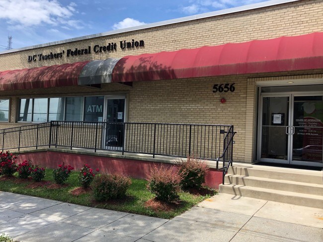
Property Record
5656 3Rd St Ne, Washington, DC 20011

NEARBY LISTINGS FOR SALE OR LEASE
Property Detail
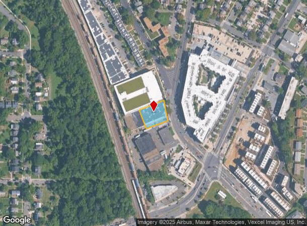
5656 3Rd St Ne
Washington-Arlington-Alexandria, DC-VA-MD-WV
Riggs Park
3710-0195
SQUARE 3710 LOT 0195 NBHD: RIGGS PARK
Financialbuilding
District of Columbia
X
District of Columbia
24033C0110E
195
2025
0.42 AC
2025
NE
009505
Washington, DC
15,830 SF
DEMOGRAPHICS near 5656 3Rd St Ne
1 Mile
3 Mile
5 Mile
2024 Total Population
32,790
301,224
746,918
2029 Population
30,068
282,027
701,457
Pop Growth 2024-2029
(8.30%)
(6.37%)
(6.09%)
Average Age
40
37
37
2024 Total Households
12,722
118,101
317,017
HH Growth 2024-2029
(9.20%)
(7.03%)
(7.10%)
Median Household Inc
$76,879
$85,190
$98,411
Avg Household Size
2.50
2.40
2.20
2024 Avg HH Vehicles
1.00
1.00
1.00
Median Home Value
$565,439
$633,367
$696,222
Median Year Built
1952
1953
1957
Nearby Places
Map Layers
Map Styles
 Street
 Aerial
- Restaurants
- Banks
- Shops
- Fitness
- Groceries
PUBLIC TRANSPORTATION
TRANSIT/SUBWAY
Fort Totten (Green Line - Washington Metropolitan Area Transit Authority Metrorail (Metrorail), Red Line - Washington Metropolitan Area Transit Authority Metrorail (Metrorail), Yellow Line - Washington Metropolitan Area Transit Authority Metrorail (Metrorail))
DRIVE
WALK
Distance
Fort Totten (Green Line - Washington Metropolitan Area Transit Authority Metrorail (Metrorail), Red Line - Washington Metropolitan Area Transit Authority Metrorail (Metrorail), Yellow Line - Washington Metropolitan Area Transit Authority Metrorail (Metrorail))
2 min
13 min
0.6 mi
COMMUTER RAIL
Silver Spring (Brunswick Line - Maryland Area Regional Commuter Trains (The MARC))
DRIVE
WALK
Distance
Silver Spring (Brunswick Line - Maryland Area Regional Commuter Trains (The MARC))
11 min
3.5 mi
DRIVE
WALK
Distance
9 min
4.6 mi
AIRPORT
Ronald Reagan Washington Ntl
DRIVE
WALK
Distance
Ronald Reagan Washington Ntl
20 min
10.0 mi
Baltimore/Washington International Thurgood Marshall
DRIVE
WALK
Distance
Baltimore/Washington International Thurgood Marshall
44 min
31.1 mi
Washington Dulles International
DRIVE
WALK
Distance
Washington Dulles International
53 min
32.8 mi
Freight Ports
Port of Baltimore
DRIVE
WALK
Distance
Port of Baltimore
48 min
33.8 mi
SALE & LEASE HISTORY
LISTING DATE
SALE/LEASE

Apr 15, 2019
For Lease
Nearby Properties
Address
Land Use
TOTAL SIZE
Lot Size
Zoning
Address
Land Use
TOTAL SIZE
Lot Size
Zoning
1,583,364 SF
276.66 AC
UNZONED
Address
Land Use
TOTAL SIZE
Lot Size
Zoning
1,562,988 SF
15.33 AC
MU-10 (IZ+
Address
Land Use
TOTAL SIZE
Lot Size
Zoning
95.32 AC
RA-1
Address
Land Use
TOTAL SIZE
Lot Size
Zoning
1,835,827 SF
34.66 AC
UNZONED
Address
Land Use
TOTAL SIZE
Lot Size
Zoning
791,730 SF
37.44 AC
RA-1
Address
Land Use
TOTAL SIZE
Lot Size
Zoning
1,095,275 SF
30.70 AC
MU-4;RA-2
Address
Land Use
TOTAL SIZE
Lot Size
Zoning
823,802 SF
7.30 AC
MU-2
Address
Land Use
TOTAL SIZE
Lot Size
Zoning
256,187 SF
8.97 AC
RA-2
Address
Land Use
TOTAL SIZE
Lot Size
Zoning
520,000 SF
2.65 AC
MU-10;RA-5
Address
Land Use
TOTAL SIZE
Lot Size
Zoning
248,643 SF
8.66 AC
RA-1
Address
Land Use
TOTAL SIZE
Lot Size
Zoning
505,000 SF
1.97 AC
CR8.0
Address
Land Use
TOTAL SIZE
Lot Size
Zoning
1,201,133 SF
41.56 AC
RTOHC
Address
Land Use
TOTAL SIZE
Lot Size
Zoning
869,190 SF
4.97 AC
RA-1
Address
Land Use
TOTAL SIZE
Lot Size
Zoning
302,861 SF
16.30 AC
R-1A
Address
Land Use
TOTAL SIZE
Lot Size
Zoning
41.12 AC
RA-1
Address
Land Use
TOTAL SIZE
Lot Size
Zoning
400,000 SF
0.93 AC
CR5.0
Address
Land Use
TOTAL SIZE
Lot Size
Zoning
326,985 SF
1.13 AC
MU-6B
Address
Land Use
TOTAL SIZE
Lot Size
Zoning
309,621 SF
1.98 AC
Address
Land Use
TOTAL SIZE
Lot Size
Zoning
202,500 SF
0.53 AC
MU-10 (IZ+
Address
Land Use
TOTAL SIZE
Lot Size
Zoning
357,398 SF
0.72 AC
MU-5A
Address
Land Use
TOTAL SIZE
Lot Size
Zoning
319,450 SF
0.71 AC
MU-10
Address
Land Use
TOTAL SIZE
Lot Size
Zoning
169,500 SF
9.14 AC
RA-1
Address
Land Use
TOTAL SIZE
Lot Size
Zoning
492,835 SF
21.61 AC
RA-1
Address
Land Use
TOTAL SIZE
Lot Size
Zoning
4,924 SF
53.06 AC
R-3
Address
Land Use
TOTAL SIZE
Lot Size
Zoning
484,988 SF
1.87 AC
MU-4
Address
Land Use
TOTAL SIZE
Lot Size
Zoning
298,452 SF
0.93 AC
MU-10
Address
Land Use
TOTAL SIZE
Lot Size
Zoning
39,276 SF
22.97 AC
R-1A/FH
Address
Land Use
TOTAL SIZE
Lot Size
Zoning
305,711 SF
0.84 AC
RA-2
Address
Land Use
TOTAL SIZE
Lot Size
Zoning
185,000 SF
4.30 AC
RA-2;RA-4
Address
Land Use
TOTAL SIZE
Lot Size
Zoning
12,498 SF
7.36 AC
RF-1
The World's #1 Commercial Real Estate Marketplace
Connect with us
© 2025 CoStar Group
The information above has been obtained from sources believed reliable. While we do not doubt its accuracy we have not verified it and make no guarantee, warranty or representation about it. It is your responsibility to independently confirm its accuracy and completeness. Any projections, opinions, assumptions, or estimates used are for example only and do not represent the current or future performance of the property. The value of this transaction to you depends on tax and other factors which should be evaluated by your tax, financial, and legal advisors. You and your advisors should conduct a careful, independent investigation of the property to determine to your satisfaction the suitability of the property for your needs.