Property Record
5659 Ogeechee Rd, Savannah, GA 31405

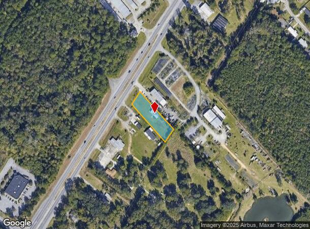
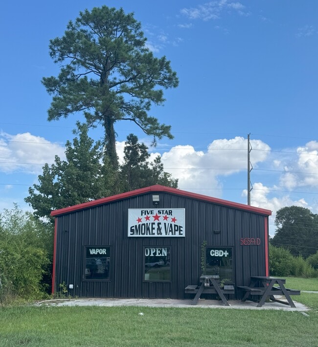
This Property Is For Sale
NEARBY LISTINGS FOR SALE OR LEASE
Property Detail
5659 Ogeechee Rd
Savannah, GA
Hwy 17 Quacco
1099107031
PORTION OF LOT 4 SARANAC TRACT FRONTING ON OGEECHE E
Publicstorage
Chatham
X
Georgia
13051C0140G
4
2024
0.73 AC
2025
Outlying Chatham County
010815
Savannah
1,800 SF
DEMOGRAPHICS near 5659 Ogeechee Rd
1 Mile
3 Mile
5 Mile
2024 Total Population
6,007
23,835
68,098
2029 Population
6,207
24,909
70,879
Pop Growth 2024-2029
+ 3.33%
+ 4.51%
+ 4.08%
Average Age
38
39
38
2024 Total Households
2,273
9,435
26,298
HH Growth 2024-2029
+ 3.43%
+ 4.58%
+ 4.29%
Median Household Inc
$82,698
$74,561
$65,993
Avg Household Size
2.60
2.50
2.40
2024 Avg HH Vehicles
2.00
2.00
2.00
Median Home Value
$199,373
$221,228
$205,279
Median Year Built
2004
2003
2001
Nearby Places
Map Layers
Map Styles
 Street
 Aerial
- Restaurants
- Banks
- Shops
- Fitness
- Groceries
PUBLIC TRANSPORTATION
COMMUTER RAIL
Savannah (Palmetto - Amtrak, Silver Meteor - Amtrak, Silver Star - Amtrak)
DRIVE
WALK
Distance
Savannah (Palmetto - Amtrak, Silver Meteor - Amtrak, Silver Star - Amtrak)
13 min
6.8 mi
AIRPORT
Savannah/Hilton Head International
DRIVE
WALK
Distance
Savannah/Hilton Head International
17 min
8.0 mi
Freight Ports
Georgia Ports - Savannah
DRIVE
WALK
Distance
Georgia Ports - Savannah
19 min
10.0 mi
Nearby Properties
Address
Land Use
TOTAL SIZE
Lot Size
Zoning
Address
Land Use
TOTAL SIZE
Lot Size
Zoning
99.50 AC
M
Address
Land Use
TOTAL SIZE
Lot Size
Zoning
70.49 AC
M
Address
Land Use
TOTAL SIZE
Lot Size
Zoning
942,210 SF
50.60 AC
Address
Land Use
TOTAL SIZE
Lot Size
Zoning
34,980 SF
23.34 AC
PR3-16
Address
Land Use
TOTAL SIZE
Lot Size
Zoning
33,510 SF
22.30 AC
PRM16
Address
Land Use
TOTAL SIZE
Lot Size
Zoning
12,560 SF
14.82 AC
PUD
Address
Land Use
TOTAL SIZE
Lot Size
Zoning
21.13 AC
PUDC
Address
Land Use
TOTAL SIZE
Lot Size
Zoning
6,580 SF
42.03 AC
PUDM-12
Address
Land Use
TOTAL SIZE
Lot Size
Zoning
413,230 SF
39.64 AC
M-CO
Address
Land Use
TOTAL SIZE
Lot Size
Zoning
8,208 SF
48.30 AC
PUDC
Address
Land Use
TOTAL SIZE
Lot Size
Zoning
26,124 SF
12 AC
BC1
Address
Land Use
TOTAL SIZE
Lot Size
Zoning
355,570 SF
25.41 AC
PIL
Address
Land Use
TOTAL SIZE
Lot Size
Zoning
41,592 SF
20.47 AC
PUDC
Address
Land Use
TOTAL SIZE
Lot Size
Zoning
12,560 SF
22.94 AC
PUD
Address
Land Use
TOTAL SIZE
Lot Size
Zoning
3,848 SF
9.14 AC
PBG
Address
Land Use
TOTAL SIZE
Lot Size
Zoning
6,278 SF
24.47 AC
RA
Address
Land Use
TOTAL SIZE
Lot Size
Zoning
28.95 AC
M
Address
Land Use
TOTAL SIZE
Lot Size
Zoning
79.49 AC
I-H
Address
Land Use
TOTAL SIZE
Lot Size
Zoning
11,784 SF
9.79 AC
PUDC
Address
Land Use
TOTAL SIZE
Lot Size
Zoning
3.69 AC
BC1
Address
Land Use
TOTAL SIZE
Lot Size
Zoning
142,560 SF
6.67 AC
PUDCC
Address
Land Use
TOTAL SIZE
Lot Size
Zoning
32,712 SF
0.59 AC
Address
Land Use
TOTAL SIZE
Lot Size
Zoning
11,784 SF
9.37 AC
PUDC
Address
Land Use
TOTAL SIZE
Lot Size
Zoning
13,225 SF
18.59 AC
PUDCC
Address
Land Use
TOTAL SIZE
Lot Size
Zoning
88,000 SF
9.62 AC
PIL
Address
Land Use
TOTAL SIZE
Lot Size
Zoning
9,170 SF
10 AC
PUDM6
Address
Land Use
TOTAL SIZE
Lot Size
Zoning
79,700 SF
4.67 AC
PUDCC
Address
Land Use
TOTAL SIZE
Lot Size
Zoning
70,384 SF
8.78 AC
PUDC
Address
Land Use
TOTAL SIZE
Lot Size
Zoning
8.58 AC
Address
Land Use
TOTAL SIZE
Lot Size
Zoning
36,256 SF
15.81 AC
PUDC
The World's #1 Commercial Real Estate Marketplace
Connect with us
© 2026 CoStar Group
The information above has been obtained from sources believed reliable. While we do not doubt its accuracy we have not verified it and make no guarantee, warranty or representation about it. It is your responsibility to independently confirm its accuracy and completeness. Any projections, opinions, assumptions, or estimates used are for example only and do not represent the current or future performance of the property. The value of this transaction to you depends on tax and other factors which should be evaluated by your tax, financial, and legal advisors. You and your advisors should conduct a careful, independent investigation of the property to determine to your satisfaction the suitability of the property for your needs.