Property Record
566 Balltown Rd, Schenectady, NY 12304
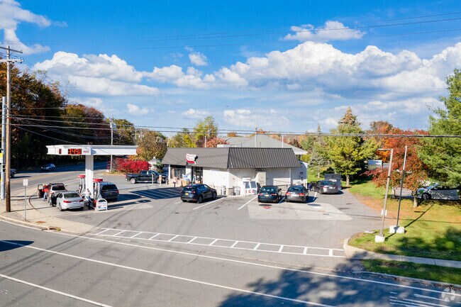

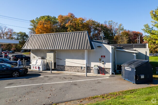
Property Detail
566 Balltown Rd
060-000-0001-010-001-0000
SCHENECTADY
Servicestationmarket
New York
CN
10.001
B and X Area of moderate flood hazard, usually the area between the limits of the 100-year and 500-year floods.
0.31 AC
2025
Outer Schenectady County
2025
Albany/Schenectady/Troy
031902
Albany-Schenectady-Troy, NY
2,122 SF
NEARBY LISTINGS FOR SALE OR LEASE
DEMOGRAPHICS near 566 Balltown Rd
1 mile
3 mile
5 mile
2025 Total Population
7,035
81,459
154,193
2030 Population
7,094
82,461
156,587
Pop Growth 2025-2030
+ 0.84%
+ 1.23%
+ 1.55%
Average Age
43
40
40
2025 Total Households
2,916
32,019
62,253
HH Growth 2025-2030
+ 0.69%
+ 1.35%
+ 1.67%
Median Household Inc
$96,974
$74,141
$75,858
Avg Household Size
2.30
2.40
2.30
2025 Avg HH Vehicles
2.00
2.00
2.00
Median Home Value
$199,579
$245,632
$254,832
Median Year Built
1956
1953
1956
Nearby Places
Map Layers
Map Styles
 Street
 Aerial
Layers
 Traffic
 Biking
Places
Listings with unknown addresses are not visible on the map
- Restaurants
- Banks
- Shops
- Fitness
- Groceries
PUBLIC TRANSPORTATION
AIRPORT
Albany International
Drive
Walk
Distance
Albany International
16 min
7.8 mi
Freight Ports
Albany, NY Port
Drive
Walk
Distance
Albany, NY Port
30 min
18.9 mi
Nearby Properties
Address
Land Use
TOTAL SIZE
Lot Size
Zoning
Address
Land Use
TOTAL SIZE
Lot Size
Zoning
583,211 SF
9.95 AC
03 - MULTI
Address
Land Use
TOTAL SIZE
Lot Size
Zoning
6,733 SF
100 AC
03 - MULTI
Address
Land Use
TOTAL SIZE
Lot Size
Zoning
11,700 SF
43.80 AC
R2
Address
Land Use
TOTAL SIZE
Lot Size
Zoning
194,403 SF
315.80 AC
06 - INDUS
Address
Land Use
TOTAL SIZE
Lot Size
Zoning
184,878 SF
15.58 AC
03 - MULTI
Address
Land Use
TOTAL SIZE
Lot Size
Zoning
120,755 SF
33.88 AC
R1
Address
Land Use
TOTAL SIZE
Lot Size
Zoning
102,862 SF
32.45 AC
CS
Address
Land Use
TOTAL SIZE
Lot Size
Zoning
138,014 SF
4 AC
02 - SINGL
Address
Land Use
TOTAL SIZE
Lot Size
Zoning
123,030 SF
7.21 AC
03 - MULTI
Address
Land Use
TOTAL SIZE
Lot Size
Zoning
249,801 SF
54.35 AC
R1
Address
Land Use
TOTAL SIZE
Lot Size
Zoning
234,485 SF
42.50 AC
02 - SINGL
Address
Land Use
TOTAL SIZE
Lot Size
Zoning
284,171 SF
16.40 AC
03 - MULTI
Address
Land Use
TOTAL SIZE
Lot Size
Zoning
181,230 SF
1.02 AC
05 - COMME
Address
Land Use
TOTAL SIZE
Lot Size
Zoning
67,526 SF
9.40 AC
R1
Address
Land Use
TOTAL SIZE
Lot Size
Zoning
4,680 SF
11.39 AC
CH
Address
Land Use
TOTAL SIZE
Lot Size
Zoning
117,074 SF
25.30 AC
CN
Address
Land Use
TOTAL SIZE
Lot Size
Zoning
93,846 SF
3 AC
R2
Address
Land Use
TOTAL SIZE
Lot Size
Zoning
Address
Land Use
TOTAL SIZE
Lot Size
Zoning
8,662 SF
4.97 AC
Address
Land Use
TOTAL SIZE
Lot Size
Zoning
45,896 SF
10.20 AC
03 - MULTI
Address
Land Use
TOTAL SIZE
Lot Size
Zoning
135,155 SF
6.43 AC
03 - MULTI
Address
Land Use
TOTAL SIZE
Lot Size
Zoning
303 SF
29.20 AC
CN
Address
Land Use
TOTAL SIZE
Lot Size
Zoning
202,050 SF
20.75 AC
B-2
Address
Land Use
TOTAL SIZE
Lot Size
Zoning
79,041 SF
13.20 AC
CN
Address
Land Use
TOTAL SIZE
Lot Size
Zoning
7,216 SF
15.90 AC
03 - MULTI
Address
Land Use
TOTAL SIZE
Lot Size
Zoning
58,918 SF
4.35 AC
CN
Address
Land Use
TOTAL SIZE
Lot Size
Zoning
120,373 SF
9.68 AC
CS
Address
Land Use
TOTAL SIZE
Lot Size
Zoning
97,440 SF
8.15 AC
B-2
Address
Land Use
TOTAL SIZE
Lot Size
Zoning
111,915 SF
15.04 AC
05 - COMME
Address
Land Use
TOTAL SIZE
Lot Size
Zoning
117 AC
06 - INDUS
The World's #1 Commercial Real Estate Marketplace
Connect with us
© 2026 CoStar Group
The information above has been obtained from sources believed reliable. While we do not doubt its accuracy we have not verified it and make no guarantee, warranty or representation about it. It is your responsibility to independently confirm its accuracy and completeness. Any projections, opinions, assumptions, or estimates used are for example only and do not represent the current or future performance of the property. The value of this transaction to you depends on tax and other factors which should be evaluated by your tax, financial, and legal advisors. You and your advisors should conduct a careful, independent investigation of the property to determine to your satisfaction the suitability of the property for your needs.