Property Record
566 Interstate 35, Milford, TX 76670
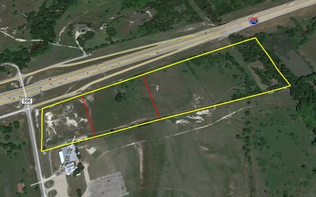


This Property Is For Sale
Property Detail
566 Interstate 35
Dallas-Fort Worth-Arlington, TX
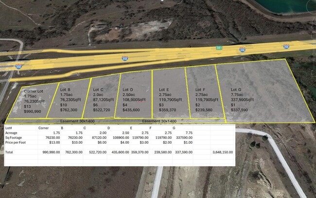
551 E JOCELYN 21.21 ACRES
185951
ELLIS
Agriculturalland
Texas
A Areas with a 1% annual chance of flooding and a 26% chance of flooding over the life of a 30-year mortgage.
21.21 AC
2024
Ellis County
2025
Dallas/Ft Worth
061000
NEARBY LISTINGS FOR SALE OR LEASE
DEMOGRAPHICS near 566 Interstate 35
1 mile
3 mile
5 mile
2025 Total Population
534
1,086
2,973
2030 Population
613
1,245
3,396
Pop Growth 2025-2030
+ 14.79%
+ 14.64%
+ 14.23%
Average Age
41
41
41
2025 Total Households
193
393
1,080
HH Growth 2025-2030
+ 15.03%
+ 14.76%
+ 14.26%
Median Household Inc
$82,692
$81,731
$62,941
Avg Household Size
2.80
2.80
2.70
2025 Avg HH Vehicles
2.00
2.00
2.00
Median Home Value
$356,818
$355,555
$269,491
Median Year Built
1979
1980
1986
Nearby Places
Map Layers
Map Styles
 Street
 Aerial
Transit
 Traffic
 Biking
Places
Listings with unknown addresses are not visible on the map
- Restaurants
- Banks
- Shops
- Fitness
- Groceries
Nearby Properties
Address
Land Use
TOTAL SIZE
Lot Size
Zoning
Address
Land Use
TOTAL SIZE
Lot Size
Zoning
1,280 SF
35 AC
Address
Land Use
TOTAL SIZE
Lot Size
Zoning
13,044 SF
15.45 AC
Address
Land Use
TOTAL SIZE
Lot Size
Zoning
76,870 SF
38.89 AC
Address
Land Use
TOTAL SIZE
Lot Size
Zoning
16,588 SF
387.48 AC
Address
Land Use
TOTAL SIZE
Lot Size
Zoning
20,665 SF
4.96 AC
Address
Land Use
TOTAL SIZE
Lot Size
Zoning
5,058 SF
44.67 AC
Address
Land Use
TOTAL SIZE
Lot Size
Zoning
35,272 SF
64.55 AC
Address
Land Use
TOTAL SIZE
Lot Size
Zoning
7,828 SF
664.39 AC
Address
Land Use
TOTAL SIZE
Lot Size
Zoning
6,338 SF
1,915.01 AC
Address
Land Use
TOTAL SIZE
Lot Size
Zoning
4,726 SF
94.41 AC
Address
Land Use
TOTAL SIZE
Lot Size
Zoning
1,560 SF
95.27 AC
Address
Land Use
TOTAL SIZE
Lot Size
Zoning
10,810 SF
0.81 AC
Address
Land Use
TOTAL SIZE
Lot Size
Zoning
1,400 SF
144.89 AC
Address
Land Use
TOTAL SIZE
Lot Size
Zoning
52.52 AC
Address
Land Use
TOTAL SIZE
Lot Size
Zoning
4,071 SF
5.60 AC
Address
Land Use
TOTAL SIZE
Lot Size
Zoning
44.10 AC
Address
Land Use
TOTAL SIZE
Lot Size
Zoning
6,926 SF
27.28 AC
Address
Land Use
TOTAL SIZE
Lot Size
Zoning
11 SF
0.96 AC
Address
Land Use
TOTAL SIZE
Lot Size
Zoning
3,327 SF
11.72 AC
Address
Land Use
TOTAL SIZE
Lot Size
Zoning
35.18 AC
Address
Land Use
TOTAL SIZE
Lot Size
Zoning
1 SF
0.45 AC
Address
Land Use
TOTAL SIZE
Lot Size
Zoning
70.90 AC
Address
Land Use
TOTAL SIZE
Lot Size
Zoning
2,016 SF
10 AC
Address
Land Use
TOTAL SIZE
Lot Size
Zoning
3,444 SF
14.70 AC
Address
Land Use
TOTAL SIZE
Lot Size
Zoning
2,809 SF
10 AC
Address
Land Use
TOTAL SIZE
Lot Size
Zoning
2,918 SF
10 AC
Address
Land Use
TOTAL SIZE
Lot Size
Zoning
2,681 SF
7.50 AC
Address
Land Use
TOTAL SIZE
Lot Size
Zoning
11,680 SF
0.24 AC
Address
Land Use
TOTAL SIZE
Lot Size
Zoning
2,132 SF
54.63 AC
The World's #1 Commercial Real Estate Marketplace
Connect with us
© 2026 CoStar Group
The information above has been obtained from sources believed reliable. While we do not doubt its accuracy we have not verified it and make no guarantee, warranty or representation about it. It is your responsibility to independently confirm its accuracy and completeness. Any projections, opinions, assumptions, or estimates used are for example only and do not represent the current or future performance of the property. The value of this transaction to you depends on tax and other factors which should be evaluated by your tax, financial, and legal advisors. You and your advisors should conduct a careful, independent investigation of the property to determine to your satisfaction the suitability of the property for your needs.