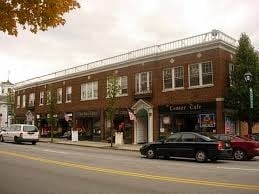
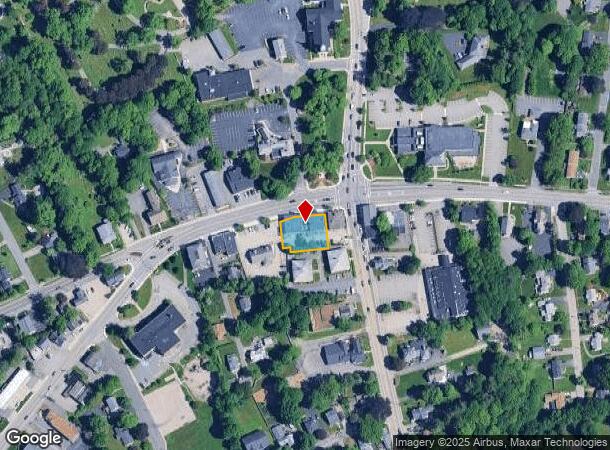
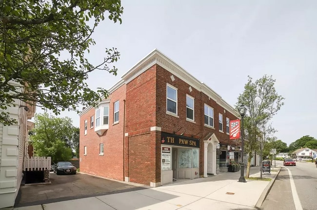
Property Record
566 Main St, Shrewsbury, MA 01545
Current Lease Availabilities
NEARBY LISTINGS FOR SALE OR LEASE
Property Detail
566 Main St
Commercialofficeresidentialmixeduse
Worcester
X
Massachusetts
25027C0637F
0.29 AC
2025
Worcester Metro
2025
Boston
739300
Worcester, MA-CT
10,324 SF
SHRE-000022-000000-169000
DEMOGRAPHICS near 566 Main St
1 Mile
3 Mile
5 Mile
2024 Total Population
7,696
49,031
154,593
2029 Population
7,772
49,306
153,829
Pop Growth 2024-2029
+ 0.99%
+ 0.56%
(0.49%)
Average Age
44
41
40
2024 Total Households
2,939
18,712
60,344
HH Growth 2024-2029
+ 1.22%
+ 0.66%
(0.48%)
Median Household Inc
$124,456
$112,328
$85,551
Avg Household Size
2.60
2.60
2.50
2024 Avg HH Vehicles
2.00
2.00
2.00
Median Home Value
$511,422
$493,335
$400,079
Median Year Built
1973
1980
1966
Nearby Places
- Restaurants
- Banks
- Shops
- Fitness
- Groceries
PUBLIC TRANSPORTATION
COMMUTER RAIL
Grafton (Framingham/Worcester Line - Massachusetts Bay Transportation Authority Commuter Rail (Purple Line))
DRIVE
WALK
Distance
Grafton (Framingham/Worcester Line - Massachusetts Bay Transportation Authority Commuter Rail (Purple Line))
10 min
4.8 mi
Worcester (Framingham/Worcester Line - Massachusetts Bay Transportation Authority Commuter Rail (Purple Line))
DRIVE
WALK
Distance
Worcester (Framingham/Worcester Line - Massachusetts Bay Transportation Authority Commuter Rail (Purple Line))
10 min
5.1 mi
AIRPORT
Worcester Regional
DRIVE
WALK
Distance
Worcester Regional
21 min
10.4 mi
Freight Ports
Port of Boston
DRIVE
WALK
Distance
Port of Boston
58 min
39.0 mi
Nearby Properties
Address
Land Use
TOTAL SIZE
Lot Size
Zoning
Address
Land Use
TOTAL SIZE
Lot Size
Zoning
42.01 AC
I
Address
Land Use
TOTAL SIZE
Lot Size
Zoning
68.85 AC
OFF-RE
Address
Land Use
TOTAL SIZE
Lot Size
Zoning
26,152 SF
7.97 AC
COM BU
Address
Land Use
TOTAL SIZE
Lot Size
Zoning
22.40 AC
COM BU
Address
Land Use
TOTAL SIZE
Lot Size
Zoning
362,937 SF
91.58 AC
Address
Land Use
TOTAL SIZE
Lot Size
Zoning
23.65 AC
RUR A
Address
Land Use
TOTAL SIZE
Lot Size
Zoning
295,000 SF
194.17 AC
RUR B
Address
Land Use
TOTAL SIZE
Lot Size
Zoning
16.01 AC
COM BU
Address
Land Use
TOTAL SIZE
Lot Size
Zoning
Address
Land Use
TOTAL SIZE
Lot Size
Zoning
412,272 SF
42.44 AC
OFF-RE
Address
Land Use
TOTAL SIZE
Lot Size
Zoning
142,438 SF
14.26 AC
RES B-
Address
Land Use
TOTAL SIZE
Lot Size
Zoning
21.04 AC
APT 99
Address
Land Use
TOTAL SIZE
Lot Size
Zoning
174,807 SF
32.43 AC
RES B-
Address
Land Use
TOTAL SIZE
Lot Size
Zoning
203,184 SF
0.21 AC
MF-1
Address
Land Use
TOTAL SIZE
Lot Size
Zoning
491,632 SF
1.59 AC
RL-7
Address
Land Use
TOTAL SIZE
Lot Size
Zoning
9.70 AC
COM BU
Address
Land Use
TOTAL SIZE
Lot Size
Zoning
154,200 SF
4.87 AC
BL-1
Address
Land Use
TOTAL SIZE
Lot Size
Zoning
0.99 AC
MF-1 9
Address
Land Use
TOTAL SIZE
Lot Size
Zoning
118,381 SF
12.61 AC
RG-5
Address
Land Use
TOTAL SIZE
Lot Size
Zoning
120,046 SF
6.90 AC
RG-5
Address
Land Use
TOTAL SIZE
Lot Size
Zoning
118,682 SF
7.33 AC
RG-5
Address
Land Use
TOTAL SIZE
Lot Size
Zoning
217,500 SF
51.71 AC
LIM CO
Address
Land Use
TOTAL SIZE
Lot Size
Zoning
1,839.82 AC
Address
Land Use
TOTAL SIZE
Lot Size
Zoning
373,550 SF
29.05 AC
Address
Land Use
TOTAL SIZE
Lot Size
Zoning
99,908 SF
18.28 AC
RUR AA
Address
Land Use
TOTAL SIZE
Lot Size
Zoning
102,181 SF
38.62 AC
RES B-
Address
Land Use
TOTAL SIZE
Lot Size
Zoning
55,178 SF
5 AC
COM BU
Address
Land Use
TOTAL SIZE
Lot Size
Zoning
15.26 AC
COM BU
Address
Land Use
TOTAL SIZE
Lot Size
Zoning
11.84 AC
COM BU
Address
Land Use
TOTAL SIZE
Lot Size
Zoning
12.96 AC
MF-1
The World's #1 Commercial Real Estate Marketplace
Connect with us
© 2025 CoStar Group
The information above has been obtained from sources believed reliable. While we do not doubt its accuracy we have not verified it and make no guarantee, warranty or representation about it. It is your responsibility to independently confirm its accuracy and completeness. Any projections, opinions, assumptions, or estimates used are for example only and do not represent the current or future performance of the property. The value of this transaction to you depends on tax and other factors which should be evaluated by your tax, financial, and legal advisors. You and your advisors should conduct a careful, independent investigation of the property to determine to your satisfaction the suitability of the property for your needs.