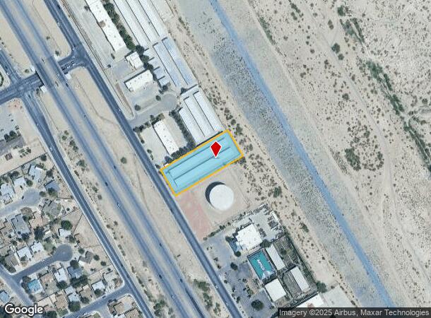
Property Record
560 N Telshor Blvd, Las Cruces, NM 88011
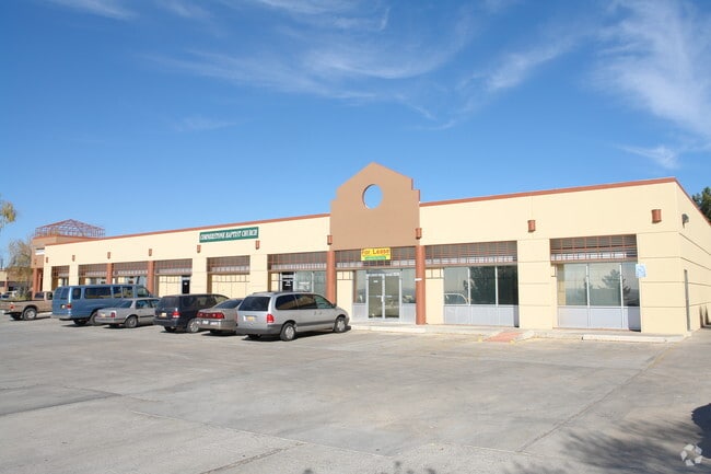
This Property Is For Sale
NEARBY LISTINGS FOR SALE OR LEASE
Property Detail
560 N Telshor Blvd
Las Cruces, NM
Ameriwest Subdivision No 2
02-21159
SUBD: AMERIWEST SUBDIVISION NO 2 REPLAT NO 2 (BK 16 PG 188 - 8921596) LOT: 4 S: 8 T: 23S R: 2E
Commercialacreage
Dona Ana
X
New Mexico
35013C1084G
4
2024
1.17 AC
2025
Las Cruces/Alamogordo
0012011086
Other Market Areas
21,300 SF
DEMOGRAPHICS near 560 N Telshor Blvd
1 Mile
3 Mile
5 Mile
2024 Total Population
10,108
81,915
132,625
2029 Population
10,636
86,247
139,901
Pop Growth 2024-2029
+ 5.22%
+ 5.29%
+ 5.49%
Average Age
41
38
38
2024 Total Households
4,223
35,182
53,212
HH Growth 2024-2029
+ 5.42%
+ 5.36%
+ 5.62%
Median Household Inc
$42,688
$40,327
$47,104
Avg Household Size
2.30
2.30
2.40
2024 Avg HH Vehicles
2.00
2.00
2.00
Median Home Value
$163,079
$179,740
$195,304
Median Year Built
1984
1984
1988
Nearby Places
Map Layers
Map Styles
 Street
 Aerial
- Restaurants
- Banks
- Shops
- Fitness
- Groceries
Nearby Properties
Address
Land Use
TOTAL SIZE
Lot Size
Zoning
Address
Land Use
TOTAL SIZE
Lot Size
Zoning
266,671 SF
23.96 AC
PUD
Address
Land Use
TOTAL SIZE
Lot Size
Zoning
198,290 SF
33.76 AC
R4
Address
Land Use
TOTAL SIZE
Lot Size
Zoning
413,000 SF
R4
Address
Land Use
TOTAL SIZE
Lot Size
Zoning
106,866 SF
10.61 AC
R1
Address
Land Use
TOTAL SIZE
Lot Size
Zoning
240,030 SF
14.74 AC
R4
Address
Land Use
TOTAL SIZE
Lot Size
Zoning
280,731 SF
15.55 AC
PUD
Address
Land Use
TOTAL SIZE
Lot Size
Zoning
29,466 SF
1.33 AC
C2
Address
Land Use
TOTAL SIZE
Lot Size
Zoning
78,452 SF
60 AC
A2
Address
Land Use
TOTAL SIZE
Lot Size
Zoning
49 AC
C1
Address
Land Use
TOTAL SIZE
Lot Size
Zoning
66,410 SF
7 AC
PUD
Address
Land Use
TOTAL SIZE
Lot Size
Zoning
6,232 SF
22.74 AC
C2
Address
Land Use
TOTAL SIZE
Lot Size
Zoning
154,592 SF
14.12 AC
A2
Address
Land Use
TOTAL SIZE
Lot Size
Zoning
170,972 SF
16.38 AC
R4
Address
Land Use
TOTAL SIZE
Lot Size
Zoning
195,560 SF
25.05 AC
PUD
Address
Land Use
TOTAL SIZE
Lot Size
Zoning
135,605 SF
6 AC
PUD
Address
Land Use
TOTAL SIZE
Lot Size
Zoning
213,046 SF
33.55 AC
R1
Address
Land Use
TOTAL SIZE
Lot Size
Zoning
98,015 SF
7.85 AC
A1
Address
Land Use
TOTAL SIZE
Lot Size
Zoning
394,043 SF
26.74 AC
C2
Address
Land Use
TOTAL SIZE
Lot Size
Zoning
139,122 SF
6.12 AC
C2
Address
Land Use
TOTAL SIZE
Lot Size
Zoning
463,811 SF
36.43 AC
C2
Address
Land Use
TOTAL SIZE
Lot Size
Zoning
52,991 SF
5.95 AC
C2
Address
Land Use
TOTAL SIZE
Lot Size
Zoning
49,295 SF
6.29 AC
R3
Address
Land Use
TOTAL SIZE
Lot Size
Zoning
7,483 SF
16.15 AC
PUD
Address
Land Use
TOTAL SIZE
Lot Size
Zoning
65,535 SF
5.64 AC
R1
Address
Land Use
TOTAL SIZE
Lot Size
Zoning
14.47 AC
R4
Address
Land Use
TOTAL SIZE
Lot Size
Zoning
27,528 SF
4.65 AC
R1
Address
Land Use
TOTAL SIZE
Lot Size
Zoning
74,724 SF
8 AC
PUD
Address
Land Use
TOTAL SIZE
Lot Size
Zoning
132,179 SF
14.24 AC
M1
Address
Land Use
TOTAL SIZE
Lot Size
Zoning
42,295 SF
7.45 AC
C2
The World's #1 Commercial Real Estate Marketplace
Connect with us
© 2025 CoStar Group
The information above has been obtained from sources believed reliable. While we do not doubt its accuracy we have not verified it and make no guarantee, warranty or representation about it. It is your responsibility to independently confirm its accuracy and completeness. Any projections, opinions, assumptions, or estimates used are for example only and do not represent the current or future performance of the property. The value of this transaction to you depends on tax and other factors which should be evaluated by your tax, financial, and legal advisors. You and your advisors should conduct a careful, independent investigation of the property to determine to your satisfaction the suitability of the property for your needs.