Property Record
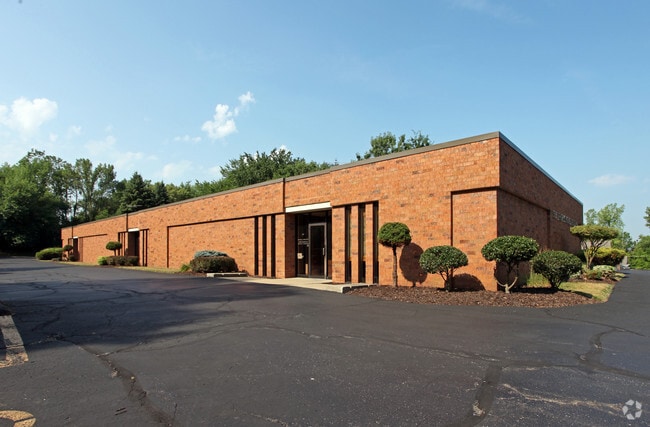
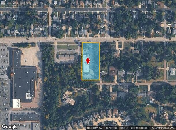
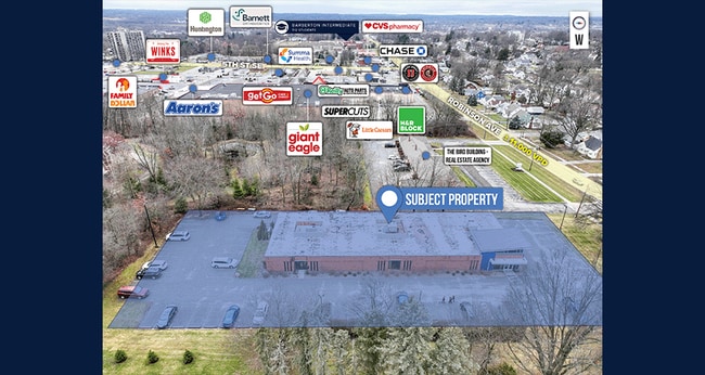
566 Robinson Ave, Barberton, OH 44203
NEARBY LISTINGS FOR SALE OR LEASE
Property Detail
566 Robinson Ave
Akron, OH
Coventry
01-11454
TR 15 LOT 17 S OF ROBINSON AVE CRA PCL 0116986
Medicalbuilding
Summit
X
Ohio
39153C0189F
17
2023
1.57 AC
2025
Akron
510302
Cleveland
10,092 SF
DEMOGRAPHICS near 566 Robinson Ave
1 mile
3 mile
5 mile
2024 Total Population
9,036
48,525
112,251
2029 Population
8,919
48,134
111,371
Pop Growth 2024-2029
(1.29%)
(0.81%)
(0.78%)
Average Age
44
42
42
2024 Total Households
4,090
21,288
48,400
HH Growth 2024-2029
(1.34%)
(0.84%)
(0.83%)
Median Household Inc
$42,509
$47,567
$48,395
Avg Household Size
2.10
2.20
2.20
2024 Avg HH Vehicles
1.00
2.00
2.00
Median Home Value
$130,851
$112,057
$123,568
Median Year Built
1968
1954
1955
Nearby Places
Map Layers
Map Styles
 Street
 Aerial
Transit
 Traffic
 Biking
Places
Listings with unknown addresses are not visible on the map
- Restaurants
- Banks
- Shops
- Fitness
- Groceries
PUBLIC TRANSPORTATION
COMMUTER RAIL
Akron Northside (National Park Scenic Railway - Cuyahoga Valley Scenic Railroad)
Drive
Walk
Distance
Akron Northside (National Park Scenic Railway - Cuyahoga Valley Scenic Railroad)
17 min
7.8 mi
Big Bend (National Park Scenic Railway - Cuyahoga Valley Scenic Railroad)
Drive
Walk
Distance
Big Bend (National Park Scenic Railway - Cuyahoga Valley Scenic Railroad)
23 min
9.9 mi
AIRPORT
Akron-Canton Regional
Drive
Walk
Distance
Akron-Canton Regional
22 min
14.7 mi
Freight Ports
Port of Toledo
Drive
Walk
Distance
Port of Toledo
166 min
138.8 mi
SALE & LEASE HISTORY
LISTING DATE
SALE/LEASE

Sep 25, 2016
For Lease
Feb 16, 2024
For Sale
Nearby Properties
Address
Land Use
TOTAL SIZE
Lot Size
Zoning
Address
Land Use
TOTAL SIZE
Lot Size
Zoning
1,397,532 SF
92.95 AC
Address
Land Use
TOTAL SIZE
Lot Size
Zoning
252,222 SF
12.65 AC
Address
Land Use
TOTAL SIZE
Lot Size
Zoning
Address
Land Use
TOTAL SIZE
Lot Size
Zoning
132,611 SF
3.56 AC
Address
Land Use
TOTAL SIZE
Lot Size
Zoning
91,678 SF
5.24 AC
Address
Land Use
TOTAL SIZE
Lot Size
Zoning
Address
Land Use
TOTAL SIZE
Lot Size
Zoning
166,625 SF
11.37 AC
Address
Land Use
TOTAL SIZE
Lot Size
Zoning
Address
Land Use
TOTAL SIZE
Lot Size
Zoning
227,634 SF
21.46 AC
Address
Land Use
TOTAL SIZE
Lot Size
Zoning
34.80 AC
Address
Land Use
TOTAL SIZE
Lot Size
Zoning
24,812 SF
29.15 AC
Address
Land Use
TOTAL SIZE
Lot Size
Zoning
184,791 SF
3.25 AC
Address
Land Use
TOTAL SIZE
Lot Size
Zoning
Address
Land Use
TOTAL SIZE
Lot Size
Zoning
121,006 SF
6.09 AC
Address
Land Use
TOTAL SIZE
Lot Size
Zoning
295,142 SF
24.69 AC
Address
Land Use
TOTAL SIZE
Lot Size
Zoning
87,486 SF
7.25 AC
Address
Land Use
TOTAL SIZE
Lot Size
Zoning
142,266 SF
8.15 AC
Address
Land Use
TOTAL SIZE
Lot Size
Zoning
253,690 SF
12.18 AC
Address
Land Use
TOTAL SIZE
Lot Size
Zoning
130,893 SF
11.70 AC
Address
Land Use
TOTAL SIZE
Lot Size
Zoning
Address
Land Use
TOTAL SIZE
Lot Size
Zoning
59,492 SF
5.51 AC
Address
Land Use
TOTAL SIZE
Lot Size
Zoning
994,273 SF
58.70 AC
Address
Land Use
TOTAL SIZE
Lot Size
Zoning
112,894 SF
12.26 AC
Address
Land Use
TOTAL SIZE
Lot Size
Zoning
77,444 SF
13.02 AC
Address
Land Use
TOTAL SIZE
Lot Size
Zoning
53,074 SF
7.29 AC
Address
Land Use
TOTAL SIZE
Lot Size
Zoning
125,245 SF
6.11 AC
Address
Land Use
TOTAL SIZE
Lot Size
Zoning
20,000 SF
23.71 AC
Address
Land Use
TOTAL SIZE
Lot Size
Zoning
5,520 SF
68.52 AC
Address
Land Use
TOTAL SIZE
Lot Size
Zoning
70,783 SF
15.97 AC
Address
Land Use
TOTAL SIZE
Lot Size
Zoning
17.87 AC
The World's #1 Commercial Real Estate Marketplace
Connect with us
© 2026 CoStar Group
The information above has been obtained from sources believed reliable. While we do not doubt its accuracy we have not verified it and make no guarantee, warranty or representation about it. It is your responsibility to independently confirm its accuracy and completeness. Any projections, opinions, assumptions, or estimates used are for example only and do not represent the current or future performance of the property. The value of this transaction to you depends on tax and other factors which should be evaluated by your tax, financial, and legal advisors. You and your advisors should conduct a careful, independent investigation of the property to determine to your satisfaction the suitability of the property for your needs.