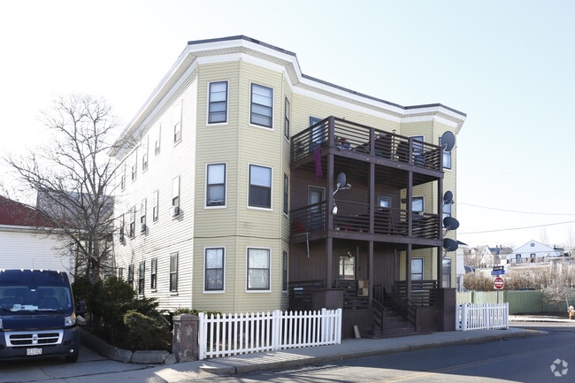
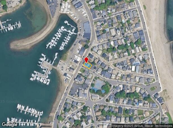
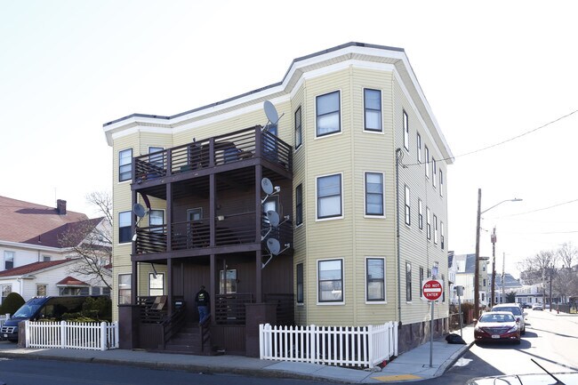
Property Record
566 Shirley St, Winthrop, MA 02152
NEARBY LISTINGS FOR SALE OR LEASE
-
-
No Photo
-
View all Winthrop listings for sale on LoopNet.com
Property Detail
566 Shirley St
WINT-000026-000000-000005
& Beacon St
Apartment
Suffolk
AE
Massachusetts
25025C0101J
5
2025
0.09 AC
2025
Cottage Hill
180500
Boston
5,553 SF
Boston-Cambridge-Newton, MA-NH
DEMOGRAPHICS near 566 Shirley St
1 Mile
3 Mile
5 Mile
2024 Total Population
8,801
40,606
262,892
2029 Population
8,120
37,902
249,845
Pop Growth 2024-2029
(7.74%)
(6.66%)
(4.96%)
Average Age
43
41
38
2024 Total Households
3,677
15,814
110,017
HH Growth 2024-2029
(8.46%)
(7.20%)
(5.06%)
Median Household Inc
$92,256
$73,218
$93,325
Avg Household Size
2.30
2.50
2.30
2024 Avg HH Vehicles
2.00
1.00
1.00
Median Home Value
$629,439
$611,090
$683,287
Median Year Built
1947
1948
1955
Nearby Places
Map Layers
Map Styles
 Street
 Aerial
- Restaurants
- Banks
- Shops
- Fitness
- Groceries
PUBLIC TRANSPORTATION
COMMUTER RAIL
Chelsea (Newburyport/Rockport Line - MBTA)
DRIVE
WALK
Distance
Chelsea (Newburyport/Rockport Line - MBTA)
12 min
6.5 mi
South Station (Fairmount Line - Massachusetts Bay Transportation Authority Commuter Rail (Purple Line), Framingham/Worcester Line - Massachusetts Bay Transportation Authority Commuter Rail (Purple Line), Franklin Line - Massachusetts Bay Transportation Authority Commuter Rail (Purple Line), Greenbush Line - Massachusetts Bay Transportation Authority Commuter Rail (Purple Line), Kingston/Plymouth Line - Massachusetts Bay Transportation Authority Commuter Rail (Purple Line), Middleborough/Lakeville Line - Massachusetts Bay Transportation Authority Commuter Rail (Purple Line), Needham Line - Massachusetts Bay Transportation Authority Commuter Rail (Purple Line), Providence/Stoughton Line - Massachusetts Bay Transportation Authority Commuter Rail (Purple Line))
DRIVE
WALK
Distance
South Station (Fairmount Line - Massachusetts Bay Transportation Authority Commuter Rail (Purple Line), Framingham/Worcester Line - Massachusetts Bay Transportation Authority Commuter Rail (Purple Line), Franklin Line - Massachusetts Bay Transportation Authority Commuter Rail (Purple Line), Greenbush Line - Massachusetts Bay Transportation Authority Commuter Rail (Purple Line), Kingston/Plymouth Line - Massachusetts Bay Transportation Authority Commuter Rail (Purple Line), Middleborough/Lakeville Line - Massachusetts Bay Transportation Authority Commuter Rail (Purple Line), Needham Line - Massachusetts Bay Transportation Authority Commuter Rail (Purple Line), Providence/Stoughton Line - Massachusetts Bay Transportation Authority Commuter Rail (Purple Line))
14 min
7.5 mi
AIRPORT
General Edward Lawrence Logan International
DRIVE
WALK
Distance
General Edward Lawrence Logan International
11 min
5.7 mi
Freight Ports
Port of Boston
DRIVE
WALK
Distance
Port of Boston
17 min
8.4 mi
Nearby Properties
Address
Land Use
TOTAL SIZE
Lot Size
Zoning
Address
Land Use
TOTAL SIZE
Lot Size
Zoning
164,959 SF
96.81 AC
E
Address
Land Use
TOTAL SIZE
Lot Size
Zoning
226,431 SF
4.31 AC
HB
Address
Land Use
TOTAL SIZE
Lot Size
Zoning
154.16 AC
E
Address
Land Use
TOTAL SIZE
Lot Size
Zoning
5,668 SF
20.05 AC
A
Address
Land Use
TOTAL SIZE
Lot Size
Zoning
391,884 SF
108.79 AC
C
Address
Land Use
TOTAL SIZE
Lot Size
Zoning
738 SF
20.71 AC
PORT
Address
Land Use
TOTAL SIZE
Lot Size
Zoning
214,895 SF
3.30 AC
A
Address
Land Use
TOTAL SIZE
Lot Size
Zoning
192,881 SF
6.08 AC
C
Address
Land Use
TOTAL SIZE
Lot Size
Zoning
192,031 SF
8.34 AC
Address
Land Use
TOTAL SIZE
Lot Size
Zoning
130,120 SF
0.83 AC
RC2
Address
Land Use
TOTAL SIZE
Lot Size
Zoning
115,045 SF
6.90 AC
C
Address
Land Use
TOTAL SIZE
Lot Size
Zoning
81.22 AC
E
Address
Land Use
TOTAL SIZE
Lot Size
Zoning
29.47 AC
HB
Address
Land Use
TOTAL SIZE
Lot Size
Zoning
333,370 SF
10.34 AC
C
Address
Land Use
TOTAL SIZE
Lot Size
Zoning
88,200 SF
17.33 AC
C
Address
Land Use
TOTAL SIZE
Lot Size
Zoning
92,853 SF
1.87 AC
E
Address
Land Use
TOTAL SIZE
Lot Size
Zoning
108,216 SF
4.71 AC
RB
Address
Land Use
TOTAL SIZE
Lot Size
Zoning
131,972 SF
5.34 AC
TED
Address
Land Use
TOTAL SIZE
Lot Size
Zoning
84,855 SF
10.25 AC
Address
Land Use
TOTAL SIZE
Lot Size
Zoning
1,134 SF
21.01 AC
TED
Address
Land Use
TOTAL SIZE
Lot Size
Zoning
20.10 AC
TED
Address
Land Use
TOTAL SIZE
Lot Size
Zoning
135,379 SF
15.05 AC
RB
Address
Land Use
TOTAL SIZE
Lot Size
Zoning
63,426 SF
0.74 AC
RC2
Address
Land Use
TOTAL SIZE
Lot Size
Zoning
140,980 SF
5.10 AC
C
Address
Land Use
TOTAL SIZE
Lot Size
Zoning
84,614 SF
1.28 AC
Address
Land Use
TOTAL SIZE
Lot Size
Zoning
4,290 SF
35 AC
PORT
Address
Land Use
TOTAL SIZE
Lot Size
Zoning
121,792 SF
7.75 AC
C
Address
Land Use
TOTAL SIZE
Lot Size
Zoning
68,570 SF
0.84 AC
RC2
Address
Land Use
TOTAL SIZE
Lot Size
Zoning
Address
Land Use
TOTAL SIZE
Lot Size
Zoning
288,792 SF
0.73 AC
EA
The World's #1 Commercial Real Estate Marketplace
Connect with us
© 2025 CoStar Group
The information above has been obtained from sources believed reliable. While we do not doubt its accuracy we have not verified it and make no guarantee, warranty or representation about it. It is your responsibility to independently confirm its accuracy and completeness. Any projections, opinions, assumptions, or estimates used are for example only and do not represent the current or future performance of the property. The value of this transaction to you depends on tax and other factors which should be evaluated by your tax, financial, and legal advisors. You and your advisors should conduct a careful, independent investigation of the property to determine to your satisfaction the suitability of the property for your needs.