Property Record
566 W High St, Aurora, MO 65605

Save to a Folder
{{folder.Name}}
{{folder.ListingIds.length}} Properties
{{folder.ListingIds.length}} Property
Create a New Folder
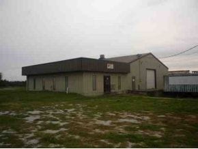
Property Detail
566 W High St
19-1.0-12-000-000-004.000
HIGH,W,566; BEG 621.5'W & 30'S OF NE COR OF NE NW, THEN S530.02' E186.21' N530.07' W202.34' TO BEG L & L - AURORA
Factorymedium
Lawrence
B and X Area of moderate flood hazard, usually the area between the limits of the 100-year and 500-year floods.
Missouri
2025
2.36 AC
2025
Missouri South Area
470601
Other Market Areas
5,000 SF
NEARBY LISTINGS FOR SALE OR LEASE
-
-
View all Aurora listings for sale on LoopNet.com
DEMOGRAPHICS near 566 W High St
1 mile
3 mile
5 mile
2025 Total Population
2,464
9,427
12,965
2030 Population
2,589
9,773
13,420
Pop Growth 2025-2030
+ 5.07%
+ 3.67%
+ 3.51%
Average Age
38
40
41
2025 Total Households
948
3,795
5,172
HH Growth 2025-2030
+ 5.06%
+ 3.66%
+ 3.48%
Median Household Inc
$47,372
$49,894
$54,715
Avg Household Size
2.60
2.50
2.50
2025 Avg HH Vehicles
2.00
2.00
2.00
Median Home Value
$68,364
$125,937
$142,345
Median Year Built
1947
1970
1973
Nearby Places
Map Layers
Map Styles
 Street
 Aerial
Layers
 Traffic
 Biking
Places
Listings with unknown addresses are not visible on the map
- Restaurants
- Banks
- Shops
- Fitness
- Groceries
PUBLIC TRANSPORTATION
AIRPORT
Springfield-Branson Ntl
Drive
Walk
Distance
Springfield-Branson Ntl
58 min
41.9 mi
Freight Ports
Tulsa Port of Inola
Drive
Walk
Distance
Tulsa Port of Inola
170 min
149.5 mi
Nearby Properties
Address
Land Use
TOTAL SIZE
Lot Size
Zoning
Address
Land Use
TOTAL SIZE
Lot Size
Zoning
31,643 SF
51 AC
Address
Land Use
TOTAL SIZE
Lot Size
Zoning
24,928 SF
9.92 AC
Address
Land Use
TOTAL SIZE
Lot Size
Zoning
40,320 SF
1.50 AC
Address
Land Use
TOTAL SIZE
Lot Size
Zoning
151,800 SF
25.85 AC
Address
Land Use
TOTAL SIZE
Lot Size
Zoning
10,170 SF
12.33 AC
Address
Land Use
TOTAL SIZE
Lot Size
Zoning
8,270 SF
1.68 AC
Address
Land Use
TOTAL SIZE
Lot Size
Zoning
46,650 SF
4.69 AC
Address
Land Use
TOTAL SIZE
Lot Size
Zoning
13,913 SF
1.39 AC
Address
Land Use
TOTAL SIZE
Lot Size
Zoning
68,005 SF
7.34 AC
Address
Land Use
TOTAL SIZE
Lot Size
Zoning
11,170 SF
1.38 AC
Address
Land Use
TOTAL SIZE
Lot Size
Zoning
35,113 SF
5.54 AC
Address
Land Use
TOTAL SIZE
Lot Size
Zoning
15,000 SF
10.16 AC
Address
Land Use
TOTAL SIZE
Lot Size
Zoning
43,289 SF
16.46 AC
Address
Land Use
TOTAL SIZE
Lot Size
Zoning
2.76 AC
Address
Land Use
TOTAL SIZE
Lot Size
Zoning
34,010 SF
10 AC
Address
Land Use
TOTAL SIZE
Lot Size
Zoning
7,800 SF
1.96 AC
Address
Land Use
TOTAL SIZE
Lot Size
Zoning
50,960 SF
10 AC
Address
Land Use
TOTAL SIZE
Lot Size
Zoning
9,100 SF
1.88 AC
Address
Land Use
TOTAL SIZE
Lot Size
Zoning
32,000 SF
31.20 AC
Address
Land Use
TOTAL SIZE
Lot Size
Zoning
5,070 SF
4.62 AC
Address
Land Use
TOTAL SIZE
Lot Size
Zoning
2,619 SF
3.75 AC
Address
Land Use
TOTAL SIZE
Lot Size
Zoning
5,971 SF
6 AC
Address
Land Use
TOTAL SIZE
Lot Size
Zoning
3,731 SF
0.64 AC
Address
Land Use
TOTAL SIZE
Lot Size
Zoning
4,080 SF
1.37 AC
Address
Land Use
TOTAL SIZE
Lot Size
Zoning
Address
Land Use
TOTAL SIZE
Lot Size
Zoning
1,064 SF
1.59 AC
The World's #1 Commercial Real Estate Marketplace
Connect with us
© 2026 CoStar Group
The information above has been obtained from sources believed reliable. While we do not doubt its accuracy we have not verified it and make no guarantee, warranty or representation about it. It is your responsibility to independently confirm its accuracy and completeness. Any projections, opinions, assumptions, or estimates used are for example only and do not represent the current or future performance of the property. The value of this transaction to you depends on tax and other factors which should be evaluated by your tax, financial, and legal advisors. You and your advisors should conduct a careful, independent investigation of the property to determine to your satisfaction the suitability of the property for your needs.