Property Record
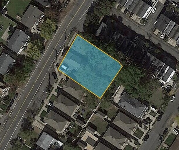
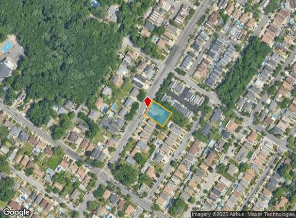
566 Woodrow Rd, Staten Island, NY 10312
NEARBY LISTINGS FOR SALE OR LEASE
Property Detail
566 Woodrow Rd
05717-0032
Map Of Acre Plots At Annadale
Storebuilding
Staten Island
X
New York
3604970316F
32
2024
0.31 AC
2025
Staten Island
017015
Long Island (New York)
1,200 SF
New York-Jersey City-White Plains, NY-NJ
DEMOGRAPHICS near 566 Woodrow Rd
1 Mile
3 Mile
5 Mile
2024 Total Population
36,847
156,870
314,274
2029 Population
36,162
154,067
308,773
Pop Growth 2024-2029
(1.86%)
(1.79%)
(1.75%)
Average Age
42
42
41
2024 Total Households
13,016
56,305
110,398
HH Growth 2024-2029
(2.02%)
(1.85%)
(1.81%)
Median Household Inc
$98,036
$99,772
$94,009
Avg Household Size
2.80
2.70
2.80
2024 Avg HH Vehicles
2.00
2.00
2.00
Median Home Value
$627,648
$659,646
$631,959
Median Year Built
1982
1980
1976
Nearby Places
- Restaurants
- Banks
- Shops
- Fitness
- Groceries
PUBLIC TRANSPORTATION
COMMUTER RAIL
Annadale (Staten Island Railway - New York MTA Subway (The Subway))
DRIVE
WALK
Distance
Annadale (Staten Island Railway - New York MTA Subway (The Subway))
3 min
1.1 mi
Eltingville (Staten Island Railway - New York MTA Subway (The Subway))
DRIVE
WALK
Distance
Eltingville (Staten Island Railway - New York MTA Subway (The Subway))
4 min
1.8 mi
AIRPORT
Newark Liberty International
DRIVE
WALK
Distance
Newark Liberty International
29 min
16.8 mi
LaGuardia
DRIVE
WALK
Distance
LaGuardia
52 min
29.5 mi
John F Kennedy International
DRIVE
WALK
Distance
John F Kennedy International
51 min
32.2 mi
Freight Ports
New York Container Terminal
DRIVE
WALK
Distance
New York Container Terminal
14 min
7.5 mi
Nearby Properties
Address
Land Use
TOTAL SIZE
Lot Size
Zoning
Address
Land Use
TOTAL SIZE
Lot Size
Zoning
3,600 SF
731.18 AC
PARK
Address
Land Use
TOTAL SIZE
Lot Size
Zoning
196.03 AC
HIA
Address
Land Use
TOTAL SIZE
Lot Size
Zoning
794,430 SF
36.09 AC
R50
Address
Land Use
TOTAL SIZE
Lot Size
Zoning
237 AC
M1-1
Address
Land Use
TOTAL SIZE
Lot Size
Zoning
118 AC
M3-1
Address
Land Use
TOTAL SIZE
Lot Size
Zoning
404,985 SF
15.32 AC
R25
Address
Land Use
TOTAL SIZE
Lot Size
Zoning
1,258,042 SF
14.47 AC
C4-1
Address
Land Use
TOTAL SIZE
Lot Size
Zoning
196,382 SF
25.95 AC
Address
Land Use
TOTAL SIZE
Lot Size
Zoning
365,784 SF
12.73 AC
HIA
Address
Land Use
TOTAL SIZE
Lot Size
Zoning
146 AC
PARK
Address
Land Use
TOTAL SIZE
Lot Size
Zoning
286,290 SF
21.24 AC
R50
Address
Land Use
TOTAL SIZE
Lot Size
Zoning
1.64 AC
R-25
Address
Land Use
TOTAL SIZE
Lot Size
Zoning
245,272 SF
18.54 AC
R50
Address
Land Use
TOTAL SIZE
Lot Size
Zoning
263,925 SF
11.98 AC
R50
Address
Land Use
TOTAL SIZE
Lot Size
Zoning
7.24 AC
Address
Land Use
TOTAL SIZE
Lot Size
Zoning
411,000 SF
18.54 AC
R3X
Address
Land Use
TOTAL SIZE
Lot Size
Zoning
55.47 AC
Address
Land Use
TOTAL SIZE
Lot Size
Zoning
21,120 SF
14.45 AC
R50
Address
Land Use
TOTAL SIZE
Lot Size
Zoning
5,214 SF
93 AC
M3-1
Address
Land Use
TOTAL SIZE
Lot Size
Zoning
214,392 SF
11.79 AC
R50
Address
Land Use
TOTAL SIZE
Lot Size
Zoning
Address
Land Use
TOTAL SIZE
Lot Size
Zoning
Address
Land Use
TOTAL SIZE
Lot Size
Zoning
195,395 SF
12.04 AC
R3-2
Address
Land Use
TOTAL SIZE
Lot Size
Zoning
11,140 SF
170.60 AC
PARK
Address
Land Use
TOTAL SIZE
Lot Size
Zoning
220,240 SF
5.77 AC
R3X
Address
Land Use
TOTAL SIZE
Lot Size
Zoning
38.58 AC
PARK
Address
Land Use
TOTAL SIZE
Lot Size
Zoning
134,507 SF
8.47 AC
R50
Address
Land Use
TOTAL SIZE
Lot Size
Zoning
505,000 SF
3.79 AC
R3A
Address
Land Use
TOTAL SIZE
Lot Size
Zoning
75,592 SF
9.86 AC
R50
Address
Land Use
TOTAL SIZE
Lot Size
Zoning
33.36 AC
PARK
The World's #1 Commercial Real Estate Marketplace
Connect with us
© 2025 CoStar Group
The information above has been obtained from sources believed reliable. While we do not doubt its accuracy we have not verified it and make no guarantee, warranty or representation about it. It is your responsibility to independently confirm its accuracy and completeness. Any projections, opinions, assumptions, or estimates used are for example only and do not represent the current or future performance of the property. The value of this transaction to you depends on tax and other factors which should be evaluated by your tax, financial, and legal advisors. You and your advisors should conduct a careful, independent investigation of the property to determine to your satisfaction the suitability of the property for your needs.