Property Record
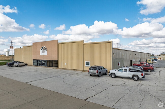
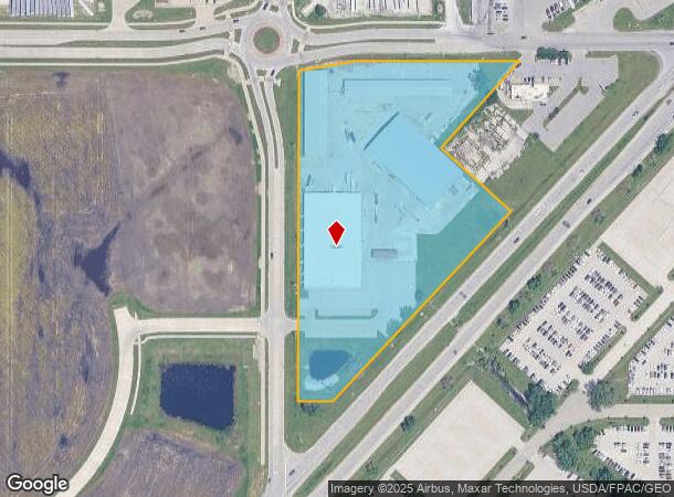
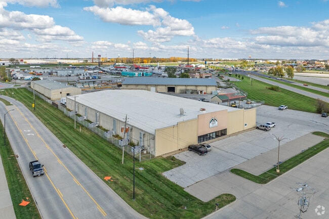
5660 Ne Hubbell Ave, Altoona, IA 50009
NEARBY LISTINGS FOR SALE OR LEASE
Property Detail
5660 Ne Hubbell Ave
171/00118-004-003
Sec 14-79-23
Storebuilding
-EX BEG W 1/4 COR SEC 14 THN N 1534.24F NE 210.66F W 93.95F N 871.16F TO POB THN N 27.76F E 151.26F SW 153.8F TO POB- & -EX IREG PC BEG 923.3F E & 33F S NW COR THN S 84.2F SWLY 455F NWLY 255F NE 328.6F E 275F- NW 1/4 NW 1/4 N & W OF HWY 65 SEC 14-79-
X
Polk
19153C0220F
Iowa
2024
8.11 AC
2025
Northeast
010707
Des Moines
75,250 SF
Des Moines-West Des Moines, IA
DEMOGRAPHICS near 5660 Ne Hubbell Ave
1 Mile
3 Mile
5 Mile
2024 Total Population
1,101
31,428
71,093
2029 Population
1,142
32,951
74,384
Pop Growth 2024-2029
+ 3.72%
+ 4.85%
+ 4.63%
Average Age
38
38
38
2024 Total Households
420
12,279
27,165
HH Growth 2024-2029
+ 3.81%
+ 4.93%
+ 4.66%
Median Household Inc
$73,706
$75,679
$75,421
Avg Household Size
2.50
2.50
2.60
2024 Avg HH Vehicles
2.00
2.00
2.00
Median Home Value
$185,293
$227,069
$213,313
Median Year Built
1985
1995
1988
Nearby Places
Map Layers
Map Styles
 Street
 Aerial
- Restaurants
- Banks
- Shops
- Fitness
- Groceries
PUBLIC TRANSPORTATION
AIRPORT
Des Moines International
DRIVE
WALK
Distance
Des Moines International
28 min
14.0 mi
Freight Ports
Port Milwaukee
DRIVE
WALK
Distance
Port Milwaukee
403 min
364.2 mi
Nearby Properties
Address
Land Use
TOTAL SIZE
Lot Size
Zoning
Address
Land Use
TOTAL SIZE
Lot Size
Zoning
1,232,488 SF
184.19 AC
Address
Land Use
TOTAL SIZE
Lot Size
Zoning
1,089,208 SF
145.90 AC
Address
Land Use
TOTAL SIZE
Lot Size
Zoning
1,018,608 SF
190.56 AC
Address
Land Use
TOTAL SIZE
Lot Size
Zoning
2,693,534 SF
167.13 AC
Address
Land Use
TOTAL SIZE
Lot Size
Zoning
549,615 SF
149.20 AC
C6
Address
Land Use
TOTAL SIZE
Lot Size
Zoning
497,587 SF
31.46 AC
Address
Land Use
TOTAL SIZE
Lot Size
Zoning
459,000 SF
19.69 AC
Address
Land Use
TOTAL SIZE
Lot Size
Zoning
350,879 SF
16.14 AC
Address
Land Use
TOTAL SIZE
Lot Size
Zoning
397,563 SF
18.25 AC
Address
Land Use
TOTAL SIZE
Lot Size
Zoning
333,079 SF
34.07 AC
Address
Land Use
TOTAL SIZE
Lot Size
Zoning
146,138 SF
22.78 AC
C-3
Address
Land Use
TOTAL SIZE
Lot Size
Zoning
327,600 SF
16.57 AC
Address
Land Use
TOTAL SIZE
Lot Size
Zoning
212,388 SF
40.63 AC
Address
Land Use
TOTAL SIZE
Lot Size
Zoning
325,160 SF
17.24 AC
Address
Land Use
TOTAL SIZE
Lot Size
Zoning
359,441 SF
173.80 AC
C6
Address
Land Use
TOTAL SIZE
Lot Size
Zoning
259,056 SF
16.31 AC
Address
Land Use
TOTAL SIZE
Lot Size
Zoning
302,604 SF
16.46 AC
Address
Land Use
TOTAL SIZE
Lot Size
Zoning
265,726 SF
14.76 AC
Address
Land Use
TOTAL SIZE
Lot Size
Zoning
300,000 SF
18.95 AC
Address
Land Use
TOTAL SIZE
Lot Size
Zoning
300,000 SF
20.09 AC
Address
Land Use
TOTAL SIZE
Lot Size
Zoning
320,429 SF
22.34 AC
R3
Address
Land Use
TOTAL SIZE
Lot Size
Zoning
270,000 SF
18.35 AC
Address
Land Use
TOTAL SIZE
Lot Size
Zoning
270,000 SF
14.55 AC
Address
Land Use
TOTAL SIZE
Lot Size
Zoning
142,032 SF
10 AC
Address
Land Use
TOTAL SIZE
Lot Size
Zoning
195,500 SF
15.03 AC
Address
Land Use
TOTAL SIZE
Lot Size
Zoning
195,500 SF
8.09 AC
Address
Land Use
TOTAL SIZE
Lot Size
Zoning
167,308 SF
16.46 AC
Address
Land Use
TOTAL SIZE
Lot Size
Zoning
205,728 SF
21.74 AC
Address
Land Use
TOTAL SIZE
Lot Size
Zoning
78,180 SF
7.31 AC
Address
Land Use
TOTAL SIZE
Lot Size
Zoning
135,824 SF
13.22 AC
The World's #1 Commercial Real Estate Marketplace
Connect with us
© 2025 CoStar Group
The information above has been obtained from sources believed reliable. While we do not doubt its accuracy we have not verified it and make no guarantee, warranty or representation about it. It is your responsibility to independently confirm its accuracy and completeness. Any projections, opinions, assumptions, or estimates used are for example only and do not represent the current or future performance of the property. The value of this transaction to you depends on tax and other factors which should be evaluated by your tax, financial, and legal advisors. You and your advisors should conduct a careful, independent investigation of the property to determine to your satisfaction the suitability of the property for your needs.