Property Record
5664 Mud Mill Rd, Brewerton, NY 13029

NEARBY LISTINGS FOR SALE OR LEASE
Property Detail
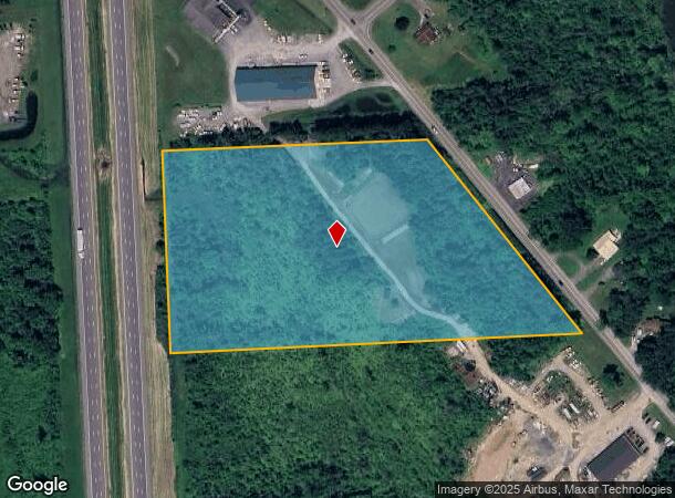
5664 Mud Mill Rd
Syracuse, NY
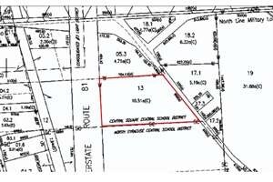
FL 20 1171631
312289-108-000-0001-013-000-0000
Onondaga
Residentialacreage
New York
X
13.000
36067C0084F
10.51 AC
2025
NE Outer Onondaga County
2024
Syracuse
010200
DEMOGRAPHICS near 5664 Mud Mill Rd
1 Mile
3 Mile
5 Mile
2024 Total Population
1,421
12,881
37,142
2029 Population
1,380
12,531
36,174
Pop Growth 2024-2029
(2.89%)
(2.72%)
(2.61%)
Average Age
41
42
42
2024 Total Households
567
5,132
14,830
HH Growth 2024-2029
(3.17%)
(2.96%)
(2.81%)
Median Household Inc
$70,995
$98,399
$95,199
Avg Household Size
2.40
2.50
2.50
2024 Avg HH Vehicles
2.00
2.00
2.00
Median Home Value
$215,563
$194,577
$192,677
Median Year Built
1984
1983
1980
Nearby Places
- Restaurants
- Banks
- Shops
- Fitness
- Groceries
PUBLIC TRANSPORTATION
AIRPORT
Syracuse Hancock International
DRIVE
WALK
Distance
Syracuse Hancock International
16 min
10.0 mi
Freight Ports
Albany, NY Port
DRIVE
WALK
Distance
Albany, NY Port
180 min
150.4 mi
SALE & LEASE HISTORY
LISTING DATE
SALE/LEASE

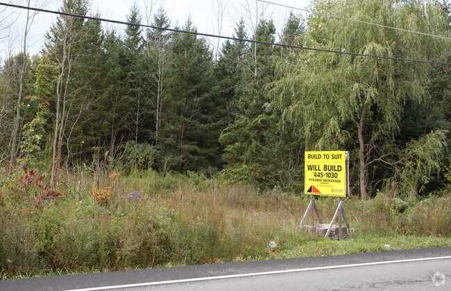
Sep 26, 2016
For Lease
Nearby Properties
Address
Land Use
TOTAL SIZE
Lot Size
Zoning
Address
Land Use
TOTAL SIZE
Lot Size
Zoning
8,417 SF
13.95 AC
Address
Land Use
TOTAL SIZE
Lot Size
Zoning
1,568 SF
330.36 AC
Address
Land Use
TOTAL SIZE
Lot Size
Zoning
66,538 SF
18.24 AC
Address
Land Use
TOTAL SIZE
Lot Size
Zoning
57,052 SF
16.82 AC
Address
Land Use
TOTAL SIZE
Lot Size
Zoning
39,128 SF
17.22 AC
Address
Land Use
TOTAL SIZE
Lot Size
Zoning
271,263 SF
77.30 AC
Address
Land Use
TOTAL SIZE
Lot Size
Zoning
17,436 SF
98.89 AC
06000
Address
Land Use
TOTAL SIZE
Lot Size
Zoning
16,630 SF
10.16 AC
Address
Land Use
TOTAL SIZE
Lot Size
Zoning
900 SF
0.44 AC
R-10
Address
Land Use
TOTAL SIZE
Lot Size
Zoning
43,968 SF
1.95 AC
Address
Land Use
TOTAL SIZE
Lot Size
Zoning
660 SF
9.75 AC
WH
Address
Land Use
TOTAL SIZE
Lot Size
Zoning
3,724 SF
56.89 AC
N00
Address
Land Use
TOTAL SIZE
Lot Size
Zoning
12,220 SF
5.86 AC
Address
Land Use
TOTAL SIZE
Lot Size
Zoning
51,587 SF
10.37 AC
Address
Land Use
TOTAL SIZE
Lot Size
Zoning
7,416 SF
7.30 AC
Address
Land Use
TOTAL SIZE
Lot Size
Zoning
74,342 SF
8.81 AC
Address
Land Use
TOTAL SIZE
Lot Size
Zoning
26,724 SF
89.15 AC
Address
Land Use
TOTAL SIZE
Lot Size
Zoning
116,020 SF
15.72 AC
PUD
Address
Land Use
TOTAL SIZE
Lot Size
Zoning
39,591 SF
7.39 AC
Address
Land Use
TOTAL SIZE
Lot Size
Zoning
42,720 SF
3.09 AC
Address
Land Use
TOTAL SIZE
Lot Size
Zoning
12,978 SF
3.71 AC
PUD-R
Address
Land Use
TOTAL SIZE
Lot Size
Zoning
56,215 SF
7.31 AC
Address
Land Use
TOTAL SIZE
Lot Size
Zoning
11.96 AC
Address
Land Use
TOTAL SIZE
Lot Size
Zoning
42,210 SF
62.23 AC
N00
Address
Land Use
TOTAL SIZE
Lot Size
Zoning
26,445 SF
3.95 AC
Address
Land Use
TOTAL SIZE
Lot Size
Zoning
952 SF
3.81 AC
Address
Land Use
TOTAL SIZE
Lot Size
Zoning
16,630 SF
2.66 AC
Address
Land Use
TOTAL SIZE
Lot Size
Zoning
16,630 SF
3.95 AC
Address
Land Use
TOTAL SIZE
Lot Size
Zoning
7,500 SF
21.82 AC
CI
Address
Land Use
TOTAL SIZE
Lot Size
Zoning
39,055 SF
28.38 AC
The World's #1 Commercial Real Estate Marketplace
Connect with us
© 2025 CoStar Group
The information above has been obtained from sources believed reliable. While we do not doubt its accuracy we have not verified it and make no guarantee, warranty or representation about it. It is your responsibility to independently confirm its accuracy and completeness. Any projections, opinions, assumptions, or estimates used are for example only and do not represent the current or future performance of the property. The value of this transaction to you depends on tax and other factors which should be evaluated by your tax, financial, and legal advisors. You and your advisors should conduct a careful, independent investigation of the property to determine to your satisfaction the suitability of the property for your needs.