Property Record
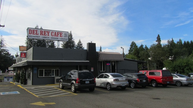
5669 Ne Stephens St, Winchester, OR 97495

Property Detail
5669 Ne Stephens St
R11948
WINCHESTER VACATED M&B, BLOCK PT 29 & ADJ VAC ST, ACRES 0.40
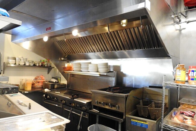
Commercialnec
Douglas
C2
Oregon
B and X Area of moderate flood hazard, usually the area between the limits of the 100-year and 500-year floods.
0.40 AC
2025
Oregon West Area
2025
Other Market Areas
090001
Roseburg, OR
3,018 SF
NEARBY LISTINGS FOR SALE OR LEASE
DEMOGRAPHICS near 5669 Ne Stephens St
1 mile
3 mile
5 mile
2025 Total Population
2,807
9,839
30,037
2030 Population
2,810
9,840
30,274
Pop Growth 2025-2030
+ 0.11%
+ 0.01%
+ 0.79%
Average Age
46
47
45
2025 Total Households
1,218
4,304
12,704
HH Growth 2025-2030
(0.25%)
(0.02%)
+ 0.82%
Median Household Inc
$66,362
$62,371
$60,988
Avg Household Size
2.20
2.20
2.20
2025 Avg HH Vehicles
2.00
2.00
2.00
Median Home Value
$388,181
$363,636
$345,172
Median Year Built
1984
1982
1977
Nearby Places
Map Layers
Map Styles
 Street
 Aerial
Layers
 Traffic
 Biking
Places
Listings with unknown addresses are not visible on the map
- Restaurants
- Banks
- Shops
- Fitness
- Groceries
SALE & LEASE HISTORY
LISTING DATE
SALE/LEASE

Jan 06, 2021
For Sale
Feb 20, 2019
For Sale
Nearby Properties
Address
Land Use
TOTAL SIZE
Lot Size
Zoning
Address
Land Use
TOTAL SIZE
Lot Size
Zoning
276,720 SF
18.77 AC
PR
Address
Land Use
TOTAL SIZE
Lot Size
Zoning
32,749 SF
97.09 AC
PR
Address
Land Use
TOTAL SIZE
Lot Size
Zoning
102.28 AC
AP
Address
Land Use
TOTAL SIZE
Lot Size
Zoning
138,337 SF
16.25 AC
MU
Address
Land Use
TOTAL SIZE
Lot Size
Zoning
4.39 AC
PR
Address
Land Use
TOTAL SIZE
Lot Size
Zoning
71,302 SF
1.84 AC
PR
Address
Land Use
TOTAL SIZE
Lot Size
Zoning
32.37 AC
M3
Address
Land Use
TOTAL SIZE
Lot Size
Zoning
124,320 SF
13.02 AC
MR40
Address
Land Use
TOTAL SIZE
Lot Size
Zoning
103,469 SF
10.45 AC
MU
Address
Land Use
TOTAL SIZE
Lot Size
Zoning
42,708 SF
0.78 AC
PR
Address
Land Use
TOTAL SIZE
Lot Size
Zoning
68,135 SF
8.13 AC
C3
Address
Land Use
TOTAL SIZE
Lot Size
Zoning
37,755 SF
2.80 AC
C3
Address
Land Use
TOTAL SIZE
Lot Size
Zoning
57,685 SF
5.34 AC
C3
Address
Land Use
TOTAL SIZE
Lot Size
Zoning
21,852 SF
2.70 AC
C3
Address
Land Use
TOTAL SIZE
Lot Size
Zoning
23,996 SF
2.23 AC
C3
Address
Land Use
TOTAL SIZE
Lot Size
Zoning
70,897 SF
4.32 AC
C3
Address
Land Use
TOTAL SIZE
Lot Size
Zoning
1.99 AC
PR
Address
Land Use
TOTAL SIZE
Lot Size
Zoning
18,094 SF
2.48 AC
C3
Address
Land Use
TOTAL SIZE
Lot Size
Zoning
109,704 SF
3.17 AC
M2
Address
Land Use
TOTAL SIZE
Lot Size
Zoning
29,161 SF
3.43 AC
C3
Address
Land Use
TOTAL SIZE
Lot Size
Zoning
5.18 AC
M2
Address
Land Use
TOTAL SIZE
Lot Size
Zoning
14.82 AC
AP
Address
Land Use
TOTAL SIZE
Lot Size
Zoning
3,000 SF
40.80 AC
AP
Address
Land Use
TOTAL SIZE
Lot Size
Zoning
38,186 SF
4.10 AC
C3
Address
Land Use
TOTAL SIZE
Lot Size
Zoning
52,140 SF
6 AC
M3
Address
Land Use
TOTAL SIZE
Lot Size
Zoning
4.63 AC
M2
Address
Land Use
TOTAL SIZE
Lot Size
Zoning
12,589 SF
0.95 AC
C3
Address
Land Use
TOTAL SIZE
Lot Size
Zoning
88 SF
1.95 AC
MU
Address
Land Use
TOTAL SIZE
Lot Size
Zoning
108 SF
1.51 AC
C3
Address
Land Use
TOTAL SIZE
Lot Size
Zoning
30,860 SF
4.65 AC
MU
The World's #1 Commercial Real Estate Marketplace
Connect with us
© 2026 CoStar Group
The information above has been obtained from sources believed reliable. While we do not doubt its accuracy we have not verified it and make no guarantee, warranty or representation about it. It is your responsibility to independently confirm its accuracy and completeness. Any projections, opinions, assumptions, or estimates used are for example only and do not represent the current or future performance of the property. The value of this transaction to you depends on tax and other factors which should be evaluated by your tax, financial, and legal advisors. You and your advisors should conduct a careful, independent investigation of the property to determine to your satisfaction the suitability of the property for your needs.