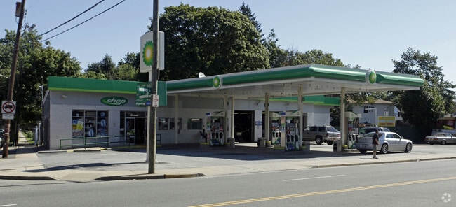
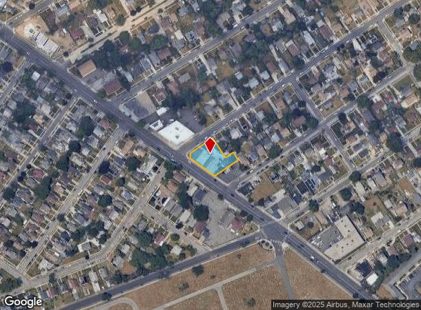
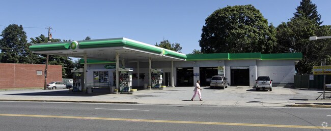
Property Record
567 Greenwich St, Hempstead, NY 11550
NEARBY LISTINGS FOR SALE OR LEASE
Property Detail
567 Greenwich St
Nassau County-Suffolk County, NY
Robinwood
2013-36-116-00-0147-A
147A & 147B
Servicestationmarket
Nassau
X
New York
36059C0228G
147
2025
0.38 AC
2025
Central Nassau
407102
Long Island (New York)
21,310 SF
DEMOGRAPHICS near 567 Greenwich St
1 Mile
3 Mile
5 Mile
2024 Total Population
38,037
231,646
590,276
2029 Population
37,305
227,487
578,700
Pop Growth 2024-2029
(1.92%)
(1.80%)
(1.96%)
Average Age
39
39
41
2024 Total Households
9,470
66,032
186,608
HH Growth 2024-2029
(1.99%)
(1.84%)
(2.03%)
Median Household Inc
$94,510
$112,067
$121,556
Avg Household Size
3.60
3.20
3.00
2024 Avg HH Vehicles
2.00
2.00
2.00
Median Home Value
$410,654
$537,525
$619,064
Median Year Built
1951
1952
1953
Nearby Places
- Restaurants
- Banks
- Shops
- Fitness
- Groceries
PUBLIC TRANSPORTATION
COMMUTER RAIL
Hempstead Station (Hempstead Branch - Long Island Rail Road)
DRIVE
WALK
Distance
Hempstead Station (Hempstead Branch - Long Island Rail Road)
4 min
1.8 mi
West Hempstead Station (West Hempstead Branch - Long Island Rail Road)
DRIVE
WALK
Distance
West Hempstead Station (West Hempstead Branch - Long Island Rail Road)
5 min
2.4 mi
AIRPORT
John F Kennedy International
DRIVE
WALK
Distance
John F Kennedy International
22 min
13.7 mi
LaGuardia
DRIVE
WALK
Distance
LaGuardia
32 min
18.1 mi
Westchester County
DRIVE
WALK
Distance
Westchester County
60 min
39.5 mi
Freight Ports
NY - Red Hook Container Terminal
DRIVE
WALK
Distance
NY - Red Hook Container Terminal
43 min
26.2 mi
Nearby Properties
Address
Land Use
TOTAL SIZE
Lot Size
Zoning
Address
Land Use
TOTAL SIZE
Lot Size
Zoning
5,322,666 SF
86.10 AC
Address
Land Use
TOTAL SIZE
Lot Size
Zoning
419,282 SF
57.46 AC
Address
Land Use
TOTAL SIZE
Lot Size
Zoning
202.54 AC
Address
Land Use
TOTAL SIZE
Lot Size
Zoning
1,188,742 SF
11.93 AC
Address
Land Use
TOTAL SIZE
Lot Size
Zoning
181,472 SF
168.80 AC
Address
Land Use
TOTAL SIZE
Lot Size
Zoning
1,197,283 SF
64.50 AC
Address
Land Use
TOTAL SIZE
Lot Size
Zoning
574,353 SF
65 AC
Address
Land Use
TOTAL SIZE
Lot Size
Zoning
2,835 SF
239 AC
Address
Land Use
TOTAL SIZE
Lot Size
Zoning
186 AC
Address
Land Use
TOTAL SIZE
Lot Size
Zoning
51,432 SF
32.03 AC
Address
Land Use
TOTAL SIZE
Lot Size
Zoning
822,113 SF
26 AC
Address
Land Use
TOTAL SIZE
Lot Size
Zoning
962,971 SF
18.90 AC
Address
Land Use
TOTAL SIZE
Lot Size
Zoning
341,098 SF
31.88 AC
Address
Land Use
TOTAL SIZE
Lot Size
Zoning
5,628 SF
31.86 AC
Address
Land Use
TOTAL SIZE
Lot Size
Zoning
130,720 SF
48.60 AC
Address
Land Use
TOTAL SIZE
Lot Size
Zoning
111,756 SF
21.24 AC
Address
Land Use
TOTAL SIZE
Lot Size
Zoning
94,204 SF
35.42 AC
Address
Land Use
TOTAL SIZE
Lot Size
Zoning
92,466 SF
8 AC
Address
Land Use
TOTAL SIZE
Lot Size
Zoning
145,209 SF
20.01 AC
Address
Land Use
TOTAL SIZE
Lot Size
Zoning
254,845 SF
22.28 AC
Address
Land Use
TOTAL SIZE
Lot Size
Zoning
29,998 SF
22.49 AC
Address
Land Use
TOTAL SIZE
Lot Size
Zoning
76.10 AC
Address
Land Use
TOTAL SIZE
Lot Size
Zoning
83.42 AC
Address
Land Use
TOTAL SIZE
Lot Size
Zoning
115.42 AC
Address
Land Use
TOTAL SIZE
Lot Size
Zoning
126,558 SF
12.76 AC
Address
Land Use
TOTAL SIZE
Lot Size
Zoning
441,888 SF
22.09 AC
Address
Land Use
TOTAL SIZE
Lot Size
Zoning
225,460 SF
14.70 AC
Address
Land Use
TOTAL SIZE
Lot Size
Zoning
293,443 SF
21.86 AC
Address
Land Use
TOTAL SIZE
Lot Size
Zoning
377,041 SF
14.43 AC
Address
Land Use
TOTAL SIZE
Lot Size
Zoning
17,292 SF
60.83 AC
The World's #1 Commercial Real Estate Marketplace
Connect with us
© 2025 CoStar Group
The information above has been obtained from sources believed reliable. While we do not doubt its accuracy we have not verified it and make no guarantee, warranty or representation about it. It is your responsibility to independently confirm its accuracy and completeness. Any projections, opinions, assumptions, or estimates used are for example only and do not represent the current or future performance of the property. The value of this transaction to you depends on tax and other factors which should be evaluated by your tax, financial, and legal advisors. You and your advisors should conduct a careful, independent investigation of the property to determine to your satisfaction the suitability of the property for your needs.