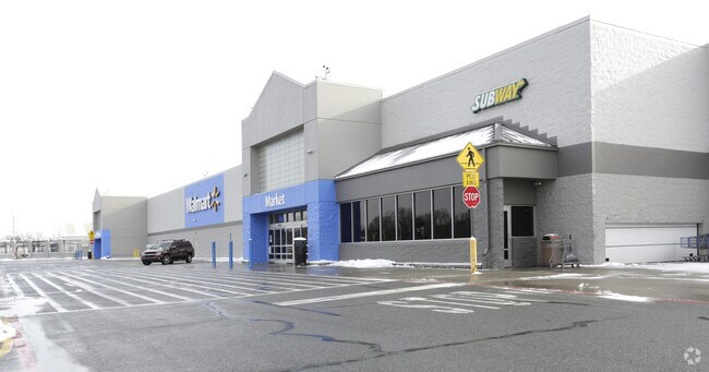
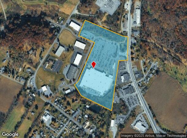
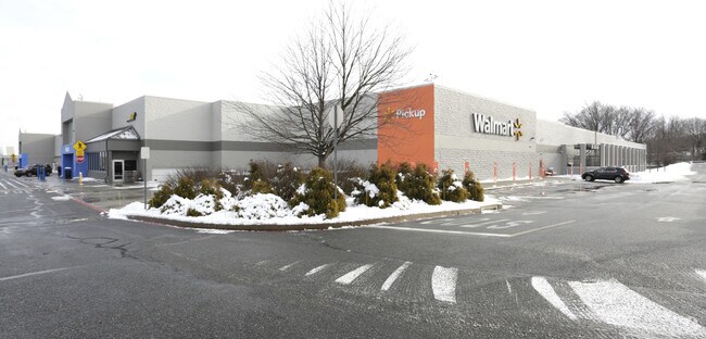
Property Record
567 N Route 100, Bechtelsville, PA 19505
NEARBY LISTINGS FOR SALE OR LEASE
Property Detail
567 N Route 100
38-5397-05-08-5068
Hotspur
Regionalshoppingcenterormallwithanchorstore
Berks
A
Pennsylvania
42011C0557G
2
2025
24.21 AC
2025
Berks County
013100
Philadelphia
188,596 SF
Reading, PA
DEMOGRAPHICS near 567 N Route 100
1 Mile
3 Mile
5 Mile
2024 Total Population
1,551
20,554
40,838
2029 Population
1,534
20,658
41,101
Pop Growth 2024-2029
(1.10%)
+ 0.51%
+ 0.64%
Average Age
43
43
42
2024 Total Households
618
8,248
15,609
HH Growth 2024-2029
(1.13%)
+ 0.45%
+ 0.57%
Median Household Inc
$77,917
$80,444
$89,505
Avg Household Size
2.50
2.50
2.60
2024 Avg HH Vehicles
2.00
2.00
2.00
Median Home Value
$216,964
$253,973
$278,264
Median Year Built
1959
1970
1974
Nearby Places
Map Layers
Map Styles
 Street
 Aerial
- Restaurants
- Banks
- Shops
- Fitness
- Groceries
PUBLIC TRANSPORTATION
AIRPORT
Lehigh Valley International
DRIVE
WALK
Distance
Lehigh Valley International
50 min
26.8 mi
Freight Ports
Port of Philadelphia
DRIVE
WALK
Distance
Port of Philadelphia
73 min
43.2 mi
Nearby Properties
Address
Land Use
TOTAL SIZE
Lot Size
Zoning
Address
Land Use
TOTAL SIZE
Lot Size
Zoning
5.98 AC
M1
Address
Land Use
TOTAL SIZE
Lot Size
Zoning
89,618 SF
11.02 AC
M1
Address
Land Use
TOTAL SIZE
Lot Size
Zoning
71,093 SF
2.64 AC
Address
Land Use
TOTAL SIZE
Lot Size
Zoning
88,494 SF
27.29 AC
IN
Address
Land Use
TOTAL SIZE
Lot Size
Zoning
199,496 SF
20.55 AC
M1
Address
Land Use
TOTAL SIZE
Lot Size
Zoning
47,136 SF
2.49 AC
Address
Land Use
TOTAL SIZE
Lot Size
Zoning
90,925 SF
9.33 AC
GC
Address
Land Use
TOTAL SIZE
Lot Size
Zoning
42,336 SF
4.28 AC
R4
Address
Land Use
TOTAL SIZE
Lot Size
Zoning
83,400 SF
11.34 AC
GC
Address
Land Use
TOTAL SIZE
Lot Size
Zoning
224,550 SF
21.20 AC
Address
Land Use
TOTAL SIZE
Lot Size
Zoning
113,341 SF
11.03 AC
Address
Land Use
TOTAL SIZE
Lot Size
Zoning
48,320 SF
5 AC
GC
Address
Land Use
TOTAL SIZE
Lot Size
Zoning
40,751 SF
12.78 AC
IN
Address
Land Use
TOTAL SIZE
Lot Size
Zoning
65,162 SF
9.05 AC
GC
Address
Land Use
TOTAL SIZE
Lot Size
Zoning
44,060 SF
24.54 AC
Address
Land Use
TOTAL SIZE
Lot Size
Zoning
78,000 SF
9.44 AC
M1
Address
Land Use
TOTAL SIZE
Lot Size
Zoning
236,153 SF
30.47 AC
M2
Address
Land Use
TOTAL SIZE
Lot Size
Zoning
20,460 SF
3.50 AC
R4
Address
Land Use
TOTAL SIZE
Lot Size
Zoning
264,545 SF
17.18 AC
Address
Land Use
TOTAL SIZE
Lot Size
Zoning
161,138 SF
160.99 AC
Address
Land Use
TOTAL SIZE
Lot Size
Zoning
73,397 SF
4.36 AC
M1
Address
Land Use
TOTAL SIZE
Lot Size
Zoning
19,632 SF
4.31 AC
IN
Address
Land Use
TOTAL SIZE
Lot Size
Zoning
27,733 SF
2 AC
IN
Address
Land Use
TOTAL SIZE
Lot Size
Zoning
15,296 SF
6.96 AC
IN
Address
Land Use
TOTAL SIZE
Lot Size
Zoning
18,920 SF
6.17 AC
GC
Address
Land Use
TOTAL SIZE
Lot Size
Zoning
20,388 SF
2.70 AC
Address
Land Use
TOTAL SIZE
Lot Size
Zoning
23,118 SF
2.09 AC
R4
Address
Land Use
TOTAL SIZE
Lot Size
Zoning
32,160 SF
7.05 AC
Address
Land Use
TOTAL SIZE
Lot Size
Zoning
26,906 SF
4.41 AC
M1
The World's #1 Commercial Real Estate Marketplace
Connect with us
© 2026 CoStar Group
The information above has been obtained from sources believed reliable. While we do not doubt its accuracy we have not verified it and make no guarantee, warranty or representation about it. It is your responsibility to independently confirm its accuracy and completeness. Any projections, opinions, assumptions, or estimates used are for example only and do not represent the current or future performance of the property. The value of this transaction to you depends on tax and other factors which should be evaluated by your tax, financial, and legal advisors. You and your advisors should conduct a careful, independent investigation of the property to determine to your satisfaction the suitability of the property for your needs.