Property Record
567 Old Hopewell Rd, Hopewell Junction, NY 12533
NEARBY LISTINGS FOR SALE OR LEASE
Property Detail
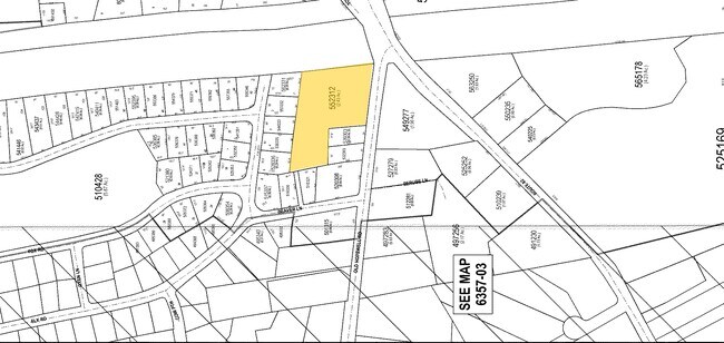
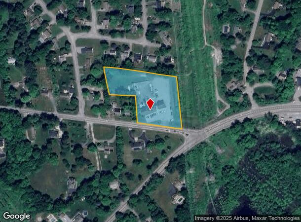
567 Old Hopewell Rd
132800-6357-04-552312-0000
2.545 AC 1989 0246 1450 0214
Commercialnec
Dutchess
X
New York
36027C0479E
552
2025
2.54 AC
2024
Fishkill
050102
Westchester/So Connecticut
4,920 SF
Dutchess County-Putnam County, NY
DEMOGRAPHICS near 567 Old Hopewell Rd
1 Mile
3 Mile
5 Mile
2024 Total Population
2,699
25,680
62,316
2029 Population
2,676
25,573
62,150
Pop Growth 2024-2029
(0.85%)
(0.42%)
(0.27%)
Average Age
42
43
43
2024 Total Households
937
9,194
23,399
HH Growth 2024-2029
(0.96%)
(0.42%)
(0.26%)
Median Household Inc
$106,839
$110,811
$102,803
Avg Household Size
2.80
2.70
2.60
2024 Avg HH Vehicles
2.00
2.00
2.00
Median Home Value
$349,356
$378,184
$382,000
Median Year Built
1967
1974
1974
Nearby Places
- Restaurants
- Banks
- Shops
- Fitness
- Groceries
PUBLIC TRANSPORTATION
COMMUTER RAIL
New Hamburg Station (Hudson Line - Metro-North Commuter Railroad Company (Metro-North))
DRIVE
WALK
Distance
New Hamburg Station (Hudson Line - Metro-North Commuter Railroad Company (Metro-North))
15 min
6.2 mi
AIRPORT
New York Stewart International
DRIVE
WALK
Distance
New York Stewart International
31 min
18.5 mi
Freight Ports
Port of New Haven
DRIVE
WALK
Distance
Port of New Haven
95 min
67.0 mi
Nearby Properties
Address
Land Use
TOTAL SIZE
Lot Size
Zoning
Address
Land Use
TOTAL SIZE
Lot Size
Zoning
98.94 AC
I1
Address
Land Use
TOTAL SIZE
Lot Size
Zoning
633,840 SF
93.64 AC
I1
Address
Land Use
TOTAL SIZE
Lot Size
Zoning
45.64 AC
I1
Address
Land Use
TOTAL SIZE
Lot Size
Zoning
800 SF
10.21 AC
R1
Address
Land Use
TOTAL SIZE
Lot Size
Zoning
73,316 SF
30 AC
R1
Address
Land Use
TOTAL SIZE
Lot Size
Zoning
120,294 SF
29.50 AC
B3
Address
Land Use
TOTAL SIZE
Lot Size
Zoning
Address
Land Use
TOTAL SIZE
Lot Size
Zoning
4,212 SF
13.84 AC
HC
Address
Land Use
TOTAL SIZE
Lot Size
Zoning
104,800 SF
17.20 AC
R20
Address
Land Use
TOTAL SIZE
Lot Size
Zoning
203,657 SF
36.08 AC
R1
Address
Land Use
TOTAL SIZE
Lot Size
Zoning
151,698 SF
22.50 AC
PI
Address
Land Use
TOTAL SIZE
Lot Size
Zoning
40,553 SF
17.96 AC
R1
Address
Land Use
TOTAL SIZE
Lot Size
Zoning
54,595 SF
11 AC
R15
Address
Land Use
TOTAL SIZE
Lot Size
Zoning
56,824 SF
10 AC
RMF5
Address
Land Use
TOTAL SIZE
Lot Size
Zoning
12,550 SF
1.85 AC
R1
Address
Land Use
TOTAL SIZE
Lot Size
Zoning
25.03 AC
Address
Land Use
TOTAL SIZE
Lot Size
Zoning
68,660 SF
9.54 AC
B2
Address
Land Use
TOTAL SIZE
Lot Size
Zoning
11.55 AC
R1
Address
Land Use
TOTAL SIZE
Lot Size
Zoning
Address
Land Use
TOTAL SIZE
Lot Size
Zoning
Address
Land Use
TOTAL SIZE
Lot Size
Zoning
52,731 SF
3.97 AC
B2
Address
Land Use
TOTAL SIZE
Lot Size
Zoning
29.42 AC
I1
Address
Land Use
TOTAL SIZE
Lot Size
Zoning
19,738 SF
14.20 AC
R40
Address
Land Use
TOTAL SIZE
Lot Size
Zoning
Address
Land Use
TOTAL SIZE
Lot Size
Zoning
1.50 AC
B1
Address
Land Use
TOTAL SIZE
Lot Size
Zoning
Address
Land Use
TOTAL SIZE
Lot Size
Zoning
43,800 SF
5.77 AC
RB
Address
Land Use
TOTAL SIZE
Lot Size
Zoning
33,180 SF
4.72 AC
B3
Address
Land Use
TOTAL SIZE
Lot Size
Zoning
59,814 SF
9.04 AC
PB
Address
Land Use
TOTAL SIZE
Lot Size
Zoning
The World's #1 Commercial Real Estate Marketplace
Connect with us
© 2025 CoStar Group
The information above has been obtained from sources believed reliable. While we do not doubt its accuracy we have not verified it and make no guarantee, warranty or representation about it. It is your responsibility to independently confirm its accuracy and completeness. Any projections, opinions, assumptions, or estimates used are for example only and do not represent the current or future performance of the property. The value of this transaction to you depends on tax and other factors which should be evaluated by your tax, financial, and legal advisors. You and your advisors should conduct a careful, independent investigation of the property to determine to your satisfaction the suitability of the property for your needs.