Property Record
5670 Old Winder Hwy, Braselton, GA 30517
NEARBY LISTINGS FOR SALE OR LEASE
Property Detail
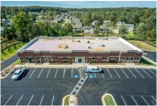
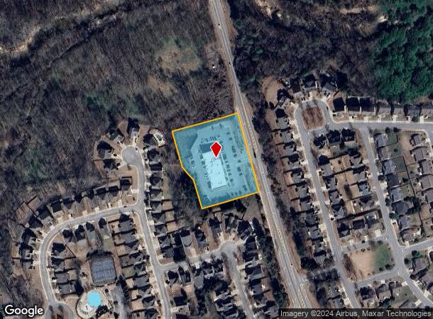
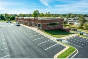
5670 Old Winder Hwy
15-00039-00-070
Old Winder Hwy Commercial
Medicalbuilding
OLD WINDER HIGHWAY
X
Hall
13013C0025D
Georgia
2025
2.57 AC
2025
Gainesville/Hall County
001612
Atlanta
24,800 SF
Gainesville, GA
DEMOGRAPHICS near 5670 Old Winder Hwy
1 Mile
3 Mile
5 Mile
2024 Total Population
4,261
24,444
69,817
2029 Population
4,643
27,893
78,890
Pop Growth 2024-2029
+ 8.97%
+ 14.11%
+ 13.00%
Average Age
43
41
39
2024 Total Households
1,593
8,544
23,441
HH Growth 2024-2029
+ 9.10%
+ 13.52%
+ 12.90%
Median Household Inc
$94,208
$109,040
$99,653
Avg Household Size
2.70
2.80
3.00
2024 Avg HH Vehicles
2.00
2.00
2.00
Median Home Value
$374,737
$361,846
$340,228
Median Year Built
2006
2007
2004
Nearby Places
Map Layers
Map Styles
 Street
 Aerial
- Restaurants
- Banks
- Shops
- Fitness
- Groceries
SALE & LEASE HISTORY
LISTING DATE
SALE/LEASE

Nov 10, 2017
For Lease
May 11, 2021
For Lease
Jan 14, 2022
For Lease
Dec 05, 2023
For Lease
Dec 02, 2019
For Lease
Nearby Properties
Address
Land Use
TOTAL SIZE
Lot Size
Zoning
Address
Land Use
TOTAL SIZE
Lot Size
Zoning
105,000 SF
104.18 AC
POD
Address
Land Use
TOTAL SIZE
Lot Size
Zoning
30,720 SF
12.28 AC
G-C
Address
Land Use
TOTAL SIZE
Lot Size
Zoning
381,371 SF
77.27 AC
PUD
Address
Land Use
TOTAL SIZE
Lot Size
Zoning
160,277 SF
53.35 AC
PUD
Address
Land Use
TOTAL SIZE
Lot Size
Zoning
521,290 SF
23.64 AC
MD
Address
Land Use
TOTAL SIZE
Lot Size
Zoning
510,720 SF
48.46 AC
M1
Address
Land Use
TOTAL SIZE
Lot Size
Zoning
263,400 SF
8.65 AC
PRD
Address
Land Use
TOTAL SIZE
Lot Size
Zoning
114,835 SF
15.29 AC
POD
Address
Land Use
TOTAL SIZE
Lot Size
Zoning
422,920 SF
24.67 AC
MD
Address
Land Use
TOTAL SIZE
Lot Size
Zoning
46,400 SF
3.51 AC
G-C
Address
Land Use
TOTAL SIZE
Lot Size
Zoning
110,886 SF
34.34 AC
POD
Address
Land Use
TOTAL SIZE
Lot Size
Zoning
547,250 SF
47.51 AC
M1
Address
Land Use
TOTAL SIZE
Lot Size
Zoning
9,800 SF
681.58 AC
PCD
Address
Land Use
TOTAL SIZE
Lot Size
Zoning
44,824 SF
3.22 AC
G-C
Address
Land Use
TOTAL SIZE
Lot Size
Zoning
42,053 SF
40.85 AC
PUD
Address
Land Use
TOTAL SIZE
Lot Size
Zoning
24,486 SF
3.85 AC
G-C
Address
Land Use
TOTAL SIZE
Lot Size
Zoning
18,510 SF
490.78 AC
PRD/PCD
Address
Land Use
TOTAL SIZE
Lot Size
Zoning
5,220 SF
53.11 AC
PUD
Address
Land Use
TOTAL SIZE
Lot Size
Zoning
82,604 SF
13.11 AC
G-C
Address
Land Use
TOTAL SIZE
Lot Size
Zoning
71,951 SF
8.78 AC
PRD
Address
Land Use
TOTAL SIZE
Lot Size
Zoning
240,946 SF
21.51 AC
004
Address
Land Use
TOTAL SIZE
Lot Size
Zoning
1,280 SF
24.21 AC
PCD
Address
Land Use
TOTAL SIZE
Lot Size
Zoning
73,810 SF
34.67 AC
GC
Address
Land Use
TOTAL SIZE
Lot Size
Zoning
42,848 SF
4.55 AC
G-C
Address
Land Use
TOTAL SIZE
Lot Size
Zoning
76,566 SF
10.33 AC
PUD
Address
Land Use
TOTAL SIZE
Lot Size
Zoning
15,000 SF
7.53 AC
G-C
Address
Land Use
TOTAL SIZE
Lot Size
Zoning
24,290 SF
6.15 AC
PUD
Address
Land Use
TOTAL SIZE
Lot Size
Zoning
35,318 SF
6.72 AC
G-C
Address
Land Use
TOTAL SIZE
Lot Size
Zoning
8,204 SF
5.25 AC
G-C
Address
Land Use
TOTAL SIZE
Lot Size
Zoning
191.82 AC
PUD
The World's #1 Commercial Real Estate Marketplace
Connect with us
© 2026 CoStar Group
The information above has been obtained from sources believed reliable. While we do not doubt its accuracy we have not verified it and make no guarantee, warranty or representation about it. It is your responsibility to independently confirm its accuracy and completeness. Any projections, opinions, assumptions, or estimates used are for example only and do not represent the current or future performance of the property. The value of this transaction to you depends on tax and other factors which should be evaluated by your tax, financial, and legal advisors. You and your advisors should conduct a careful, independent investigation of the property to determine to your satisfaction the suitability of the property for your needs.