Property Record
5675 E Ann Rd, Las Vegas, NV 89115
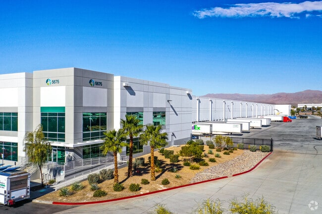

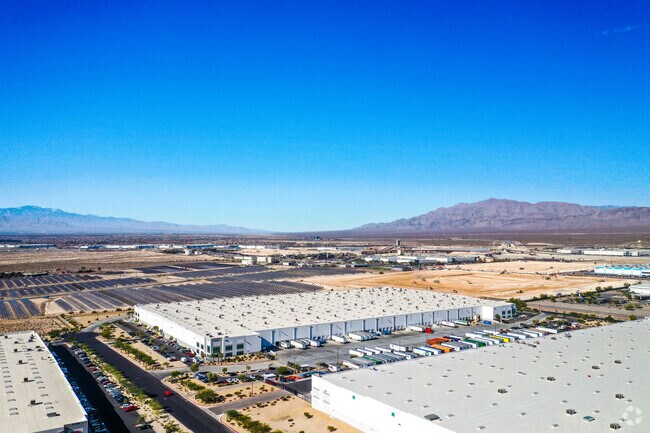
Property Detail
5675 E Ann Rd
Las Vegas-Henderson-North Las Vegas, NV
PARCEL MAP FILE 121 PAGE 94 LOT 1A
123-33-501-005
Clark
Shipyard
Nevada
2026
1a
2026
32.27 AC
003649
North Las Vegas
621,824 SF
Las Vegas
NEARBY LISTINGS FOR SALE OR LEASE
DEMOGRAPHICS near 5675 E Ann Rd
1 mile
3 mile
5 mile
2025 Total Population
1,625
46,860
160,333
2030 Population
1,689
49,124
168,929
Pop Growth 2025-2030
+ 3.94%
+ 4.83%
+ 5.36%
Average Age
29
34
34
2025 Total Households
270
14,840
49,831
HH Growth 2025-2030
+ 3.33%
+ 4.81%
+ 5.42%
Median Household Inc
$71,712
$63,667
$65,363
Avg Household Size
3.60
3.00
3.10
2025 Avg HH Vehicles
1.00
2.00
2.00
Median Home Value
$158,333
$361,567
$357,233
Median Year Built
2010
2000
1999
Nearby Places
Map Layers
Map Styles
 Street
 Aerial
Layers
 Traffic
 Biking
Places
Listings with unknown addresses are not visible on the map
- Restaurants
- Banks
- Shops
- Fitness
- Groceries
PUBLIC TRANSPORTATION
AIRPORT
Harry Reid International
Drive
Walk
Distance
Harry Reid International
29 min
18.3 mi
Boulder City Municipal
Drive
Walk
Distance
Boulder City Municipal
48 min
31.0 mi
SALE & LEASE HISTORY
LISTING DATE
SALE/LEASE

Sep 25, 2016
For Lease
Sep 03, 2020
For Lease
May 15, 2019
For Lease
Feb 21, 2023
For Lease
Apr 24, 2020
For Lease
Nearby Properties
Address
Land Use
TOTAL SIZE
Lot Size
Zoning
Address
Land Use
TOTAL SIZE
Lot Size
Zoning
1,350,116 SF
69.82 AC
C2
Address
Land Use
TOTAL SIZE
Lot Size
Zoning
237,606 SF
324.73 AC
C2
Address
Land Use
TOTAL SIZE
Lot Size
Zoning
168,609 SF
279.17 AC
RU
Address
Land Use
TOTAL SIZE
Lot Size
Zoning
935,120 SF
41.04 AC
Address
Land Use
TOTAL SIZE
Lot Size
Zoning
688,360 SF
63.10 AC
M1
Address
Land Use
TOTAL SIZE
Lot Size
Zoning
49,394 SF
390.30 AC
C2
Address
Land Use
TOTAL SIZE
Lot Size
Zoning
1,102,891 SF
84.40 AC
Address
Land Use
TOTAL SIZE
Lot Size
Zoning
798,660 SF
37.86 AC
M2
Address
Land Use
TOTAL SIZE
Lot Size
Zoning
813,120 SF
38.20 AC
Address
Land Use
TOTAL SIZE
Lot Size
Zoning
656,250 SF
29.11 AC
Address
Land Use
TOTAL SIZE
Lot Size
Zoning
588,286 SF
33.26 AC
Address
Land Use
TOTAL SIZE
Lot Size
Zoning
747,196 SF
40.03 AC
Address
Land Use
TOTAL SIZE
Lot Size
Zoning
632,224 SF
31.23 AC
Address
Land Use
TOTAL SIZE
Lot Size
Zoning
681,792 SF
29.65 AC
Address
Land Use
TOTAL SIZE
Lot Size
Zoning
677,768 SF
31.52 AC
Address
Land Use
TOTAL SIZE
Lot Size
Zoning
869,320 SF
58.75 AC
M1
Address
Land Use
TOTAL SIZE
Lot Size
Zoning
15,566 SF
48.39 AC
R4
Address
Land Use
TOTAL SIZE
Lot Size
Zoning
570,810 SF
29.73 AC
Address
Land Use
TOTAL SIZE
Lot Size
Zoning
720,000 SF
25.07 AC
Address
Land Use
TOTAL SIZE
Lot Size
Zoning
625,804 SF
27.23 AC
Address
Land Use
TOTAL SIZE
Lot Size
Zoning
10,579 SF
252.71 AC
C2
The World's #1 Commercial Real Estate Marketplace
Connect with us
© 2026 CoStar Group
The information above has been obtained from sources believed reliable. While we do not doubt its accuracy we have not verified it and make no guarantee, warranty or representation about it. It is your responsibility to independently confirm its accuracy and completeness. Any projections, opinions, assumptions, or estimates used are for example only and do not represent the current or future performance of the property. The value of this transaction to you depends on tax and other factors which should be evaluated by your tax, financial, and legal advisors. You and your advisors should conduct a careful, independent investigation of the property to determine to your satisfaction the suitability of the property for your needs.