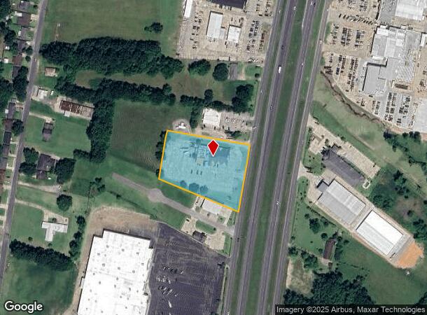
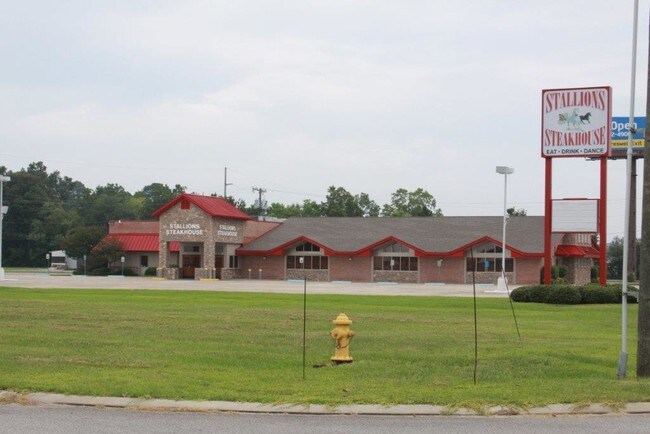
Property Record
5675 I 49 S Service Rd, Opelousas, LA 70570

NEARBY LISTINGS FOR SALE OR LEASE
Property Detail
5675 I 49 S Service Rd
Opelousas, LA
I-49 Serv Rd S 1-0P
0102821500
1 LOT (2.119 AC) PART OF TRACTS 5 & 6 OF MOUTON PLAT N ROY MOTORS TRACT 5 S JOHN VALLIEN TRACT 7 E I-49 SERVICE ROAD W ROY MO
Commercialnec
St Landry
X
Louisiana
22097C0315D
1,38-41
2024
2.12 AC
2024
Lafayette
961502
Other Market Areas
DEMOGRAPHICS near 5675 I 49 S Service Rd
1 Mile
3 Mile
5 Mile
2024 Total Population
4,079
22,998
31,569
2029 Population
4,037
22,969
31,384
Pop Growth 2024-2029
(1.03%)
(0.13%)
(0.59%)
Average Age
39
38
38
2024 Total Households
1,731
9,037
12,312
HH Growth 2024-2029
(0.92%)
(0.10%)
(0.54%)
Median Household Inc
$33,933
$33,934
$39,512
Avg Household Size
2.30
2.40
2.40
2024 Avg HH Vehicles
1.00
1.00
2.00
Median Home Value
$176,585
$136,243
$151,173
Median Year Built
1971
1972
1974
Nearby Places
Map Layers
Map Styles
 Street
 Aerial
- Restaurants
- Banks
- Shops
- Fitness
- Groceries
PUBLIC TRANSPORTATION
AIRPORT
Lafayette Regional/Paul Fournet Field
DRIVE
WALK
Distance
Lafayette Regional/Paul Fournet Field
30 min
22.9 mi
Freight Ports
Port of Iberia
DRIVE
WALK
Distance
Port of Iberia
56 min
44.2 mi
SALE & LEASE HISTORY
LISTING DATE
SALE/LEASE

Sep 25, 2016
For Lease
Sep 24, 2016
For Sale
Apr 06, 2017
For Lease
Apr 06, 2017
For Sale
Nearby Properties
Address
Land Use
TOTAL SIZE
Lot Size
Zoning
Address
Land Use
TOTAL SIZE
Lot Size
Zoning
Address
Land Use
TOTAL SIZE
Lot Size
Zoning
Address
Land Use
TOTAL SIZE
Lot Size
Zoning
Address
Land Use
TOTAL SIZE
Lot Size
Zoning
Address
Land Use
TOTAL SIZE
Lot Size
Zoning
Address
Land Use
TOTAL SIZE
Lot Size
Zoning
Address
Land Use
TOTAL SIZE
Lot Size
Zoning
Address
Land Use
TOTAL SIZE
Lot Size
Zoning
Address
Land Use
TOTAL SIZE
Lot Size
Zoning
Address
Land Use
TOTAL SIZE
Lot Size
Zoning
Address
Land Use
TOTAL SIZE
Lot Size
Zoning
6.26 AC
Address
Land Use
TOTAL SIZE
Lot Size
Zoning
Address
Land Use
TOTAL SIZE
Lot Size
Zoning
Address
Land Use
TOTAL SIZE
Lot Size
Zoning
Address
Land Use
TOTAL SIZE
Lot Size
Zoning
Address
Land Use
TOTAL SIZE
Lot Size
Zoning
Address
Land Use
TOTAL SIZE
Lot Size
Zoning
Address
Land Use
TOTAL SIZE
Lot Size
Zoning
Address
Land Use
TOTAL SIZE
Lot Size
Zoning
Address
Land Use
TOTAL SIZE
Lot Size
Zoning
Address
Land Use
TOTAL SIZE
Lot Size
Zoning
Address
Land Use
TOTAL SIZE
Lot Size
Zoning
Address
Land Use
TOTAL SIZE
Lot Size
Zoning
Address
Land Use
TOTAL SIZE
Lot Size
Zoning
Address
Land Use
TOTAL SIZE
Lot Size
Zoning
Address
Land Use
TOTAL SIZE
Lot Size
Zoning
5.84 AC
Address
Land Use
TOTAL SIZE
Lot Size
Zoning
1.06 AC
Address
Land Use
TOTAL SIZE
Lot Size
Zoning
Address
Land Use
TOTAL SIZE
Lot Size
Zoning
Address
Land Use
TOTAL SIZE
Lot Size
Zoning
The World's #1 Commercial Real Estate Marketplace
Connect with us
© 2026 CoStar Group
The information above has been obtained from sources believed reliable. While we do not doubt its accuracy we have not verified it and make no guarantee, warranty or representation about it. It is your responsibility to independently confirm its accuracy and completeness. Any projections, opinions, assumptions, or estimates used are for example only and do not represent the current or future performance of the property. The value of this transaction to you depends on tax and other factors which should be evaluated by your tax, financial, and legal advisors. You and your advisors should conduct a careful, independent investigation of the property to determine to your satisfaction the suitability of the property for your needs.