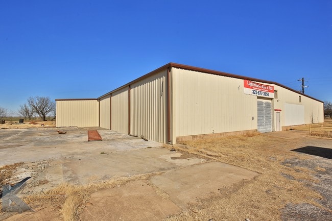
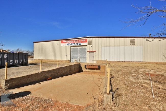
Property Record
5680 E Interstate 20, Abilene, TX 79601

Property Detail
5680 E Interstate 20
Abilene, TX
ACRES: 1.390 ABST 1411 SEC 43 J GILLILAND (BOAT SALES)
R000008603
CALLAHAN
Commercialnec
Texas
2025
1.39 AC
2025
Texas North Area
030102
Other Market Areas
18,240 SF
NEARBY LISTINGS FOR SALE OR LEASE
DEMOGRAPHICS near 5680 E Interstate 20
1 mile
3 mile
5 mile
2025 Total Population
249
600
13,178
2030 Population
261
628
13,662
Pop Growth 2025-2030
+ 4.82%
+ 4.67%
+ 3.67%
Average Age
40
40
39
2025 Total Households
93
229
5,415
HH Growth 2025-2030
+ 4.30%
+ 4.80%
+ 3.71%
Median Household Inc
$77,083
$77,557
$65,448
Avg Household Size
2.40
2.50
2.20
2025 Avg HH Vehicles
2.00
2.00
2.00
Median Home Value
$231,818
$236,250
$238,143
Median Year Built
1992
1995
1987
Nearby Places
Map Layers
Map Styles
 Street
 Aerial
Transit
 Traffic
 Biking
Places
Listings with unknown addresses are not visible on the map
- Restaurants
- Banks
- Shops
- Fitness
- Groceries
PUBLIC TRANSPORTATION
AIRPORT
Abilene Regional
Drive
Walk
Distance
Abilene Regional
12 min
6.1 mi
Freight Ports
Calhoun Port
Drive
Walk
Distance
Calhoun Port
443 min
379.4 mi
SALE & LEASE HISTORY
LISTING DATE
SALE/LEASE

Dec 18, 2018
For Sale
Nearby Properties
Address
Land Use
TOTAL SIZE
Lot Size
Zoning
Address
Land Use
TOTAL SIZE
Lot Size
Zoning
234,447 SF
19.56 AC
Address
Land Use
TOTAL SIZE
Lot Size
Zoning
114,674 SF
39.90 AC
Address
Land Use
TOTAL SIZE
Lot Size
Zoning
160,523 SF
37.09 AC
Address
Land Use
TOTAL SIZE
Lot Size
Zoning
13,090 SF
7.58 AC
Address
Land Use
TOTAL SIZE
Lot Size
Zoning
62,220 SF
18.29 AC
Address
Land Use
TOTAL SIZE
Lot Size
Zoning
106,100 SF
12.39 AC
Address
Land Use
TOTAL SIZE
Lot Size
Zoning
28,480 SF
3.95 AC
Address
Land Use
TOTAL SIZE
Lot Size
Zoning
21,180 SF
21.30 AC
Address
Land Use
TOTAL SIZE
Lot Size
Zoning
5 AC
Address
Land Use
TOTAL SIZE
Lot Size
Zoning
79,068 SF
35.98 AC
Address
Land Use
TOTAL SIZE
Lot Size
Zoning
72,379 SF
5.55 AC
Address
Land Use
TOTAL SIZE
Lot Size
Zoning
10.28 AC
Address
Land Use
TOTAL SIZE
Lot Size
Zoning
7,824 SF
12.82 AC
Address
Land Use
TOTAL SIZE
Lot Size
Zoning
9,600 SF
3.62 AC
Address
Land Use
TOTAL SIZE
Lot Size
Zoning
656 SF
35.92 AC
Address
Land Use
TOTAL SIZE
Lot Size
Zoning
24,204 SF
2.69 AC
Address
Land Use
TOTAL SIZE
Lot Size
Zoning
23,210 SF
7.86 AC
Address
Land Use
TOTAL SIZE
Lot Size
Zoning
40,640 SF
7.78 AC
Address
Land Use
TOTAL SIZE
Lot Size
Zoning
22,642 SF
4.92 AC
Address
Land Use
TOTAL SIZE
Lot Size
Zoning
16,975 SF
3 AC
Address
Land Use
TOTAL SIZE
Lot Size
Zoning
15,000 SF
2.45 AC
Address
Land Use
TOTAL SIZE
Lot Size
Zoning
17,650 SF
4.11 AC
Address
Land Use
TOTAL SIZE
Lot Size
Zoning
15,108 SF
4.81 AC
Address
Land Use
TOTAL SIZE
Lot Size
Zoning
5,000 SF
11.57 AC
Address
Land Use
TOTAL SIZE
Lot Size
Zoning
18,600 SF
5 AC
Address
Land Use
TOTAL SIZE
Lot Size
Zoning
7,850 SF
2.64 AC
Address
Land Use
TOTAL SIZE
Lot Size
Zoning
40,322 SF
7.60 AC
Address
Land Use
TOTAL SIZE
Lot Size
Zoning
10,296 SF
2.12 AC
Address
Land Use
TOTAL SIZE
Lot Size
Zoning
16,784 SF
9.16 AC
Address
Land Use
TOTAL SIZE
Lot Size
Zoning
6,102 SF
66.94 AC
The World's #1 Commercial Real Estate Marketplace
Connect with us
© 2026 CoStar Group
The information above has been obtained from sources believed reliable. While we do not doubt its accuracy we have not verified it and make no guarantee, warranty or representation about it. It is your responsibility to independently confirm its accuracy and completeness. Any projections, opinions, assumptions, or estimates used are for example only and do not represent the current or future performance of the property. The value of this transaction to you depends on tax and other factors which should be evaluated by your tax, financial, and legal advisors. You and your advisors should conduct a careful, independent investigation of the property to determine to your satisfaction the suitability of the property for your needs.