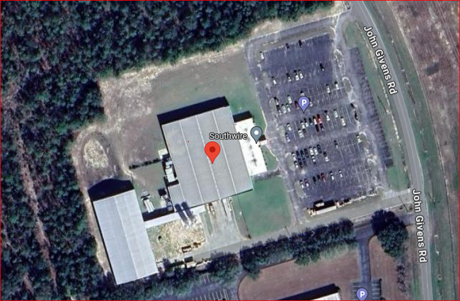
Property Record
5680 John Givens Rd, Crestview, FL 32539

Property Detail
5680 John Givens Rd
Crestview-Fort Walton Beach-Destin, FL
COM SE COR E165.12 FT TO CTR LINE OF GIVENS RD N4 DEG W1878.25 FT TO BEG OF CURVE ALG CURVE 39.20 FT THC S73 DEG W50.85 FT TO POB S73 DEG W806.26 FT N16 DEG W500 FT N73 DEG E800 FT TO PT ON W R/W LINE OF GIVENS RD ALG R/W SE504.84 FT TO POB AS OR
03-3N-23-0000-0001-0040
OKALOOSA
Lightindustrial
Florida
B and X Area of moderate flood hazard, usually the area between the limits of the 100-year and 500-year floods.
40
2025
9.41 AC
2025
Fort Walton Beach
020400
Other Market Areas
65,645 SF
NEARBY LISTINGS FOR SALE OR LEASE
-
-
View all Crestview listings for sale on LoopNet.com
DEMOGRAPHICS near 5680 John Givens Rd
1 mile
3 mile
5 mile
2025 Total Population
1,109
17,817
40,994
2030 Population
1,121
18,336
42,454
Pop Growth 2025-2030
+ 1.08%
+ 2.91%
+ 3.56%
Average Age
42
39
38
2025 Total Households
424
6,383
14,793
HH Growth 2025-2030
+ 0.94%
+ 2.80%
+ 3.42%
Median Household Inc
$105,926
$78,854
$78,885
Avg Household Size
2.50
2.60
2.60
2025 Avg HH Vehicles
2.00
2.00
2.00
Median Home Value
$295,768
$297,716
$308,531
Median Year Built
1993
1993
1997
Nearby Places
Map Layers
Map Styles
 Street
 Aerial
Layers
 Traffic
 Biking
Places
Listings with unknown addresses are not visible on the map
- Restaurants
- Banks
- Shops
- Fitness
- Groceries
PUBLIC TRANSPORTATION
AIRPORT
Eglin AFB/Destin-Ft Walton Beach
Drive
Walk
Distance
Eglin AFB/Destin-Ft Walton Beach
58 min
30.2 mi
SALE & LEASE HISTORY
LISTING DATE
SALE/LEASE

Mar 14, 2024
For Sale
Nearby Properties
Address
Land Use
TOTAL SIZE
Lot Size
Zoning
Address
Land Use
TOTAL SIZE
Lot Size
Zoning
368,602 SF
29.05 AC
Address
Land Use
TOTAL SIZE
Lot Size
Zoning
309,767 SF
328.77 AC
Address
Land Use
TOTAL SIZE
Lot Size
Zoning
13,976 SF
19.04 AC
C-1
Address
Land Use
TOTAL SIZE
Lot Size
Zoning
297,438 SF
39.75 AC
Address
Land Use
TOTAL SIZE
Lot Size
Zoning
150,810 SF
22.68 AC
Address
Land Use
TOTAL SIZE
Lot Size
Zoning
346,810 SF
26 AC
Address
Land Use
TOTAL SIZE
Lot Size
Zoning
80,274 SF
12.60 AC
Address
Land Use
TOTAL SIZE
Lot Size
Zoning
193,986 SF
65 AC
Address
Land Use
TOTAL SIZE
Lot Size
Zoning
128,128 SF
30.01 AC
Address
Land Use
TOTAL SIZE
Lot Size
Zoning
62,274 SF
7 AC
Address
Land Use
TOTAL SIZE
Lot Size
Zoning
40,754 SF
23.67 AC
Address
Land Use
TOTAL SIZE
Lot Size
Zoning
210,809 SF
2.06 AC
Address
Land Use
TOTAL SIZE
Lot Size
Zoning
88,248 SF
5.17 AC
Address
Land Use
TOTAL SIZE
Lot Size
Zoning
102,916 SF
18.06 AC
Address
Land Use
TOTAL SIZE
Lot Size
Zoning
70,068 SF
4.10 AC
Address
Land Use
TOTAL SIZE
Lot Size
Zoning
42,405 SF
14.59 AC
Address
Land Use
TOTAL SIZE
Lot Size
Zoning
25,933 SF
1.12 AC
Address
Land Use
TOTAL SIZE
Lot Size
Zoning
60,807 SF
3.59 AC
Address
Land Use
TOTAL SIZE
Lot Size
Zoning
48,750 SF
2.41 AC
Address
Land Use
TOTAL SIZE
Lot Size
Zoning
92,380 SF
11.99 AC
Address
Land Use
TOTAL SIZE
Lot Size
Zoning
10,160 SF
41.85 AC
Address
Land Use
TOTAL SIZE
Lot Size
Zoning
25,399 SF
6.21 AC
Address
Land Use
TOTAL SIZE
Lot Size
Zoning
16.68 AC
Address
Land Use
TOTAL SIZE
Lot Size
Zoning
24,890 SF
18.40 AC
Address
Land Use
TOTAL SIZE
Lot Size
Zoning
52,974 SF
0.98 AC
Address
Land Use
TOTAL SIZE
Lot Size
Zoning
43,776 SF
7.43 AC
Address
Land Use
TOTAL SIZE
Lot Size
Zoning
30,541 SF
3.52 AC
Address
Land Use
TOTAL SIZE
Lot Size
Zoning
Address
Land Use
TOTAL SIZE
Lot Size
Zoning
31,105 SF
12.02 AC
The World's #1 Commercial Real Estate Marketplace
Connect with us
© 2026 CoStar Group
The information above has been obtained from sources believed reliable. While we do not doubt its accuracy we have not verified it and make no guarantee, warranty or representation about it. It is your responsibility to independently confirm its accuracy and completeness. Any projections, opinions, assumptions, or estimates used are for example only and do not represent the current or future performance of the property. The value of this transaction to you depends on tax and other factors which should be evaluated by your tax, financial, and legal advisors. You and your advisors should conduct a careful, independent investigation of the property to determine to your satisfaction the suitability of the property for your needs.