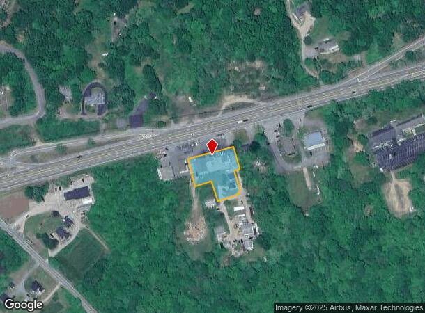
Property Record
5680 Post Rd, Charlestown, RI 02813

NEARBY LISTINGS FOR SALE OR LEASE
-
-
View all Charlestown listings for lease on LoopNet.com
Property Detail
5680 Post Rd
CHAR-000004-000000-000067
Washington
Commercialofficeresidentialmixeduse
Rhode Island
X
67
44009C0277K
0.73 AC
2025
Washington County
2025
Providence
051101
Providence-Warwick, RI-MA
DEMOGRAPHICS near 5680 Post Rd
1 Mile
3 Mile
5 Mile
2024 Total Population
1,025
5,013
13,437
2029 Population
1,112
5,240
13,892
Pop Growth 2024-2029
+ 8.49%
+ 4.53%
+ 3.39%
Average Age
54
50
49
2024 Total Households
506
2,250
5,941
HH Growth 2024-2029
+ 8.89%
+ 4.98%
+ 3.70%
Median Household Inc
$94,059
$104,397
$96,506
Avg Household Size
2.00
2.20
2.20
2024 Avg HH Vehicles
2.00
2.00
2.00
Median Home Value
$671,296
$519,349
$467,149
Median Year Built
1973
1978
1978
Nearby Places
Map Layers
Map Styles
 Street
 Aerial
- Restaurants
- Banks
- Shops
- Fitness
- Groceries
PUBLIC TRANSPORTATION
COMMUTER RAIL
Westerly Amtrak Station (Northeast Regional - Amtrak)
DRIVE
WALK
Distance
Westerly Amtrak Station (Northeast Regional - Amtrak)
12 min
8.1 mi
AIRPORT
Rhode Island Tf Green International
DRIVE
WALK
Distance
Rhode Island Tf Green International
54 min
39.3 mi
Freight Ports
Port of Davisville, RI
DRIVE
WALK
Distance
Port of Davisville, RI
45 min
29.1 mi
SALE & LEASE HISTORY
LISTING DATE
SALE/LEASE

May 19, 2022
For Lease
Dec 13, 2016
For Sale
Apr 18, 2022
For Lease
Nearby Properties
Address
Land Use
TOTAL SIZE
Lot Size
Zoning
Address
Land Use
TOTAL SIZE
Lot Size
Zoning
290.30 AC
Address
Land Use
TOTAL SIZE
Lot Size
Zoning
43,251 SF
Address
Land Use
TOTAL SIZE
Lot Size
Zoning
6.54 AC
GI
Address
Land Use
TOTAL SIZE
Lot Size
Zoning
2.78 AC
R2A
Address
Land Use
TOTAL SIZE
Lot Size
Zoning
2.12 AC
R2A
Address
Land Use
TOTAL SIZE
Lot Size
Zoning
847 AC
OSR
Address
Land Use
TOTAL SIZE
Lot Size
Zoning
31,018 SF
4.05 AC
Address
Land Use
TOTAL SIZE
Lot Size
Zoning
10.61 AC
Address
Land Use
TOTAL SIZE
Lot Size
Zoning
175 AC
M
Address
Land Use
TOTAL SIZE
Lot Size
Zoning
379.71 AC
OSR
Address
Land Use
TOTAL SIZE
Lot Size
Zoning
0.89 AC
Address
Land Use
TOTAL SIZE
Lot Size
Zoning
1.27 AC
Address
Land Use
TOTAL SIZE
Lot Size
Zoning
806 SF
3.49 AC
R2A
Address
Land Use
TOTAL SIZE
Lot Size
Zoning
9,967 SF
9.48 AC
M
Address
Land Use
TOTAL SIZE
Lot Size
Zoning
5.14 AC
R3A
Address
Land Use
TOTAL SIZE
Lot Size
Zoning
32,137 SF
4.17 AC
Address
Land Use
TOTAL SIZE
Lot Size
Zoning
Address
Land Use
TOTAL SIZE
Lot Size
Zoning
2.14 AC
R2A
Address
Land Use
TOTAL SIZE
Lot Size
Zoning
0.90 AC
Address
Land Use
TOTAL SIZE
Lot Size
Zoning
2,711 SF
0.77 AC
R2A
Address
Land Use
TOTAL SIZE
Lot Size
Zoning
10.02 AC
R3A
Address
Land Use
TOTAL SIZE
Lot Size
Zoning
1.10 AC
Address
Land Use
TOTAL SIZE
Lot Size
Zoning
3.41 AC
Address
Land Use
TOTAL SIZE
Lot Size
Zoning
0.28 AC
R2A
Address
Land Use
TOTAL SIZE
Lot Size
Zoning
1.02 AC
R2A
Address
Land Use
TOTAL SIZE
Lot Size
Zoning
2,211 SF
0.55 AC
Address
Land Use
TOTAL SIZE
Lot Size
Zoning
0.68 AC
R2A
Address
Land Use
TOTAL SIZE
Lot Size
Zoning
77.90 AC
R2A
Address
Land Use
TOTAL SIZE
Lot Size
Zoning
0.41 AC
R2A
Address
Land Use
TOTAL SIZE
Lot Size
Zoning
14.47 AC
The World's #1 Commercial Real Estate Marketplace
Connect with us
© 2026 CoStar Group
The information above has been obtained from sources believed reliable. While we do not doubt its accuracy we have not verified it and make no guarantee, warranty or representation about it. It is your responsibility to independently confirm its accuracy and completeness. Any projections, opinions, assumptions, or estimates used are for example only and do not represent the current or future performance of the property. The value of this transaction to you depends on tax and other factors which should be evaluated by your tax, financial, and legal advisors. You and your advisors should conduct a careful, independent investigation of the property to determine to your satisfaction the suitability of the property for your needs.