Property Record
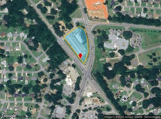
5680 Quintette Rd, Milton, FL 32571
Property Detail
5680 Quintette Rd
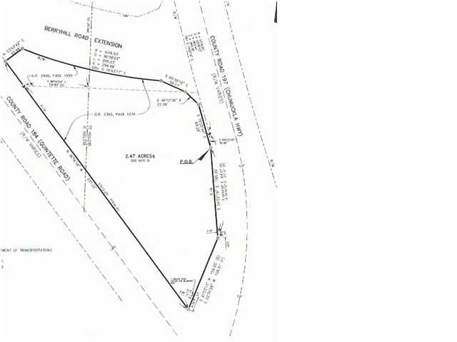
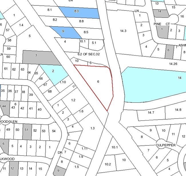
32-2N-29-0000-00600-0000
**NEW DESCRIPTION FOR 2021 PER SEP REQ SPLIT #1.12 SEC 32** COM AT NW CORNER OF SECTION 32 TOWNSHP 2 NORTH RANGE 29 WEST THN S1*0354W ALONG W SEC LN 840.00 FT THN S88*5606E 147. 83 FT TO W R/W OF CHUMUCKLA HWY (SR #197) THN SE ON CURVD R/W (R=5779.65
Storemultistory
SANTA ROSA
HCD
Florida
B and X Area of moderate flood hazard, usually the area between the limits of the 100-year and 500-year floods.
1.89 AC
2024
Avalon Beach/Milton
2025
Pensacola
010302
Pensacola-Ferry Pass-Brent, FL
15,943 SF
NEARBY LISTINGS FOR SALE OR LEASE
-
-
View all Milton listings for sale on LoopNet.com
DEMOGRAPHICS near 5680 Quintette Rd
1 mile
3 mile
5 mile
2025 Total Population
3,950
21,415
37,167
2030 Population
4,269
23,104
40,153
Pop Growth 2025-2030
+ 8.08%
+ 7.89%
+ 8.03%
Average Age
41
40
40
2025 Total Households
1,393
7,517
13,275
HH Growth 2025-2030
+ 7.82%
+ 7.68%
+ 7.81%
Median Household Inc
$108,965
$97,520
$91,432
Avg Household Size
2.80
2.80
2.80
2025 Avg HH Vehicles
2.00
2.00
2.00
Median Home Value
$390,352
$356,203
$334,213
Median Year Built
2003
2002
2000
Nearby Places
Map Layers
Map Styles
 Street
 Aerial
Layers
 Traffic
 Biking
Places
Listings with unknown addresses are not visible on the map
- Restaurants
- Banks
- Shops
- Fitness
- Groceries
PUBLIC TRANSPORTATION
AIRPORT
Pensacola International
Drive
Walk
Distance
Pensacola International
27 min
15.1 mi
Freight Ports
Port of Mobile
Drive
Walk
Distance
Port of Mobile
77 min
63.9 mi
Nearby Properties
Address
Land Use
TOTAL SIZE
Lot Size
Zoning
Address
Land Use
TOTAL SIZE
Lot Size
Zoning
164,185 SF
31.45 AC
AG-RR
Address
Land Use
TOTAL SIZE
Lot Size
Zoning
47.05 AC
AG-RR
Address
Land Use
TOTAL SIZE
Lot Size
Zoning
52,875 SF
5.24 AC
HCD
Address
Land Use
TOTAL SIZE
Lot Size
Zoning
51,329 SF
5.65 AC
HCD
Address
Land Use
TOTAL SIZE
Lot Size
Zoning
23.33 AC
AG-RR
Address
Land Use
TOTAL SIZE
Lot Size
Zoning
93,476 SF
7.43 AC
HCD
Address
Land Use
TOTAL SIZE
Lot Size
Zoning
94,231 SF
14.72 AC
HCD
Address
Land Use
TOTAL SIZE
Lot Size
Zoning
389.54 AC
AG-RR
Address
Land Use
TOTAL SIZE
Lot Size
Zoning
80,141 SF
11.33 AC
HCD
Address
Land Use
TOTAL SIZE
Lot Size
Zoning
602.07 AC
AG-RR
Address
Land Use
TOTAL SIZE
Lot Size
Zoning
25,700 SF
4.34 AC
HCD
Address
Land Use
TOTAL SIZE
Lot Size
Zoning
45,825 SF
3.26 AC
HCD
Address
Land Use
TOTAL SIZE
Lot Size
Zoning
35,878 SF
10 AC
HCD
Address
Land Use
TOTAL SIZE
Lot Size
Zoning
26,638 SF
3.08 AC
HCD
Address
Land Use
TOTAL SIZE
Lot Size
Zoning
27,839 SF
4 AC
AG-RR
Address
Land Use
TOTAL SIZE
Lot Size
Zoning
34,880 SF
2.42 AC
HCD
Address
Land Use
TOTAL SIZE
Lot Size
Zoning
14,765 SF
173.09 AC
R1
Address
Land Use
TOTAL SIZE
Lot Size
Zoning
71.77 AC
R2
Address
Land Use
TOTAL SIZE
Lot Size
Zoning
19,054 SF
25 AC
AG-RR
Address
Land Use
TOTAL SIZE
Lot Size
Zoning
2,324 SF
19.68 AC
HCD
Address
Land Use
TOTAL SIZE
Lot Size
Zoning
16,211 SF
2.05 AC
HCD
Address
Land Use
TOTAL SIZE
Lot Size
Zoning
8,574 SF
1.64 AC
HCD
Address
Land Use
TOTAL SIZE
Lot Size
Zoning
24,567 SF
2.82 AC
HCD
Address
Land Use
TOTAL SIZE
Lot Size
Zoning
11,713 SF
1.58 AC
HCD
Address
Land Use
TOTAL SIZE
Lot Size
Zoning
28,576 SF
3.49 AC
HCD
Address
Land Use
TOTAL SIZE
Lot Size
Zoning
8,703 SF
1.42 AC
HCD
Address
Land Use
TOTAL SIZE
Lot Size
Zoning
22,876 SF
4.05 AC
AG-RR
The World's #1 Commercial Real Estate Marketplace
Connect with us
© 2026 CoStar Group
The information above has been obtained from sources believed reliable. While we do not doubt its accuracy we have not verified it and make no guarantee, warranty or representation about it. It is your responsibility to independently confirm its accuracy and completeness. Any projections, opinions, assumptions, or estimates used are for example only and do not represent the current or future performance of the property. The value of this transaction to you depends on tax and other factors which should be evaluated by your tax, financial, and legal advisors. You and your advisors should conduct a careful, independent investigation of the property to determine to your satisfaction the suitability of the property for your needs.