Property Record
5682 Duncan Rd, Punta Gorda, FL 33982
This Property Is For Sale
Property Detail
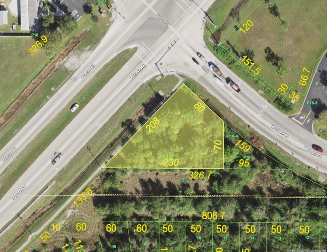
5682 Duncan Rd
402334380001
34 40 23 P-2-1-2 0.45A M/L A PORTION OF SE1/4 OF SW1/4 DESC AS COMM SE COR SW1/4 TH N 50FT FOR POB CONT N 70FT NW 80FT SW 208FT E 230FT 333/740 576/177 629/1737 1102/1797 2159/1344-59 2966/595
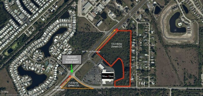
Commercialacreage
CHARLOTTE
CG
Florida
AE The base floodplain where base flood elevations are provided. AE Zones are now used on new format FIRMs instead of A1-A30 Zones.
0.45 AC
2025
Charlotte County
2025
Southwest Florida
010200
Punta Gorda, FL
NEARBY LISTINGS FOR SALE OR LEASE
DEMOGRAPHICS near 5682 Duncan Rd
1 mile
3 mile
5 mile
2025 Total Population
2,300
11,770
51,323
2030 Population
2,509
12,945
56,690
Pop Growth 2025-2030
+ 9.09%
+ 9.98%
+ 10.46%
Average Age
52
48
55
2025 Total Households
1,063
5,304
24,374
HH Growth 2025-2030
+ 8.94%
+ 9.86%
+ 10.38%
Median Household Inc
$56,562
$54,700
$68,904
Avg Household Size
2.10
2.10
2.00
2025 Avg HH Vehicles
2.00
2.00
2.00
Median Home Value
$239,759
$311,840
$352,047
Median Year Built
1992
1994
1995
Nearby Places
Map Layers
Map Styles
 Street
 Aerial
Layers
 Traffic
 Biking
Places
Listings with unknown addresses are not visible on the map
- Restaurants
- Banks
- Shops
- Fitness
- Groceries
PUBLIC TRANSPORTATION
AIRPORT
Punta Gorda
Drive
Walk
Distance
Punta Gorda
7 min
3.4 mi
Southwest Florida International
Drive
Walk
Distance
Southwest Florida International
46 min
37.8 mi
Nearby Properties
Address
Land Use
TOTAL SIZE
Lot Size
Zoning
Address
Land Use
TOTAL SIZE
Lot Size
Zoning
349,844 SF
78.47 AC
P
Address
Land Use
TOTAL SIZE
Lot Size
Zoning
164,121 SF
44.20 AC
ECAP
Address
Land Use
TOTAL SIZE
Lot Size
Zoning
77,154 SF
10.30 AC
CC
Address
Land Use
TOTAL SIZE
Lot Size
Zoning
161,439 SF
171 AC
RE1
Address
Land Use
TOTAL SIZE
Lot Size
Zoning
121,585 SF
696.03 AC
RE1
Address
Land Use
TOTAL SIZE
Lot Size
Zoning
345,043 SF
33.12 AC
ECAP
Address
Land Use
TOTAL SIZE
Lot Size
Zoning
254.31 AC
PD
Address
Land Use
TOTAL SIZE
Lot Size
Zoning
62,415 SF
281.65 AC
ECAP
Address
Land Use
TOTAL SIZE
Lot Size
Zoning
15,253 SF
13.27 AC
P
Address
Land Use
TOTAL SIZE
Lot Size
Zoning
208,560 SF
36.69 AC
PD-GM
Address
Land Use
TOTAL SIZE
Lot Size
Zoning
385,350 SF
374.81 AC
ECAP
Address
Land Use
TOTAL SIZE
Lot Size
Zoning
134,308 SF
16 AC
RSF3.5
Address
Land Use
TOTAL SIZE
Lot Size
Zoning
125.54 AC
PD
Address
Land Use
TOTAL SIZE
Lot Size
Zoning
24,880 SF
84.50 AC
PKR
Address
Land Use
TOTAL SIZE
Lot Size
Zoning
30,940 SF
0.42 AC
NC
Address
Land Use
TOTAL SIZE
Lot Size
Zoning
116,186 SF
20.02 AC
RMF10
Address
Land Use
TOTAL SIZE
Lot Size
Zoning
181,137 SF
12.34 AC
NR-15
Address
Land Use
TOTAL SIZE
Lot Size
Zoning
19,271 SF
3.51 AC
SP
Address
Land Use
TOTAL SIZE
Lot Size
Zoning
49,958 SF
6.81 AC
CC
Address
Land Use
TOTAL SIZE
Lot Size
Zoning
136.11 AC
ECAP
Address
Land Use
TOTAL SIZE
Lot Size
Zoning
60,000 SF
9.87 AC
ECAP
Address
Land Use
TOTAL SIZE
Lot Size
Zoning
66,461 SF
10.86 AC
CG
Address
Land Use
TOTAL SIZE
Lot Size
Zoning
54.25 AC
RMF10
Address
Land Use
TOTAL SIZE
Lot Size
Zoning
103,870 SF
17.06 AC
CG
Address
Land Use
TOTAL SIZE
Lot Size
Zoning
1,556 SF
23.08 AC
CG
Address
Land Use
TOTAL SIZE
Lot Size
Zoning
7,964 SF
7.86 AC
ECAP
Address
Land Use
TOTAL SIZE
Lot Size
Zoning
14,980 SF
2.57 AC
OMI
Address
Land Use
TOTAL SIZE
Lot Size
Zoning
60,000 SF
1.44 AC
ECAP
Address
Land Use
TOTAL SIZE
Lot Size
Zoning
60.56 AC
PD
Address
Land Use
TOTAL SIZE
Lot Size
Zoning
46,912 SF
3.41 AC
CG
The World's #1 Commercial Real Estate Marketplace
Connect with us
© 2026 CoStar Group
The information above has been obtained from sources believed reliable. While we do not doubt its accuracy we have not verified it and make no guarantee, warranty or representation about it. It is your responsibility to independently confirm its accuracy and completeness. Any projections, opinions, assumptions, or estimates used are for example only and do not represent the current or future performance of the property. The value of this transaction to you depends on tax and other factors which should be evaluated by your tax, financial, and legal advisors. You and your advisors should conduct a careful, independent investigation of the property to determine to your satisfaction the suitability of the property for your needs.